
-
 29428 Hits
-
 75.81% Score
-
 6 Votes
|
|
Route |
|---|---|
|
|
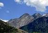
40.60900°N / 111.741°W |
|
|
Class 2-3 scramble |
|
|
Half a day |
|
|
Walk-up |
|
|
Approach
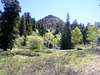
From Wasatch Boulevard, turn left at the 4-way intersection with Bengal Boulevard. Turn left on 3775 E (first left on the road), and then turn right on Timberline Circle. The trailhead begins at a dirt road. There are some signs for the trailhead that are easy to see. Park anywhere along the residential streets.Route Description
Elevation Gain: 4,324 ftDistance: 3.5 miles
Difficulty: Moderately Strenuous - Class2-3
Follow the dirt road as it enters the canyon. There are lots of popular climbing walls at the mouth of the canyon, and use-trails abound, so take care to stay on the MAIN trail that cuts through these areas. The trail is seldom used, so it is thickly covered in vegetation and at certain times of the year part of the river overflows into the trail.
As you pass flat ground in the climbing areas, there will be a quartzite wall that blocks progress up the canyon, dropping directly into the river. Cross the river to the north side here and continue up a STEEP hill. About 100 yards up the stream, just past this cliff, cross the stream back to the south side. The trail continues steeply up the canyon, crossing again to the north shortly before a few flat switchbacks begin. Continue straight at the final switchback to reach a viewpoint, or double back to your right to continue up the canyon.
The trail becomes much more rough and overgrown from this point. Eventually the trail crosses the stream once more, and follows along the northern edge of a steep meadow below some cliffs on the south side of the canyon. At the far side of the meadow (ca 7,800 ft) the trail drops into a dry stream bead, meandering in and slightly out of if as you pass cliffs on the southern side of the canyon. After a long, steep straightaway, the upper meadow is reached and the trail flattens again. From here the trail becomes practically nonexistant. Cut through the connected series of meadows on the north side of the canyon until you reach the start of either route variation:
West Ridge: Class 3
This route has minimal vegetation and some nice class 3 walls that interrupt a class 2 ridge as one climbs the final few hundred feet to the summit. To access this route, aim toward the lower left side of the summit that looms above as you travel through the meadow. Eventually a large chute can be seen cutting through the cliffs - it has a pine tree growing in it. Climb up this chute and midway up follow a prominent ledge system that cuts back to the west. These ledges drop you off on the ridge. From here, just scramble to the summit.
East Ridge: Class 2-3
Although this route is the standard way to access the summit, it sucks. It requires more crosscountry travel across the upper meadow before scrambling begins, and there is much brush to navigate while scrambling. To take this route, continue up the north side of the upper meadow until a low point beyond the Storm Mountain summit is reached in the headwall. Scramble up to this, and then follow the ridge to the left until the summit is gained.
 |  |  |
Essential Gear
10 EssentialsHelmet if traveling in a group
Ice axe, crampons, snow shoes might be useful between November and June
Moogie737 - Sep 1, 2009 4:58 pm - Voted 10/10
Trailhead improvementsAs of August 2009 one can find paved parking spaces, a drinking fountain (two spigots for people, one for dogs!) and a small improved trail leading up through a mini-amphitheater. I think there were about 15 parking spaces. This is a great improvement and I am sure the neighbors appreciate the cars being off of the street. :)