
|
|
Route |
|---|---|
|
|
38.75400°N / 104.948°W |
|
|
Hike |
|
|
Half a day |
|
|
Walk-up |
|
|
Approach
Take Gold Camp Road to 379. At 379 turn north, but you will need a high-clearance vehicle as there will be a stream-crossing or two and several rough spots with large rocks in the road. People without SUVs can park just after the turnoff onto 379 and hike an additional mile to Frosty Park and the Nelsons Trail.
 |  |
Facts
From Frosty Park (folks with SUVs):
Elevation Gain - 1200'
Starting Elevation - 10255'
Length - 3.5 miles out and back
From Gold Camp Road (can't quite clear those rocks):
Elevation Gain - 1700'
Starting Elevation - 9800'
Length - 6.5 miles out and back
Route Description
From Nelsons trailhead, head north through a wide section of trail. As you come into the forested area, you will see a few cairns on the right leading into deeper woods. Turn at a new trail marker for Trail 672 that will start you going up the mountain. (Thanks to mmoerk for that correction)
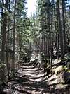
The trails are not heavily used, but lower portions have experienced some damage from motor vehicles (now illegal on the trail). Continue up through the steepest part of the climb which winds around the north side of the mountain. Make sure to turn around and look behind you for some great views of Pikes Peak as you climb.
At the top of this climb where the trail levels off a bit is a large clearing. As you enter this clearing, keep a look out on the right for a few cairns and a trail leading up the ridge to Rosa's summit.
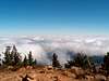
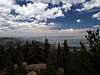
From here on, the trail is fantastic. It's easy to see and yet it is not as gnarly as some earlier parts of the trail. You'll soon come across a fantastic ridge where there are few trees and you can start to see Colorado Springs on the left and a beautiful overlook of mountains (including Pikes Peak) on the right.
Also on this ridge, you should notice that the summit of Rosa is directly in front of you beckoning you on.
Now you climb back into the trees, and after a little more hoofing you'll reach the false summit. But just keep on, because it's not much further now.
Back into the trees again for one last time, and you climb around some pretty old evergreens in a nice quiet climb the rest of the way. In fact, many of these ponderosa pines are between 300 and 500 years old with the oldest ponderosa pine in Colorado on this mountain at 780 years old. Pretty soon, you come out of the trees and come around the bend to the cluster of rocks that make up the summit of Mount Rosa.
Standing on the top of Rosa is an awesome experience, because you can literally turn around in one spot and see 360 degrees of beautiful Front Range mountain and city views.
 |  |  |
Essential Gear
Nothing special, just hiking boots and water. You might want to bring a light windbreaker as the winds can be quite strong on the ridges and summit. It's also a good idea to come prepared for rapidly-changing weather as is necessary for any hike in Colorado.
You definitely shouldn't forget that camera on this hike. If you do, you'll be kicking yourself all the way down.
tojensen - Sep 4, 2011 11:28 am - Hasn't voted
trail correctionAbout a quarter mile from the trailhead, you come to a T intersection. Current route description says to go left at route 672 marker. In fact, you must turn right. Also, about 2/3 the way up there is another intersection where 672 goes straight, but you mst turn right to follow the ridge to the summit. The intersection is marked by roks and cairns