Introduction
May was an incredible month in Washington State. The sun seemed to shine every weekend and the mountains just seemed to be coming out at a rapid rate. It seemed like every three days I was able to knock off an excellent mountain and have a great trip. Unfortunately June has been the very opposite of May. The weather in the mountains has been cold, snowy and many times not safe for climbing. It has gotten to the point that the news is now reporting on a daily bases another death or another set of lost climbers in the mountain. There have also been a number of avalanche warnings produced this year. For the climber, who thrives on the snow-climbs and the warm temperatures that June usually produces this has been disappointing.
![Map of my route]() Map of our route
Map of our route
For the third week in a row my plans to do a trip to Dragontail, the highest peak in the Enchantments area fell through. This reason was because weather, gas and money. When plans fell through for a trip to Dragontail, Zephyr and I decided to head to the Teanaway and go for Deroux Peak. Typical this area is a warmer drier area in the Cascades. We knew there might be some snow from our trip to Jester the week before but we did not expect snow to be in patches all the way to the valley floor. Thankfully we brought our ice axes and microspikes. At one point we questioned if we needed crampons due to the fact that the snow at times was incredibly hard.
Heading up in the surprising snow
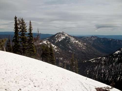
The patchy snow started right from the start of the trip. The first part of this trip the snow made little or no impact. But as we went up the snow picked up substantially. On the way up we went up the Gallagher Lake Trail all the way up to the largest and last waterfall where the snow was now pretty much covering the entire trail. This snow will probably not melt out until early to mid-July.
![Zephyr climbing up the gully]() Heading up the steep gully
Heading up the steep gully
Once at the consistent we left the trail area and headed up to what on the map looked like a good gully to the ridge. We found the gully and although it was steep (40-50 degrees) it was probably the best way up the mountain. I lead this up this solid section of snow. At first though the snow was solid I was able to kick really good steps in the snow with micro-spikes. But this changed slowly but surely the higher up we went. Once above 6000 feet the snow was very hard to kick into and we had a hard time getting traction here. At one point both Zephyr and I slipped and he had to self-arrest.
The Summit Ridge
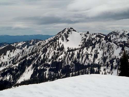
![Koppen from Deroux Peak]() On the ridge to Deroux looking at Koppen
On the ridge to Deroux looking at Koppen
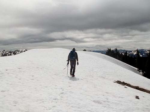
After a struggle up the ridge we hit the ridgeline where great views opened up. We could see both Koppen in the southern part of the ridge and the Stuart Range to the north. From there we followed the ridge all the way to the summit of Deroux Peak. The ridge itself was narrow and did have dropoffs to the north and the south but it was easy enough to travel on and no where near a knife-edge quality. You could see where many of the cornices had developed on the ridge. We traveled over them staying away from the ridges of these cornices. Soon we at the finally ridge.
![Heading up to the summit of Deroux]() Nearing the summit of Deroux
Nearing the summit of Deroux![Summit cornice]() The summit cornice
The summit cornice
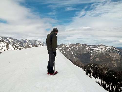
We were greeted by an awesome south facing cornice on the side of Deroux Peak. This was an awesome site to see such a large cornice. Though we took some good pictures of it we stayed away from the edge and the fracture marks the cornice was making in the snow. Wew got to the other side of the cornice and enjoyed lunch in a flat field 100 feet below the summit. From the top of Deroux there are good views of Stuart, the Enchantments and most of the summit of the Teanaway Region. Even though it was cloudy and cold this summit was excellent.
![Skookum from Deroux]() Skookum and Jolly from Deroux.
Skookum and Jolly from Deroux.![Closeup of Stuart from Deroux]() A closeup of Mount Stuart from Deroux
A closeup of Mount Stuart from Deroux![Koppen from Deroux]() Koppen from the summit of Deroux
Koppen from the summit of Deroux![On the summit]() On the summit
On the summitGlissades, Avalanche Debris and Iffy Conditions
![Dude we are going to glissade that!!!]() Dude, we are glissading that!!!!
Dude, we are glissading that!!!!
On our way back we wanted to avoid the tricky icy section. The snow on the south facing snow was looking good and though it was somewhat firm it looked good for a slow controlled glissaded. Not ideal for a speedy glissade though because there were trees below and it would be quite easy to gather speed here. We knew if we could make it down this slope the rest of the trip would be much easier than heading up. So after a number of controlled glissades down nearly 1000 feet of elevation we reached an area that was a debris field from an earlier avalanche field. The avalanche from this mountain must have been recent based on all of the fresh debris that was picked up. There were a number of large branches we ran into on the way down the mountain.
![Deroux Peak from Deroux Spur]() Last view of Deroux Peak
Last view of Deroux Peak
We walk the rest of the way down to the valley where we cut left (the trail was completely snow-covered) and headed on through until we reached the first open area which was the Deroux Spur Trail. We took the mostly snow free (in the open area) Deroux Spur Trail over the pass where we again hit some iffy conditions on the way down. Oh great here we go again. A steep slope that was covered with snow and also half covered with bushes and slide alder. It was very hard to get any sort of traction in this stuff. For 300 feet Zephyr and I really had to take our time on this tough stuff.
Luckily these iffy conditions were brief but the trail itself will not be good for regular hiking for at least two weeks. About 400 feet below we finally got a better sense of the trail. From that point on the snow became patchy in nature back to the car. We still needed our axes to help us balance ourselves on some of the snowier patches on the trail. The lower though we went the clearer the trail became. Finally word the bottom of the trail it became much easier for us to travel and we packed away our ice axes for good. The rest of our trip back to the car was uneventful. After 8 hours of hiking, scrambling, glissading, and snow climbing, we were back at the car and ready to head back.
Conclusion
I want to thank Zephyr for coming out and doing this mountain with me. Once again we were a very successful team. We both fed off of each others strengths and ended up with another great summit despite questionable and iffy conditions. The glissade rank aamongst this year's best.
Typically many of these mountains are clear of snow by early and mid-June. Due to the cool June this is not the case even here in the Teanaway Region of the Cascades. For those looking for snow free hiking hold off hiking this section of the Teanaway for a couple weeks and instead head over to Jester, and Roughhouse. The snow here will be around until at least early July. Hopefully the weather will break soon so that my plans for Dragontail and Little Tahoma can actually happen.


Comments
Post a Comment