
-
 5336 Hits
-
 0% Score
-
 0 Votes
|
|
Route |
|---|---|
|
|
33.95530°N / 109.1242°W |
|
|
Hike |
|
|
Most of a day |
|
|
Walk-up |
|
|
Approach
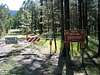
FR 56 is 20.5 miles south of Springerville and 5.5 miles north of Alpine on US 180/191. Head east and follow the well signed road past the left turn for Hulsey Lake (1.6 miles from US 180/191) and the closed left turn for Watts Creek FR 56A (1.9 miles in). The following left turn (2.6 miles) is also closed and bears a sign for the Wildlife Habitat Area as well as a plastic blue diamond on a pine tree. This is where you park for the Government Trail #119.
 |
Route Description
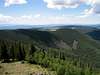
This trail is less scenic than the Escudilla National Recreation Trail #308 but is also less traveled. It begins at roughly 9,100 feet and climbs approximately 1800 feet in elevation over 4.2 miles. It starts at a closed forest road gate and follows the forest road through a mixed conifer and aspen forest towards the Escudilla Wilderness boundary. Blue diamond tags are on trees to lead you through the backcountry roads to the trail. In the absence of a blue diamond, follow the primary road and you will do fine. Approximately one mile in you will reach a gate, pass through it and close it behind you. Continue your slow ascent as Hulsey creek approaches on the right, and Milk creek off to your left. At 1.46 miles you will reach a fork with a blue diamond in the center, although it may be difficult to see. Go right. Ponderosa pines decrease in number while aspen and other conifers begin to dominate. At 1.64 miles the road takes a 90 degree turn to the left and just after the turn look to your right for the last blue diamond marking the Wilderness boundary and the beginning of the foot trail. The wooden trail sign is currently on a fallen pine tree so it may not be visible. To assist in finding this junction it is located at 33.93671 deg. N, 109.12217 deg. W (NAD27) at an elevation of 9716 feet. The foot trail is steeper and becomes rockier as it switchbacks through the wooded talus slopes above. You will emerge into a meadow 2.34 miles from your car. Continue through the meadow on a faint to non-existent track to the signed junction with Escudilla National Recreation Trail #308. This point is approximately 2.47 miles from your starting point. Turn left at the signed junction and follow trail #308 as it climbs north through the meadow re-entering the conifer forest at around 10,600 feet. It then turns to the northwest before terminating at the fire lookout tower (~3.6 miles from your car). The lookout tower is actually at an elevation of 10,877 feet. The true high point of Escudilla Mountain is 0.6 miles to the north at an elevation of 10,912. Cross-country travel is necessary to reach the 3-4 foot high rock cairn at the true summit of Escudilla Mountain. The conifers at the summit block the beautiful vistas that are available from the lookout tower.
 |
Essential Gear
Typical hiking equipment. Be prepared for inclement weather any time of year. A GPS, map, & compass will be useful in finding the true summit from the lookout tower.
Miscellaneous Info
If you have information about this route that doesn't pertain to any of the other sections, please add it here.