
-
 15141 Hits
-
 78.1% Score
-
 9 Votes
|
|
Route |
|---|---|
|
|
45.95000°N / 7.30000°E |
|
|
Mountaineering |
|
|
Summer |
|
|
Most of a day |
|
|
AD 45°/II° |
|
|
Approach
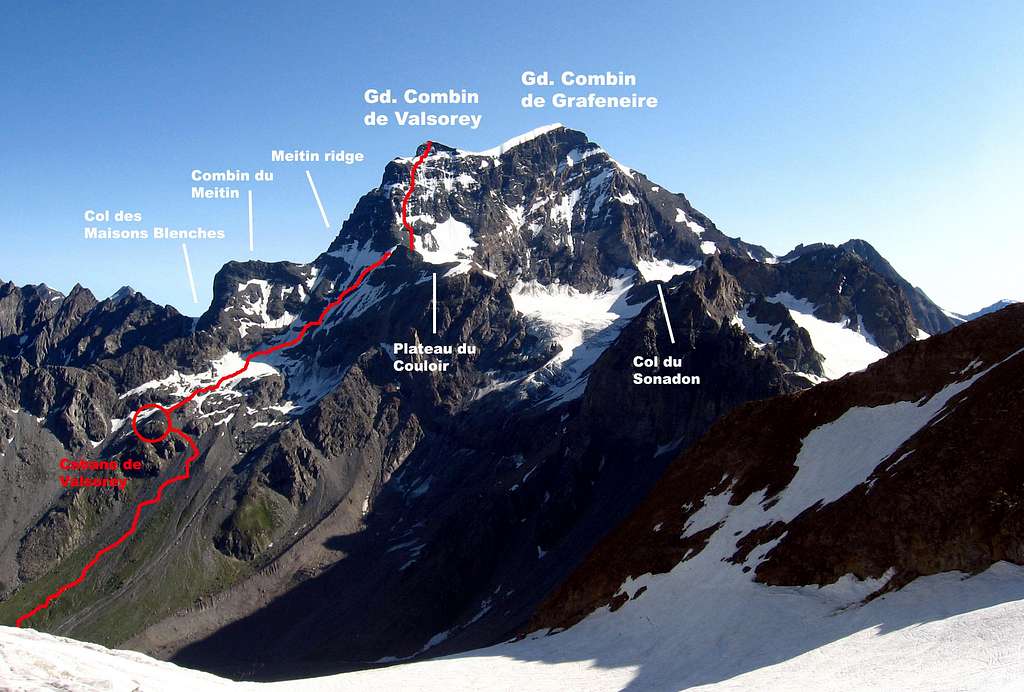
"Spalla Isler" (shoulder Isler) is the name of the entire southwest flank of the Grand Combin. It's not a real rocky ridge, and the route doesn't follow a precise direction. The rock quality is quite bad, so would be advisable to choose the route in relation of the snow condition. The route follow a series of couloirs without passages obliged. The route starts from the Plateau du Couloir (3.645m), near to the bivouac "Musso".
This place can be reached usually from the Cabane de Valsorey (3.037m) (Schweiz) or also from the refuge Francesco Chiarella all'Amiante (2.979m) (Italy).
From Refuge Amiante:
From the hamlet of Glacier in Valpelline (Aosta Valley), follow the track for By that part just before the bridge that goes back a series of bends and the wooded shoreline. When you reach a small church on the edge of the large grassy hollow of By, turn right past the house from Farinet (2.009m).
At a junction, leave on the right, this itinerary for Fenetre Durand and, continuing on the left along the road, to reach Alpe di By (2.048m). At the first huts, take the path on the right that goes up through the pastures crosses the valley that descends from the Col de Bonamort, to the pasture of Tsa de la Commune (2.302m).
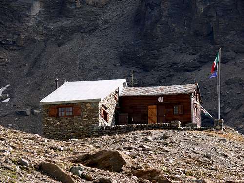
From here, continue going up diagonally to the left, pass under the lower rocks of Punta Rats and come into a valley, then we move on his left coast (going up). Climb the steep grassy rib, which is more up debris along along the trail up to take you under in the rocky plates that are overcome with the help of a chain, paying attention to the debris until the present. Reached a rocky shoulder, climb still a stretch right through rocky debris, until you reach the refuge all'Amiante Francesco Chiarella (2.979m) (time required is 3.30/4.30 hours).
From the refuge turn to the left toward the Great Tete de By scree and snow traits. Without climbing to the left of the saddle, you earn the right for easy snowfields till the col d'Amiante (3.308m).
From the pass you go down lightly on the glacier du Mont Durand, it must be cut along a kind of wide ledge between big crevasses to move near the base of the south-east ridge of Grand Combin de Grafeneire. Hence, for a large, easy slope (crevasse), climb to the Col du Sonadon (3.504m).
Go down on the other side taking care to some treacherous crevasse just below the hill and through the top of the glacier du Sonadon which leads you to the foot of a rather steep snowy slope (bergschrund, danger of falling rocks from the wall of the Grand Combin), which earns the wide saddle below the south face (3.645m), called Plateau du Couloir.
From Cabane de Valsorey:
Just after exiting the tunnel the Grand St. Bernardo turn right on a narrow paved road (sign Valsorey - Velan). It goes in the direction Cordonna, until you come to a dirt road that bends to the right (clear arrow Valsorey - Velan). Here begins the beautiful path (starting altitude 1.800m approximately) leading to the Cabane du Velan and the Cabane de Valsorey. After about 40 minutes of hike you reach the junction (good signs), take to the left towards Valsorey hut.
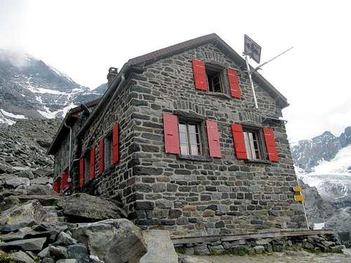
The refuge is placed on a rocky pulpit at (3.037m). The time required is 3/4 hours. The hut is cozy, with a very quiet and extremely helpful manager (it is also a mountain guide).
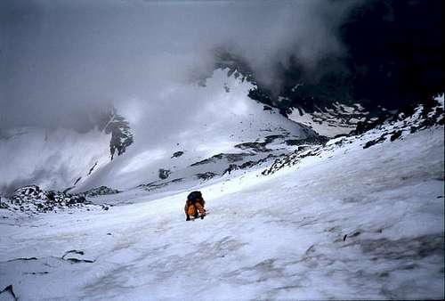
From the hut, go back along the trail to the small glacier above. Cross the glacier keeping rather upstream until you reach a slope of ruins.
If there is no snow you can find traces of the passage (the slope, in the dark, it may be some pitfall). To reach the Plateau du Couloir you should do a traverse to the right (normally on snow-ice) that can be more or less accentuated, depending on the line of ascent of the previous slope (choose to make the traverse higher or lower depending on the condition of the wall and the great couloir that descends from the Combin de Valsorey.
Route Description
The difficulty of the route can vary greatly depending on the conditions of the mountain. The guides and the books of the refuge Valsorey rate it AD. It is technically easy, but probably more dangerous then the Aréte du Meitin. The traverse of the face in the afternoon can be very dangerous, just below the big couloir that descends from the Combin de Valsorey, falling stones are quite frequent.
Route description:
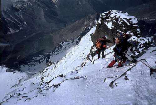
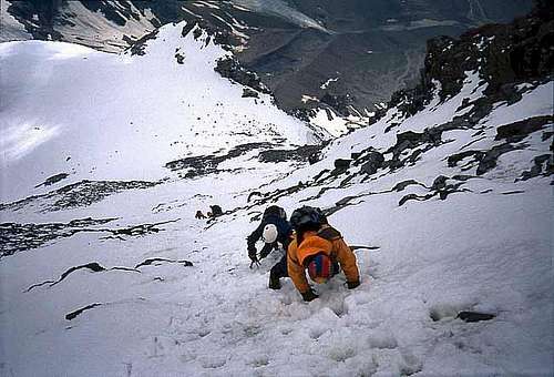
Once the Plateau du Couloir is reached (3.650m 2h'00/2h'30), the bivouac Musso is visible on the saddle (real eagle's nest!). At this point you begin to climb the proper south face (so called shoulder Isler). It is a very wide wall that should be preferably climbed on the left, the path is never required but often it is not entirely clear, for which the only indication is to remain on the edge of the rib rocky (slopes of debris until 45° and a few steps II in the final stretch).
From the Plateau du Couloir, climb initially for easy snowy slope that late in the season may be debris, you move to the right of an obvious groove that separates two rocky towers, climbing through rocky terrain is not difficult. Continuing snowy slopes (at the top some stretch to 45°) and sometimes long rocks and grooves (steps of II) you will come to a snowy shoulder (4.095m) near the Meitin ridge.
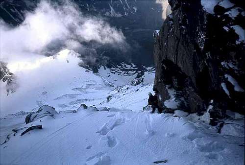
The face, depending of the time can be covered of snow or complitely dry. In case of snow, is better to keep the center of the face finding the safest passages. In case of dry rocks, better to stay on left (your) almost on the SW edge of the mountain. In any cases, the south face still very dangerous, and an error could cause to fall for hundreds of meters! The south face finish at the foot of the Combin the Valsorey.
Turn right on snow and debris to avoid the steep rocky ledges, then climb vertically to rocks rather difficult but not broken (II) that require a lot of attention (especially if snow), until you get to the top of the Combin de Valsorey (4.184m).
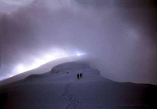
From the summit of the Grand Combin de Valsorey (4.184m) the environment changes dramatically, and in about 1 hour you reach the highest peak of the Combin de Grafeneire (4.314m) following the easy snow slope down for 50m and up for 200m untill the snow dome.
The descent is along the same way. If the climb was demanding and tiring, the descent will be even more demanding for the continuing care to plant the axe and crampons in the right points, and for the continuous dizzying exposure.
During the day the temperature on the south side rise up very quicly, and the snow melts also very quicly. No possibility of rappeling.