Onwards to Montaña Blanca
![summit cone]() The actual summit cone of Teide
The actual summit cone of TeideTeide is actually a secondary volcanic cone that over the previous few thousand years has sprung up on the northwestern edge of a massive caldera that either quite literally blew itself apart or collapsed in upon itself some 150,000 years ago. The original explosion is thought to have been a 7 on the VEI
(Volcanic Explosivity Index). The original caldera measures 48km (~30 miles) in circumference or 15km by 10 km. Teide, though not the primary reason why I ventured to the Canary Islands did retain enough fortitude to keep it within my ponderings. So, after spending a week on the island of Tenerife becoming acquaited and situated with life on the island, I simply couldn’t resist Teide any longer and set out on a cold Wednesday morning to climb this bugger.
I set out from my timeshare at Amarilla Golf (at sea level) at around 7:00am (very early for Canarian standards). After spending roughly 30 minutes imbibing myself with some wonderful black necter at La Paz cafe in Vilaflor, I drove up into the National Park (Parque Nacional de las Cañadas Del Teide) which encompasses most of the center of the island. Since I had been up into the park the previous two days summiting other minor highpoints along the caldera wall, I pretty much knew exactly where to go. After 40 minutes and 7,450 vertical feet of sinuous driving, I arrived at the small parking area for Moñtana Blanca/Teide, which was basically nothing more than a cove scooped out of an old lava flow to keep parked vehicles off the road. I say that because tourists and local alike have a very strange idea of what constitutes reasonable parking.
As I said, the morning was actually rather cold and very windy (but nice down along the coast!). However, at least the day would be graced with endless blue skies and abundant sunshine. As a side thought before I left the States, I threw my Arc’teryx Delta jersey into my pack just in case ‘things’ were cooler than expected. It turned out to be the single best thing I could have brought. However, on this particular morning, it wasn’t enough.
![Teide from near Samana]() From near sandero #13 (Semana)
From near sandero #13 (Semana)But, fortunately, just the previous afternoon as I was wondering the chaotic streets of Los Christianos, I wandered into a shop that specialized in clothes and jewelry from Bolivia, Peru and Ecuador. I decided to treat myself and bought a pullover from Peru. I had no idea I’d be wearing it the very next morning.
![Looking down at Mña. Blanca]() Moñtana Blanca from a few meters up the lava fall.
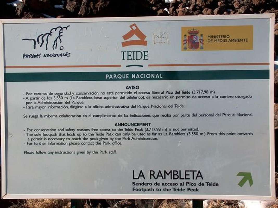
Moñtana Blanca from a few meters up the lava fall.Before I continue, I should probably state that the Canary Islands require would-be climbers to obtain a permit to access the remaining 511ft. (164m) to the summit cone. If one does not have a permit, the highest one can hike is to a point called “La Rambleta”. The altitude here is roughly 11,646ft (3,551m) and is also the same rough altitude where the cable-car stops running and lets passengers out. While in Santa Cruz (the capitol) a couple days previous to obtain this permit, I found out that permits were not being issued due to ‘meteorological conditions’. In other words, the summit cone was off-access due to snow and ice. So without a permit, and an operational cable-car, it looked like La Rambleta would be the highest I could go. After receiving a parking ticket at the airport (€90 or roughly $120.00) I really did not want to chance running into a park official or ranger and incurring another fine. So La Rambleta would be my final destination.
![Inside the caldera]() Looking down inside the caldera of Teide.
Looking down inside the caldera of Teide. The actual hike in started down a dusty service road. Which, taking in consideration the very soft terra and Martian-like landscape, was rather boring. About two kilometers up this road of white rock and pumice, a split occurs leading away to the right to what I believed was a weather station. Continuing to the left, the road switchbacks a good amount as it stays in line with the topography of Moñtana Blanca, 9,022ft (2,550m) a lower vent of Teide. A ranger was parked on the road in his jeep about 1/4 from Mña. Blanca's summit, so any off-piste treking probably would not have been a good idea. I stopped at the summit for the first time and took some pictures. Granted, the views from here of the old lava flows and the caldera are quite good and I am still enthralled with the softness of the ground but I am still pretty disappointed. So far, this is nothing to write home about.
The previous Monday, while I was sitting on the summit of
Guajara, 8,907ft (2,715m), I was looking out across the caldera over at Teide, closely studying it. It looked like or I had reasoned that the trail would simply follow the entire eastern slope up to La Rambleta/summit cone. At this point, I figured the most exciting thing about this mountain would be the Tetley’s and Strongbow afterwards at the pub. It had actually gotten windier and if my watch was correct, the temperature was somewhere in the neighborhood of 50°F. After 10 minutes or so, it was time to move on.
The trek up towards Teide
I followed a climber’s trail that left Moñtana Blanca and coursed straight up a lava flow. It switch-backed relentlessly between the coarse black lava and the weirdly brown-white soft terra. Hmmm…things were now starting to get interesting. Snow and patches of ice were now making their introduction on the trail. The climber’s trail turned out to be a steep little bugger! As it turned out, this trail never ventured anywhere near the eastern slope let alone flirted with it. I was actually thankful for that. The thing slithered back and forth straight up the old lava flow. The skies were still blue and sunny, the clouds, as usual, were abutting up against the coast and the wind was still blowing. Patches of the trail were entirely covered in snow and ice, more ice than snow. About ¾ the way up this trail, there is a hut or a refuge called the Rufugio de Altavista. I resolved myself to make this destination my extended lunch break. The views from here were nothing short of extraordinary. I could see the entire southern caldera wall as well as down to the ocean. Looking to the southeast, I was watching the clouds build up and abut against the steep barrancos (ravines) of the eastern coast. This was pretty cool. The clouds would swirl about and slowly move down the coastline. It reminded me of watching soap bubbles on the waters' surface when taking a bath as a kid! Well, after 15 minutes, it was time to move on. The trail was all ice and snow now. Smiling, I thought crampons would be SO nice to have right now. I’m surprised I didn’t snap my trekking poles. It would have been a slow nightmare without them. If the remaining 511ft. to the top was going to be like this, I could kind of see why Park Administration would close off the summit cone. But being from Colorado, this still made little sense to me. I had to smile at that thought.
![Rufugio de Altavista]() The Refugio de Altavista
The Refugio de Altavista
From the rufugio to
La Rambleta, it couldn’t have been anymore than two icy kilometers. I took some more pictures and sat down next to the sign. It then just occurred to me that I hadn’t seen any cable-cars running all morning. I traversed over to the main housing where the cable-cars load and un-load and it was indeed closed. There were what sounded like 2-3 people inside doing maintenance work. Plus, the summit cone was entirely free of all snow and ice; huh, meteorological conditions my ass. If the cable-car wasn’t running then there would be no park rangers up here or park staff. Screw it, I’m going up.
![Enjoying the view]() Taking in the whole vista!
Taking in the whole vista!
From La Rambleta to the summit cone, it took me dam near 45 minutes. The earth was so exceedingly soft. For every 2-3 paces I took, I would slide back one pace. It was like walking on hardened ash and super-soft pumice. Everything was white with occasional splotches of red and off-brown. Closer to the summit, I ventured to the solid rock. At least the going would be more secure. But this was actually freaking me out a little because in some of the recesses of the rock, once in a while, a whisp of sulphur would exit next to me.
The
views from the top were absolutely incredible! Looking straight west, I could see the island of La Gomera. Looking southeast, I could see the island of Gran Canaria and just peeking in the distance to the northwest was the island of La Palma. The actual caldera of Teide was filled in with quite a bit of rubble. I could see huge patches of green (sulphur crystals) and decently-sized releases of sulphur gas from these patches inside the caldera. There were two other people up there also and two others making their way up.
I have to say, the morning turned out to become a wonderful day. I stayed maybe 10 minutes up at the top. The sulphur was intolerable and it was giving me a headache. Even a lactose-intolerant person binge drinking milk all night couldn’t compete with that smell. I descended slowly with great trepidation. I don’t know, I think that if I landed too hard of a footfall, I would plunge through a hidden vent or something.
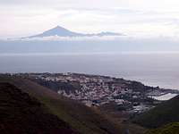
![From La Gomera]() Teide when viewed from La Gomera
Teide when viewed from La Gomera So it took me almost as long getting back to La Rambleta as it did ascending. Back at La Rambleta, I ran into a small group of four Germans. In broken German, English and Spanish, I somehow managed to convey to them that I had indeed just come back down from the summit and that they should go for the summit since the cable-car was not running today. And that one fellow should probably take off his red jacket. Just in case a park official down at the El Portillo visitor's center deceided to turn his binoculars towards the summit, especially against a back-drop of white; and that lowering their hats a little over their sunglasses would also be a good idea to cut down on the shine/glare from the sun reflecting off them, for the same reasons. Continuing down the trail, I ran into an older couple again that I had passed on the way up. I and the man, who was from Austria, had a great little conversation about skiing. He hadn’t heard of Vail but knew where Aspen was. We parted ways and I made it back down to my Citroën. I had stripped down to a T-shirt and shorts by this time and wondered how on earth everybody else I ran into could keep their jackets, pants and in a few instances, fleece hats on without becoming too warm. But I have a habit of putting it into full-throttle on the way down from (any) mountain I ascend. So this is probably why I was so warm later on during the descent. I drove back to my timeshare and unwound and relaxed at the pool with some wine.
![Coronal Forest overlook]() Teide and the eastern coast at dusk.
Teide and the eastern coast at dusk.


Comments
Post a Comment