
|
|
Route |
|---|---|
|
|
46.53182°N / 8.07778°E |
|
|
Mountaineering |
|
|
Spring, Summer, Fall, Winter |
|
|
Most of a day |
|
|
5.3 (YDS) |
|
|
PD+ |
|
|
II |
|
|
Overview
The Gross Grünhorn is one of the beautiful 4000er peaks in the Berner Oberland in Switserland. The view from the 4044 meter high top is nice as it is centrally located in the Berner Oberland mountain range. In the summer the mountain is often climbed and in winter ski ascents of the mountain are possible.The most climbed route is the normal route from the Konkordiahütte over the Grünegghorn. The route goes over beautiful glaciers, firn, snow and rock up to the final summit ridge of the Gross Grünhorn. The route is graded II or PD+. However depending on the circumstances the route difficulty and climbing time may vary. If the circumstance don't permit fast climbing there is always the possibility to limit the climb to the Grünegghorn which is a nice goal in itself. The ideal circumstances for the normal route are in the summer as too much snow can make the route a very tiring snow plod. To get an idea of the circumstances check the weather report and phone the Hütte (see External links section). After heavy new snowfall care should be taken below and in the couloir because of possible avalanche danger.
The normal route starts at the Konkordiahütte and the descent is back along the same route. There is the possibility of a traverse to the Finsteraarhornhütte on the descent. Either from the Grüneggfirn over the Grünhornlücke (3286 meter)(advised) or from the Lücke (approx. 3800 meter) between Grünegghorn and Gross Grünhorn (not advised). The later route requires multiple rappels down to the Fiescher glacier. There are bolted rappel anchors, however they are of no use if they are invisible due to the snow cover(which tends to happen relatively often).
The normal route is a nice route high up in the alps with nice views and nice climbing on the summit ridge. However, given the length it is not to be underestimated. Furthermore given the routes conditions the rock ridges may call for rock climbing with crampons.
All in all this is a nice and long route for experienced alpine climbers.
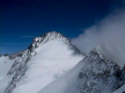 Gross Grünhorn and Grünegghorn
Getting There
The normal route onto the Gross Grünhorn can be climbed most easily from the Konkordiahütte which is run by the Swiss Alpine Club (SAC). When the weather is nice it can be filled with groups descending from the Jungfraujoch so it is good to reserve.The Hütte can be reached from Grindelwald (Kanton Bern) in this way by taking the railway up the Jungfraujoch (very expensive!) and hiking down the Jungfraufirn to the Konkordiaplatz. The Konkordiaplatz is usually crossed on the east side towards the rocks on which the Hütte is built. The Hütte is reached by climbing the stairs fixed to the rock face.
Alternatively the Hütte can be reached from Fiesch (Kanton Wallis) by hiking up to the Märjelensee. The Märjelensee can also be reached by taking the Luftseilbahn from Fiesch to Fiescheralp and walking through the tunnel to the See.
From the Märjelensee descend onto the Grossen Aletschgletscher. Head north on the Glacier at first close to the middle moraine (the eastern one). As you come close to the Hütte the route comes closer to the side moraine. The route finding through the crevasses to the rocks below the Hütte might take some time. Over the boulders and rocks the Hütte is reached with the help of some ladders, ropes and stairs.
Please be aware (as to my latest knowledge) that there is no stream to provide the Konkordiahütte with water and all water is collected from snowmelt by the Hüttenwart. Therefore there is not much water to go around and the only drinkable water available at the Hütte, collected with much effort, is sold per liter as cold or hot boiled water.
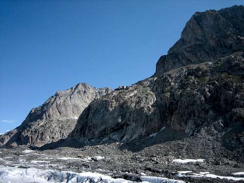 Konkordiahütte from glacier
Route Description
 Map: from Konkordiahütte over Grünegghorn to Gross Grünhorn (1: Konkordiahütte, 2: Konkordiaplatz, 3: Grüneggfirn, 4:Grünegghorn, 5: Gross Grünhorn, 6: Ewigschneefeld, 7: Grünhornlücke, 8: Klein Grünhorn)
From the Konkordiahütte (1) descend the stairs onto the glacier (Konkordiaplatz (2)) and head into an east northeasterly direction over the Grüneggfirn (3) towards the Grünhornlücke (7) (see map).
The route to the Grünhornlücke (7) is usually easy to find in summer as many people go over the lücke to the Finsteraarhornhütte.
From approximately 3000 meter height head north on the firn towards the ridge. There can be some small crevasses; generally it is best to stick to the west part of the firn close to the rocks in the lower part. The first lower part is pretty steep but after a while the route levels out somewhat. In the higher part, closer to the rocky SW ridge, the route continuous at a more respectable distance to the rocks. Now you should be able to see a steep couloir onto the SW ridge which is usually filled with snow or firn. Climb up steep snow or firn to the couloir and through the couloir onto the SW ridge.
Follow the broad, gentle sloped and firn covered SW ridge onto the west summit of the Grünegghorn. The Grünegghorn summit (4) at 3860 meter is reached easily over the rocky W ridge.
From the Grünegghorn descend onto the Lücke between Grünegghorn and Gross Grünhorn (5).(For faster climbing it is also possible to circumvent the rocky top of the Grünegghorn (and the rocky descent to the Lücke) by going through the firny northface of the Grünegghorn)
From the Lücke (approx. 3800 meter) head towards the summit SW ridge but watch out for crevasses in the Gross Grünhorn SW face. (Sometimes tracks head out somewhat into the snowy west face before reaching the summit SW ridge at a slight higher point.) Climb on the SW ridge, now and then staying on the western side of the ridge, towards the Gross Grünhorn Summit (4044 meter). The climbing difficulties are approximately II and take approximately an hour. The ridge offers plenty of opportunities for placement of slings or friends/cams if necessary.
The descent is normally along the same route as the ascent. Often the top of the Grünegghorn is circumvented through the north face on the descent.
After the descent and a short ascent on the stairs to Hütte you are back in the nice Konkordiahütte.
 Grüneggfirn to the Grünegghorn SW ridge
 Grünegghorn SW ridge to Grünhorn-Grünegghorn Lücke
 Lücke to Gross Grünhorn
An alternative route (the old normal route) from the Konkordiahütte over the Ewigschneefeld glacier joins the normal route at either the top of the steep couloir onto the SW ridge or the Lücke between the Gross Grünhorn and the Grünegghorn. However given the often bad crevasse conditions (especially in summer) and seracs it is not advised. This route is sometimes used as the winter ski route.
Essential Gear
rope (single or 1 half of a double)helmet
good high alpine clothing
ice-axe and crampons
some slings or other protection for belay on rocky Grünegghorn W ridge and Gross Grünhorn SW ridge
ice screw(s) (depending on conditions)
 Grünegghorn from Gross Grünhorn summit
External Links
Website of the KonkordiahütteDescription of Grünhorn on 4000er.de
Interactive Swiss map of Gross Grünhorn
Website of the railway to Jungfraujoch
Weather forecast for Grindelwald area (close to Gross Grünhorn)
Weather forecast for the Konkordiahütte (closest to Gross Grünhorn)
Guidebooks and Maps
'Berner Alpen' Werner und Margrit Munter, Bergverlag Rudolf Rother - München, ISBN 3-7633-2415-1, (1995)'Clubführer Berner Alpen 4', Karl Hausmann, Schweizer Alpen-Club, ISBN 978-3859021624, (1997)
'Landeskarte der Schweiz 1:25000', '1249 Finsteraarhorn'