Mount Humphreys
September 26-27, 2009
Saturday
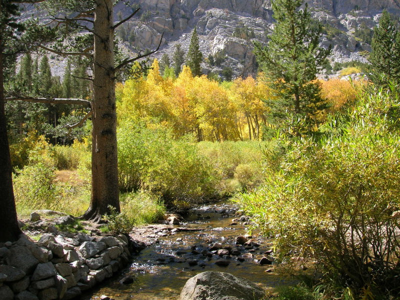
Second Crossing Of Bishop Creek
Happy birthday to me! I'm 42 today, and my brother has graciously given me this trip...paying for the
rediculous gasoline bill incurred on this 700-mile weekend. We're hiking up the Piute Pass Trail
past aspens that have turned a bit early. The air is cool but not cold, and we make quick progress
up the familiar trail.
We intend to take a shortcut from Piute Lake up into the southeast corner of the Humphreys Basin. A
bit of reliable beta obtained from a reputable source has encouraged us to try this route. It should
chop about 2 miles from the journey to our campsite.
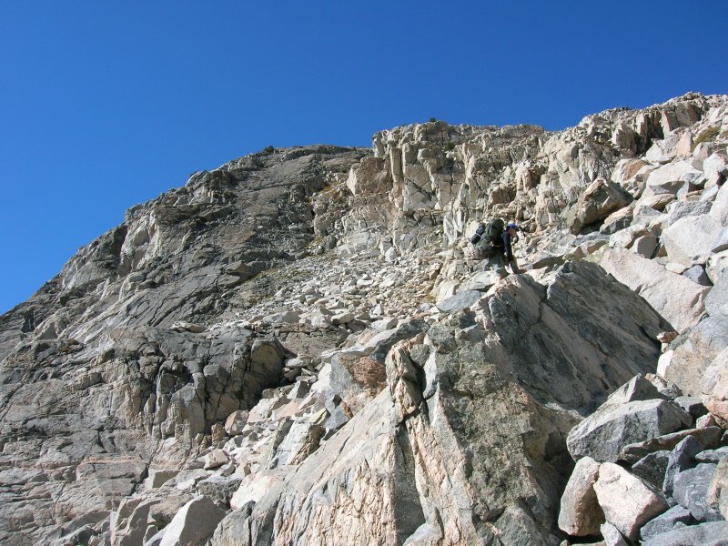
Climbing Towards The Humphreys Basin

Piute Lake
The shortcut is arduous, and we are only half convinced that it is really saving us time and effort.
No matter. It's a beautiful alternative to the dusty old trail up to Piute Pass. My brother leads
the way, and after a short break he takes us up a solid class 3 formation that splits a canyon filled
with loose talus and scree.
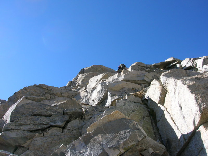
Clean Class 3 Cross Country
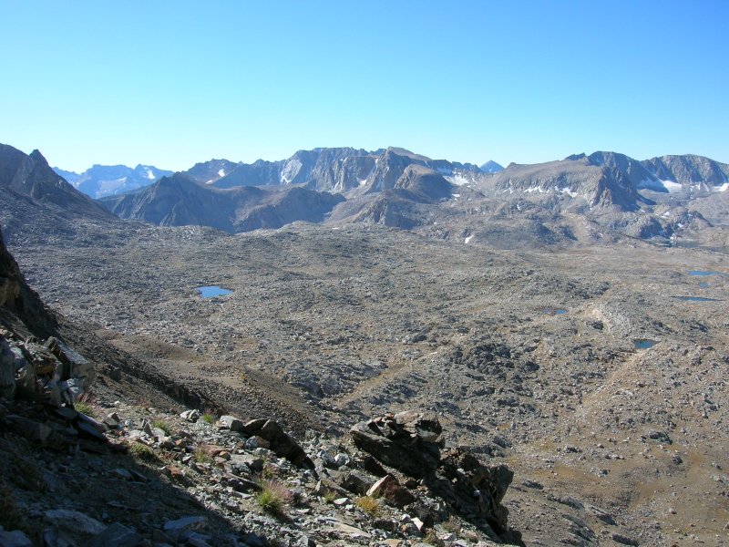
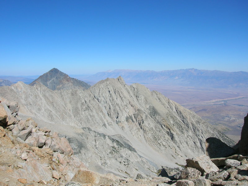
We get our first sight of Mount Humphreys as we crest the broad ridge and enter the basin proper. It's
a stunning sight, and we feel energized for the final stretch to camp.

Mount Humphreys

Small Pond In Humphreys Basin
Travel through the basin is very rocky, and there are small ponds everywhere. We wander around, ever
closer to the base of the mountain, and settle on a camp near one of the many larger lakes in this
part of the basin. We're both feeling those first-day-in-the-mountains, non-acclimatized blues. Not long
after dark we're both sawing logs, dreaming of ropes and fine granite, lichen and sky pilot. I arise once
durring the night to take a pee, and I'm flabbergasted (as always!) at the lack of blackness in the night sky.
There are stars filling every patch of space, painting the dome of heaven a beautiful silver-grey.
Sunday
We get a relatively early start...not 'alpine' but much earlier than our last attempt to climb this
peak. The huge scree field at the base of the peak is just awful! Last time we did this, it was an easy
snow hike directly up the slope. This time, we gently ascend on a long traverse, aiming for the bottom of
the initial chute leading through the black cliffs.
The World Is Falling Away
Horrible sand and scree infest the interconnected chutes low on the mountain. We manage to bypass nearly
all of the loose stuff by following class 2-3 ledges. The world quickly drops away behind us. Before long
we reach the notch on the Sierra crest, where we take a nice break. The weather is perfect! I had
expected a fierce wind to greet us upon reaching the notch, but there is barely a whisper of breeze.
View North From The Notch
(Mount Tom (L) and Basin Mountain (R) nearby, with the White Mountains in the background)
The class 3-4 section above the notch appears quite stern when viewing from below. We start up the northwest
face, Sean with confidence, I with trepidation. The difficulty slowly ramps up, traversing across and scrambling
up easy ledges. The 'face' becomes a chute with parallel cracks running up the bottom. The climbing is
in the upper level of class 3, but on very solid rock. As we near the 'pocket' - an alcove beneath a wall,
with a rappel station - we pass a single sky pilot in a recess. The blue-purple of the flower is framed
beautifully by the light orange granite! Wish I had time to take a picture.
I suppose there are a few options for exiting the pocket and progressing upward. We select what is probably
the easiest, if most exposed, option. A series of sloping ledges lead up and to the right, out onto an arete
dividing the northwest 'face' (chute) from the southwest face (a true, vertical rock face with some appreciable
scale). The moves out of the pocket are secure, but the exposure causes the adrenalin to flow!

Climbing Out Of The Pocket
We work our way up and out onto the top of the arete. Gazunga! What a perch! We gain a ledge/terrace on the
arete, and even though there is ample room to stroll around, I find myself facing the rock and clinging for
dear life.

View Northwest From The Big Ledge
(Photo from Sean's August attempt)
Sean leads off the ledge and up the arete. I watch as he becomes more fearful and cautious. He makes some
scary-looking class 4 moves and takes a rest, straddling the sharp arete. I'm positive that I will want a
belay to get up this section! He disappears and finds a suitable belay, then throws the rope down.
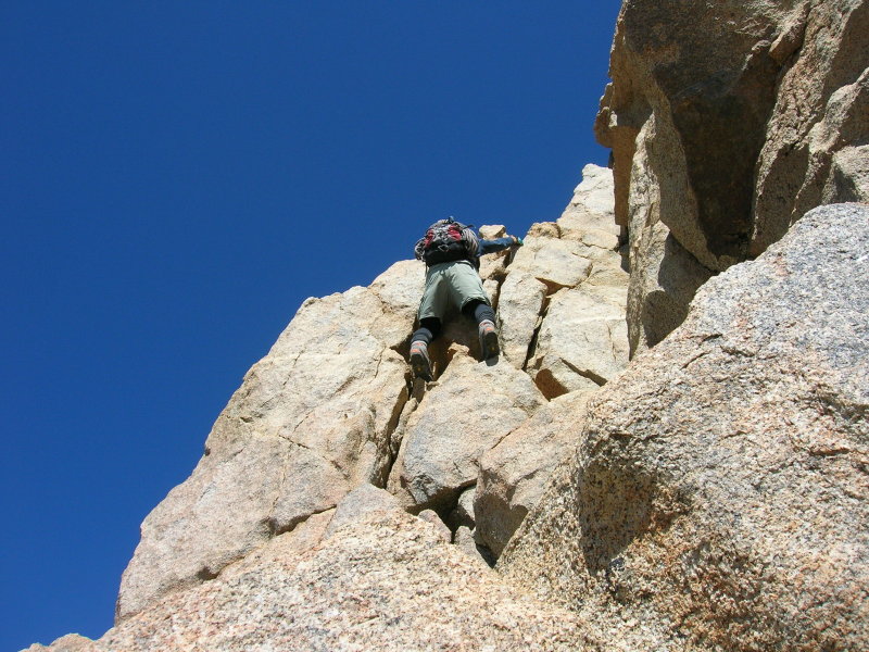
Sean Makes A Move
The belay is in a shallow bowl near the top of the northwest face, below the final talus slope accessing the
summit. I climb up to his belay, on eggshells the whole way, and settle in. It's a very short pitch, mainly
to avoid rope drag. I tie in, and Sean continues to lead. At the very top of the face, he scrambles across a
block that looks like a sofa balanced on two coffee cans.

Second Short Pitch Atop The Northwest Face
I avoid the sofa-block and climb up a more difficult, but more secure, corner to the left. We've done it! The
hard part is over, and it's just a nice walk up the talus from here. Well...almost. The final moves up to the
summit are some dang scary class 2. But finally we're sitting on top of the world.
This is the most airy summit I've ever had the pleasure to climb. There is an incredible amount of empty space
in every direction. The nearest summit of similar height,
Mount Tom at 13,652 feet, is several
miles north of us. The sharp crest of the Sierra Nevada snakes away north and south to lower summits. Even
nearby Mount Emerson, at 13,225
feet, seems like a minor peak from this vantage.

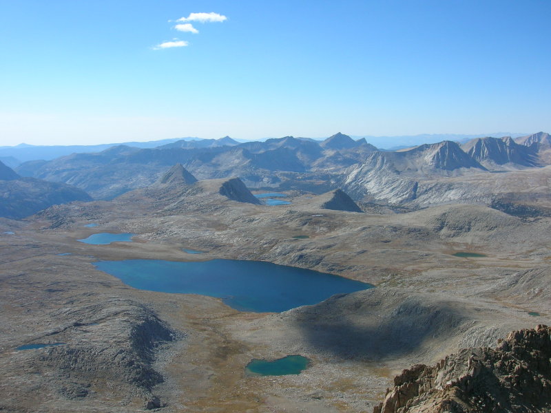
View Down Southwest To Humphreys Lakes
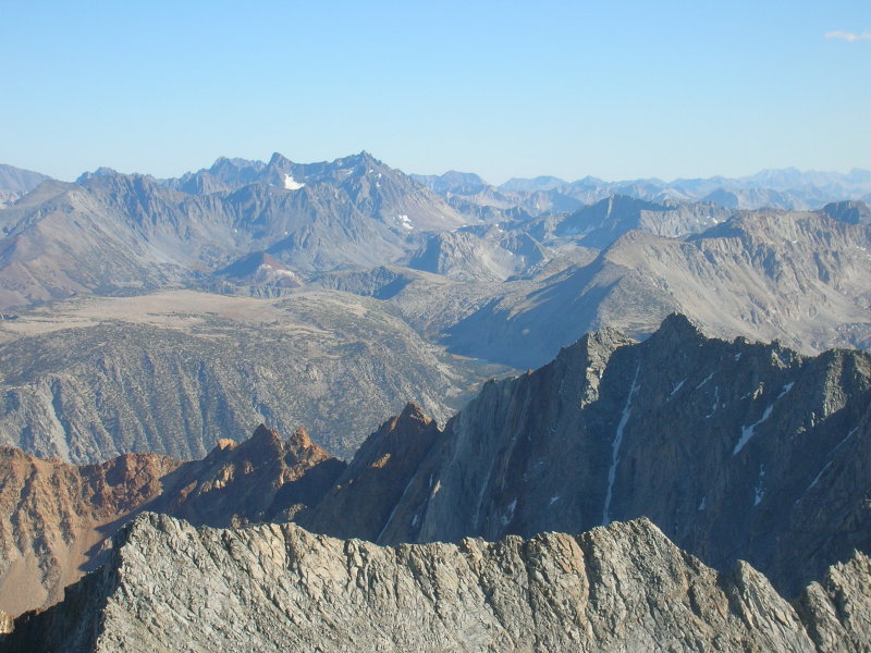
View Southeast
(Mount Emerson is right midground, with narrow couloir. Palisades are center background)
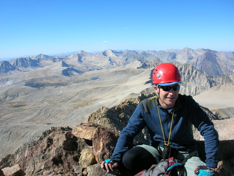
Sean On The Summit

HAPPY BIRTHDAY TO ME!
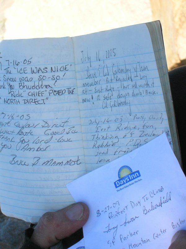
Name-Dropping
The Chief signs in (upper
left) after climbing the couloir a few years ago, and
SP Parker (lower right) signs in, presumably after guiding a client to the summit earlier this year.
View Northwest
(Desolation Lake is at center foreground)
We spend about 45 minutes on the summit, having a snack and enjoying the view, and resting. The lengthening
shadows prompt us to pack up and go. On the way up, we took the more difficult but less exposed southwest side
of the summit block. We descend the easier but far more exposed northeast side. A frightfully narrow ledge
slants down off the summit, with a 60-foot gap down to a rubble-strewn ledge below. Beyond that is the sheer
northeast face, too horrible to contemplate. We walk down the talus field and rope up at the top of the northwest face for a short class 4 scramble down to
the first rappel.
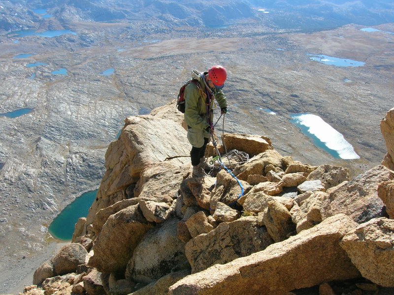
Sean Ropes Up For The Descent
We scramble down to the first rappel station. There are a pair of rusting pitons, probably older than I am,
slung with a variety of slings and cordelettes. We string the rope and Sean goes first. Then it's my turn. I
positively HATE rappelling! It's the most frightening part of rock climbing for me, depending on a single
rope, and in this case a single rap ring. And especially in this case, depending on those rusty old pins that
have weathered so many freeze-thaw cycles. I whine incessantly, and Sean is understandably nonplussed by my
griping.

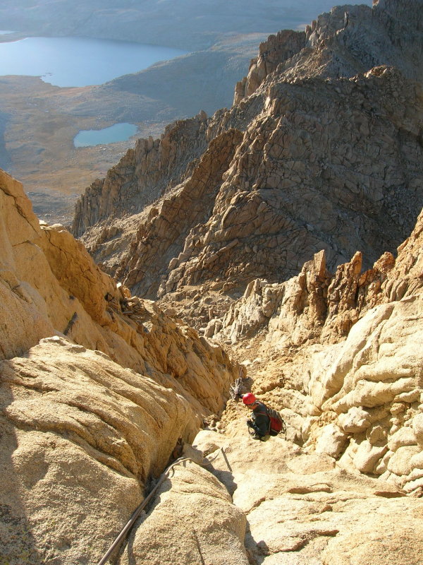
First Rappel Down The Northwest Face
We reach a good ledge and decide which way to go next. We can downclimb or rappel the same way we came up, or
aim for a spider-web rappel station below and to descenders' right. We choose the rap, which sports a gentle
overhang as it drops into the pocket. Sean endures more of my whining as I talk myself down into the pocket.
The station in the pocket sports another rusty old pin, and a nice flake to sling. We rig the third and final
rappel down the chute. This one is much easier, and we probably could have downclimbed this section. Better
safe than sorry.
Final Rappel To The Notch
We finish the rappel and bid farewell to the technical difficulties. A short scramble brings us back to the
notch, and the scree slog down the chutes on the southwest face.

Looking Back At The Northwest Face
The descent goes quickly, and before long we're enduring the horrible scree field at the base of the mountain.
Sunlight is fading, and I barely make it to the floor of the basin before dark. Sean is way ahead at this
point, and makes it back to camp in time to put a light on a nearby rock...a faint beacon to guide me home.
Now we have the pressure of schedule. We're both supposed to be at work on Monday, so we only rest for a
short while. We pack up in the dark, as the moon rises, then head off roughly in the direction of Piute Pass.
Here is where we find out if the Piute Lake shortcut was indeed shorter. The wandering through the slabs
of the basin seems endless. On and on and on. The shortcut was definitely all that! We make a slight navigational error
and end up too far east before reaching the pass. A little correction brings us back on track, and we finally
hit the trail right at the pass. Ahead is the mindless slog down the dusty horse track.
Normally I'm the slow one, and when I'm tired I really lag behind. Tonight, Sean is suffering fatigue. I'm able
to easily keep up. He calls it quits somewhere above Loch Leven, and we bivi near the trail. This is a good
call, because I'm about out of gas too. The cold wind picks up, and we both are glad to be out of it. At first
light, we rise and pack quickly. A beautiful and breezy morning passes as we zoom down the trail to North Lake.
The adventure is over! What a marvellous way to celebrate my 42nd year on this planet.
Thanks, Sean!!! You've helped me keep my sanity for yet another year.
FIN!
|


Comments
Post a Comment