
|
|
Mountain/Rock |
|---|---|
|
|
34.16470°N / 117.1588°W |
|
|
4743 ft / 1446 m |
|
|
Overview
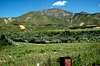
If you are in the Los Angeles area, and looking for a relatively easy, spontaneous day hike to a nice summit, this is the place. Just inside the San Bernardino National Forest, north of the 10 and east of the 330 freeways, a quick pace will get you to the top in a couple of hours. The start elevation is around 2000 feet, making the actual vertical climb around 2700 feet. From the summit you can enjoy panoramic views of the industrial San Bernardino Valley, as well as the surrounding peaks in the San Gabriel, San Bernardino, Santa Ana, and -- on a clear day -- San Jacinto mountain ranges. Look for the flag and climbing log in the plastic Spiderman lunchbox at the top (thoughtfully placed by a local repeat climber). Wildflowers aplenty grace the slopes in Spring, and right now there are striking charred husks of trees due to 2004's brush fires.
 |  |
Getting There
According to entries in the log book, it sounds like there are several ways up. I took the ridge that comes down southwesterly from the summit, which is marked as a firebreak on the USGS maps, following the north side of Cook Canyon. The actual summit is along the ridge to the north, but the good views (and the log book) are found on the east-west ridge to the south that is the head of Cook Canyon. Take the 10 freeway to the 30 North. Exit and head east on Base Line Road. Turn left/north on Church Street and shimmy your way through a residential neighborhood to the end of the Street, where I left my car for the duration of the hike. I then headed northeasterly along a dirt access road on the south side of Cook Canyon, until I found a reasonable place to cross over (at about the 2400ft line on the USGS maps). From there, I hit the ridge, and followed it straight to the top. There is some significant bush-whacking at the start (particularly in a rainy spring), and it gets rather steep towards the top, but either a slow pace or frequent short rests are more than enough to compensate.
Red Tape
Permits are required for the parts of the National Forest "that require admission fees." I would think that a quick day hike to the top and back in this part of the Forest would arguably fall outside of that grouping, but I don't know for sure.
When To Climb
Snow rarely sticks to this mountain, as it is usually just under the snow line, and it enjoys the relatively mild weather of the surrounding Los Angeles area (with due compensation for its relatively inland and high desert characteristics). The climbing log contains entries from pretty much all seasons, with temperatures at the top ranging from the 60s to the 90s (fahrenheit). I was at the top in early March, and the conditions were lovely (high 60s and sunny). I would give this mountain a year-round climbability rating.
Camping
Not sure if camping is allowed or not. Nice flat ridge/saddle configuration at the top, very conducive to tent set up. Definitely no built structures of any kind. See the Red Tape section for fee considerations.
Mountain Conditions
General information about the San Bernardino National Forest can be found at the USDA Forest Service site at:
http://www.fs.fed.us/r5/sanbernardino/