
|
|
Route |
|---|---|
|
|
42.24425°N / 73.33494°W |
|
|
Hiking |
|
|
Spring, Summer, Fall, Winter |
|
|
Less than two hours |
|
|
Walk-up |
|
|
Overview
At 2.3 miles round-trip and only 760' of vertical gain this trail is more about relaxtion than testing your fortitude. A simple class 1 hike, it provides a great introduction to hiking for young children (ages 3 and above) or for people looking to get away for a couple of hours.The trails will take you through pine and hardwood forests, past a seasonal waterfall with a hidden cave, to a summit characterized by plunging cliffs and impressive views.
Getting There
See the "Getting There" section on the main page.Route Description
The hike described here is a loop and can be done in reverse.The open and obvious trail is located to the right of the trail sign. The Hickey Trail heads north and is blazed white. At first (1000') the trail is wide and flat but as the trail turns to the northwest it begins a moderately steep climb. You will gain 600' in about 1/3 of a mile. As you climb, keep an eye out for a small waterfall that hides a small, indiscrete cave that can be used to relax and enjoy the sounds of the forest if the trails are crowded.
At about a 1/2 mile the trail abruptly changes direction going from the northwest to due south. You will go up and down over the next 500' until you reach a juntion of Squaw Peak and Indian Monument Trail. To reach the summit continue south (left) on Squaw Peak Trail.
You will continue your climb up stone steps and shelves of ledge for the next 300 vertical feet.


After taking in the views continue to rock-hop south toward the Devil's Pulpit. As you travel across the quartzite cliffs, taking care not to come too close to the leadges, plenty of opportunity for some minor class 2 scambling and sliding is available. However, for those who find the edges too precipitous, follow the white blazes occasionally peaking out off the ridge.
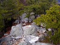
After passing the pulpit the trail heads back into the woods and begins to decend off the western side of the mountain, losing 300' feet in less than 1/4 mile. As the trail levels out you come to the junction with Indian Mountain Trail. Turn left and continue south on the very open and wide path. After another 1/4 mile of easy down-hill hiking the trail turns left (north) for the final 1/2 mile. The trail skirts Route 7 and brings you through large boulders that are either glacial erratics or portions of Monument Mountain that have fallen over the years.