The signature pic is by Kadee
The Henry's and I
I must admit to a love affair, a very sordid one at that. I'm in love with a mountain range (one of many however) that is located in an isolated part of Utah and was the last mountain range to be truly explored in the continental U.S.A. The history of the range fascinates me as does where it is located. That mountain range is the Henry mountains, located south of Hanksville Utah, and east of Capitol Reef National Park. It is basically a range dominated by five mountains, Mt. Ellen, the highest and most sought after one in the area, Mt. Pennell, Mt. Hillers (the object of my lust on the 12th of May), Mt. Holmes and Mt. Ellsworth. These five mountains all are nicely represented on the top 100 Utah prominence peak and Mt. Ellen is one of Utah's eight ultra peaks. If you don't understand or care about prominence, that is not a problem, but once you get involved with exploring this mountain range, the Henry's will have you in their power. Two other mountains also are worth a visit, Bull Mountain and Raggedy Mountain. Those two I have yet to visit but they are high on my to do list.
My wife is aware of this other competition but she is not jealous, she is not envious and she would like to get to know this mountain range better herself.
This summer may be her first foray into the area and camping out at Starr Springs, Lonesome Beaver and McMillan Springs will test her beyond her normal camping choices. Summer of 2010, bring it on. Now onto the visit to Mt. Hillers.
The Plan
Andy Martin of Tucson Arizona and I had emailed back and forth about a joint effort so we could both finish up the five main peaks of the Henry's. Andy had already visited the summit of Mt. Ellen and being a prominence chaser like myself, he was very interested in the other peaks in the Henry's that had over 2000 feet of prominence. With the exception of Mt. Pennell, which he would do by himself, we teamed up for Hillers, Holmes and Ellsworth. We also did three other peaks later on during our week together, the last one a fitting 21 mile hike to get to the summit of Mt. Elliot of the Book Cliff area.
I was to meet Andy at the Starr Springs campground on the evening of the 11th and then we'd tackle Hillers, followed by Holmes and Ellsworth. I drove down from Lehi, figuring on about 4 hours to make the drive to get to the campground and with a stop in Green River for gas and food, that turned out to be right on the money. The unusual thing was that not ten minutes after I had reached the Starr Springs Campground, Andy arrived. That was absolutely amazing since he had driven all the way up from Tucson, easily an eight hour drive or so for him. It was great to see Andy again, I had climbed a couple peaks in the west utah desert with him and a couple of his Arizona friends, both great guys, when we did George Hansen Peak and Graham peaks, both prominence peaks that we were all happy to get. George Hansen Peak was a tough day but I found out that day that I really liked not only Andy but his two sidekicks.
Andy might be called the "father of county highpointing", another fun arena of people like myself and while Andy will humbly not take all the credit for starting such an adventure avenue for peakbaggers seeking something different, his book is certainly the 'bible' for county highpointers. I would recommend it if you should become interested in doing county highpoints. Utah has about 40 people who have touched the top or the highest point in all of its 29 counties and it is a pursuit that takes a person to every corner of the state, often places very isolated and unknown. Mt. Ellen is one of those county highpoints but for those of you who want me to get on with this hike, I will move on.
Mt. Hillers
![Topo Route]() Greg's map
Greg's map
Andy and I discussed our agenda and we agreed to do Mt. Hillers first. We spent a pleasant evening at the campground, talking right up to the time when it was time to get some shuteye. In the campground, a nice little one, tucked away in the middle of nowhere, there were only a couple of campers. Equipped with running water from the namesake springs, Starr Springs is a place I could easily return to again and again.
Up bright and early, Andy and I utilized my truck to make our way about 11 somewhat rough and often bumpy miles to a spot where Kadee suggested on her Hillers Peak page. In fact, thanks to
Kadee for
her information and pictures she provided, it was a lot of help to Andy and myself. We were to hike with Kadee many days later when we did Mt. Elliot with her, a 21 mile hike that we enjoyed together. She is a great hiking companion but again, her page was very helpful as we pretty much followed her route up the mountain.
From where we parked, we walked up a no longer used and washed out in many places road that used to lead to a mine that is no longer operational. Having a road made the early section of the hike pretty easy and we gained elevation easily and steadily as we hiked along its length until we reached a saddle. Cass Creek had some water flowing in it and had we needed to get water, it would have been a good source. My GPS said it was right around 1.5 miles to the saddle and that was where the road ended, although it did turn south and head for where the mine was located. However, there were many trees down across the road and that made it slow going. We eventually just cut off the road and made our way up the slope, with Andy picking his way up it and myself picking mine. We both met on the ridgeline that would eventually lead us to the summit but I should add that from where we parked to the pass, there was an elevation gain of close to 1500 feet.
![Looking north]() North
North
From the saddle to the summit is roughly three miles with another 2000 feet of elevation gain. I can't exactly describe the route but the best thing to do would be to aim for the main ridge that is on the west side of the road after you get to what I keep referring to as the saddle. Once we left the road, there is no trail, just common sense direction finding and with the
information that Kadee provided on her SP page, it was pretty straightforward. To get to the north ridge, we had to ascend a talus section that was an area where we paid attention to our footing. Lots of the talus moved so we didn't want to twist an ankle and mess up the rest of the week by doing so. Once on the ridge proper, the going got easier and while a few sections were steep, it was never technical or overly difficult.
Greg had created a nice map that we used, found on Kadee's page and in reality, that is about all we needed although it always helps to have the summit GPS'd as a coordinate. Hillers was a great start to the week for Andy and I as we hit it off and climbed well together. It was going to be a good week.
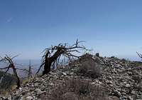
When we got to the final summit ridge, it was interesting to see lingering snow banks on the south side of the ridgeline. The summit itself was kind of no big deal but a glass register container, was tucked away in the summit cairn was what we were looking for. The views were excellent although a bit hazy. My favorite view was looking north, back up towards Mt. Pennell and Mt. Ellen, both mountains I had already made an acquaintance with and had really enjoyed. Mt. Ellen I had hiked with my son in law Andrew and good friend Dennis Poulin and Mt. Pennell i had done the summer before with my son in law Andrew. I know I will need to return to Mt. Hillers someday so my son in law can get the summit as well. I will include Cass Peak on that visit. Anyway, after Andy and I signed the register and grabbed a bite to eat, we took time to enjoy our surrounding and appreciate this mountain. Then it was time to descend. I noticed in the register that Greg had completed the five major prominence peaks the year before and since then he has also done Bull Mtn and Raggedy Mtn so as of this moment, he is the only one I know who has done this many. I'd imagine that Mike Kelsey has done those as well and I should mention that
Mike Kelsey has a
neat book on the Henry Mtn range that you can and should utilize for information on the range and the peaks.
On the way down we pretty much followed the ridge as we had on the ascent but thinking we might avoid that talus field we had encountered at the beginning of the ridge, we opted to go off the ridge a bit early and hopefully discover a bypass to that talus. Well, that turned out to be a minor mistake as we ended up with some brush and steep slopes to deal with but while I would stick with the ridgeline all the way down next time, it added a bit of spice to our overall hike. Once on the mine road again, it was like being on the freeway all the way back to the truck.
![Time to go down]() Heading down Heading down | | ![We re parked down there]() Trailhead Trailhead |
Andy and I returned the bumpy miles back to the campground and were reminicing about the day as we sat at our camp table when an older gentleman from Texas pulled up and asked if he could join us. That turned into another adventure but I'll skip the narrative of the "colorful" experience.
All in all, it was a great day and the next day, we would get to know Mt. Holmes very intimately.
One last word: Thank you Mt. Hillers, I know I'll be back.
Andy Martin book
If you are thinking of or are interested in the USA county highpoints,
here is a useful resource:
County Highpoints by Andy Martin 126 pages of lists covering every state in the union. Available from Andy at:
Old Adit Press
3030 N. Sarsaparilla Pl.
Tucson, Az 85749
Price was 12 bucks which I believe included shipping.
Andy Martin
An interesting read about how Andy inspired him to begin his Washington effort
From Peakbagger dot.com comes this reference to his book:
County High Points by Andy Martin
In compiling the lists for this site, an extremely valuable reference work was a book called, simply, County High Points. This spiral-bound "bible" lists the highest points of all 3,141 counties in the United States, plus the most prominent peaks in virtually all mountainous areas of the country. It also contains unexpected goodies such as a list of Mexican State high points and U.S. National Park high points, plus a nice explanation of the prominence concept.
Next: Mt. Holmes
FIVE DAYS OF HIKING
Day one - Mt. Hillers
Day two -
Mt. Holmes
Day three -
Mt. Ellsworth as well as
Land's End
Day four -
San Rafael Knob
Day five -
Mt. Elliot
Comments
No comments posted yet.


 West
West South
South East
East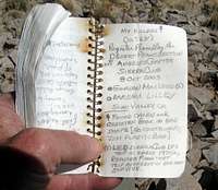


 Heading down
 Trailhead