Decisions... Decisions...
![Alice Lake Pano]() Alice Lake Panoramic
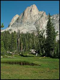
Alice Lake Panoramic![Sawtooth 2008]() El Capitan
El Capitan is a site I frequent occasionally which contains a nice message board to read about fellow members' accounts, to ask questions of more seasoned folks regarding routes, and whatever else may cross a member's mind to type. There had been earlier outings arranged, however I was unable to make those trips. Most recently another outing was scheduled to occur on September 11th, (the day after my b-day) to climb El Capitan in the Sawtooth National Recreation Area which made for an interesting quandary.
For the past two years I have been doing something like a dayhike for my b-day. In fact I had contemplated the thought of dayhiking McGown Peak in the Sawtooth area since the decision was mine of what I wanted to do for my B-day. Every intention was made the night before to awake at 4:00 a.m. to dayhike and bag McGown Peak, however when McGown day came, my bed was just too damned comfortable for my (now) 36 year old arse, and the 4:00 a.m. departure time soon came and went. An Owyhee road trip and a jaunt through 'Art in the Park' were the staple of my b-day this year. However, in hindsight I do not have much animosity towards myself for letting that hike slip by because it gave me a decent opportunity to meet the Idahosummits group and to claim a peak I have always looked at with longing eyes...
Note: The El Capitan pic to the left and pano shot above were shot on a different occasion. Meeting the Group
Waking at 4:00 a.m., I was out the door and on the road by 4:30 a.m. It had been awhile since I had done a solo road trip, so I was anxious for the drive to Stanley.
![The Idahosummits 2010 Fall group]() Group Photo
Group Photo Since it was September, the sun wasn't rising until around 7:00, which left a lot of driving in the dark. After a close encounter with a deer, I cranked up the music and zoned out until Stanley. Arriving in town around 7:30, there was a lot of haze still hanging about. In fact, I couldn't even see the peaks of Thompson, Williams, or Heyburn because of the thick fog enveloping them. I wasn't too concerned since the forecast looked good and I saw the blue sky greeting me before driving through town.
Arriving at the Tin Cup parking lot I could see a couple campsites coming alive from the overnight hibernation. It was a brisk, foggy morning and from the looks of the (stiff and slow) people, it must've been a cold one that night too. I rolled through the parking lot and found a spot close to the trailhead and parked. While eating I looked at my clock, 7:50 a.m. I then caught site of a white and tan Subaru barreling into the parking lot as if they had a patient in the back arriving at a hospital emergency room. Fortunately the 'patient' would be Steve (Deltaoperator) and the only harm done was a concerning case of road sickness, apparently caused by Splattski and the thought of missing the 8:00 a.m. rendevous time. After meeting Steve, Splattski, and Dan, I quickly came to the realization that my decision to come on the trip was a wise one. These were good and genuine people who shared a passion for hiking and the outdoors. What fun!
Soon after kicking the dirt for a bit, other's started making their way to the trailhead. Among those were John F and his son Dylan, Pam, Margie, Margo, and Bella whom I assumed all traveled from the Pocatello area. Dave is also from that area which I calculated from his 'Bengal Nation' attire. (GO ISU!) Coming from the Parma area was Jacob, who later showed his fearlessness among El Cap's cliffsides. John P. and Dan being from the Boise area, with Steve W from Caldwell, and me from Nampa. It seemed like there were a good amount of people to keep the conversation flowing and the laughs often among the 12 of us...
The Hike
![Pettit Lake Reflection]() Pettit Lake Reflection
Pettit Lake Reflection
Starting the hike around 8:30 a.m., the trail follows Pettit Lake for about a mile before climbing in elevation and meandering away from the lake and through the forest. Soon the fog was burning off of the lake to reveal a beautiful mirror-like reflection. After a short photo op, the temperture started to rise a little. Within moments, layers of clothes were being stripped off due to the blood finally moving from the nip of the morning. Once at the permit sign-in point, Jacob volunteered to sign in for the group and wear the tag.... then the jokes started. (Jacob was now willing to take the fall for whatever ANY of us decided to do in the area, good or bad). It was nice to see a large group come together and have a good time with light hearts. During this time I kept rather quiet, just listening to all the intriguing conversation happening around me. From Splattski's advise on climbing Mt Rainer in the snow, to Steve's talk of Backpacking entree's and his new book coming out soon on cooking. I can honestly say I was quite content without saying a word and being in the presence of such interesting people.
Soon we were in front of a creek crossing, which was one of many we would come to. This one required a steady foot while 'rock-hopping' across several large boulders in the middle of a stream. Luckily there were no wet feet until after we summitted, but I won't mention any names for the sake of anonymity. :P
![B&W Whiteclouds]() B&W Whiteclouds
B&W Whiteclouds![Dad & Son]() Dad & Son
Dad & Son
I did notice on one of the creek crossings how slick the log we happened to be on was. Apparently the frost doesn't care if we need to use the log or not as it stayed providing a nice, slippery surface for us to be cautious with. Thankfully we were unscathed and proceeded forward. Once out of the canyon floor the trail starts following a granite field coming off the backside of Parks Peak. I have done these switchbacks a few times before and can say this was the most pleasant time I've had on them. In the past they had been so hot and miserable, but today offered a comfortable setting for the trek. Once through the granite switchbacks, the trail crosses a bridge then hooks back towards the Whiteclouds, offering a stunning view. I especially liked the shadowing revealed in the B&W photo shown to the left.
The Climb and the 'Pucker Factor'
![El Capitan]() El Capitan
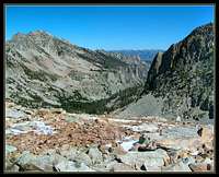
El Capitan![Talus Galore]() Looking down the Talus Field
Looking down the Talus Field![Ridgeline]() The Ridgeline to the Summit block
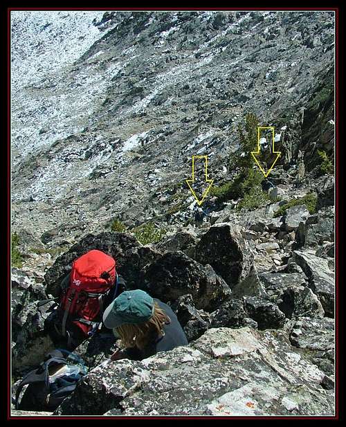
The Ridgeline to the Summit block![Talus Field]() Talus field before the 'real' climb...
Talus field before the 'real' climb...
After a short break, we got back on the trail which offered a closer view of our destination, El Capitan. We broke trail and made our way passed a small, unnamed pond under the peak, then over a short, grassy shelf towards the dreaded talus field... From this point we just made a line and followed it up. It was nice having the guidance of John and Dan to help create the route we all took. Along the way we set our own individual paces. In fact Jacob was making the best time by making it at least 30-45 minutes before the rest of us. The rest of us took our time and plugged our way through the rocks until reaching a south facing cirque, and a small ridge leading to the summit block. After several breaks while feeling a little lightheaded from the altitude, we were finally nearing our destination. Once to the top of the ridgeline, the views started becoming the typical, picturesque jagged peaks the Sawtooths are known for. I was finally directly below the summit block with only 20-30 feet more until the top was mine. Unfortunately there was an interesting traverse in my way. At the time it seemed like a knife edge leading up to the summit block, and to my surprise the 'route' was leading over a
very airy staircase to heaven situation.
Now I'm going to be quite frank with you, the reader, about a little phobia I have. I cannot stress enough my fear of heights, which is a little ironic. Couple the stress of this little phobia with my 'now cramping quad and calf' and I'm becoming a little concerned. I can recall sitting for what seemed like a good 10 to 15 minutes contemplating what the hell to do. I decided it was now or never and got in line behind Pam. I turned my attention upward, finding the imaginary line.... MY imaginary line. Pam then turned and asked me what route the others took and I pointed to the 'staircase' I saw before us. The response I received was:
'Are you Serious?'
In reality I probably had nothing to worry about, but the vivid words repeating themselves in my mind were 'three points of contact, three points of contact', while the visual of falling 800ft to my death replayed itself everytime I blinked. I guess I really am not as afraid of falling as I am of hitting the ground afterwards, however I think it's a good idea to have neither happen.
Later conversation would confirm my thought of this being borderline Class 4, who knows, maybe I'm reaching. I look at the scenario now and it was fun. Maybe I'm telling the truth... maybe not. All I know is there was alot of distance between me and the ground and there was some 'puckering' going on down south...
![The Ascent]() The Ascent
The AscentThe Top
Once reaching the top the views were amazing, especially towards Snowyside Peak. Amazingly all 12 of us fit on the summitblock while soaking in the scenery. Some people ate lunch, some were taking pictures, and surprisingly Bella was able to pull off a yoga pose on top. In total, we spent about 30 minutes on top before we randomly began to depart. John was tending to his flock while we descended into a safe area, then the gruelling downhill we all love and hate began.
![View from El Capitan, Idaho]() The view from the top
The view from the top
The downhill was rather uneventful. On my part, I was relishing in my own personal glory for bagging this wonderful peak. On occasion I could feel my leg tighten in a slight cramp, but I would stop quickly and it would cease. After a short while we finally made it down to flatter ground, which soon led to the trail. It's always nice to get back on a well traveled trail after bushwhacking for a few hours. Funny how it seems like a freeway while the pace really quickens. The highlight of the downhill was watching Bella take a digger in the creek while we were taking a break. At this stage in the hike it probably wasn't necessarily a bad thing since we were all ready to get down. This 'footbath' break ended up being the last 'rest' we would have. The switchbacks flew passed us and the next thing we know the talus fields are behind us and we are surrounded by forest. Soon Pettit Lake was by our side again and we all just put our heads down and trudged through roughly the last mile without stopping. I think we were all ready to be done when arriving at the trailhead, I know I was. Nothing like sitting down after a long hike like that...
Overall I feel this trip was a great memory to reflect upon in the future. I'm thankful I was able to take part with the rest of the group and I was welcomed with open arms. I appreciate everyone's kindness and am looking forward to any other trips I may be invited to partake in with any of the folks in this group. Truly class acts, each and every one of them!
TRIP SPECS:
Miles:12.2
Elevation Gain:approx 2900 ft
Time:approx 10 hours
My Day:
4:00 a.m. wake-up
3 hour drive
10 hour hike
3 hour drive
3:30-ish a.m. sleepy time
The Map
![El Capitan Topo]() Ye' Ole El Cap Map
Ye' Ole El Cap MapLinks to Other Trip Reports
Margo -
http://mslasky.blogspot.com/2010/09/el-capitan-sawtooth-range-idaho.html
Dan -
http://idahosummits.com/trip_reports/trip_report.php?trip_id=15
John -
http://www.splattski.com/2010/el_cap/index.html
Steve -
https://www.summitpost.org/trip-report/661379/idahosummits-2010-fall-outing.html
Comments
No comments posted yet.