
-
 7507 Hits
-
 79.78% Score
-
 11 Votes
|
|
Mountain/Rock |
|---|---|
|
|
28.12207°N / 17.13799°W |
|
|
Hiking |
|
|
Spring, Summer, Fall, Winter |
|
|
2106 ft / 642 m |
|
|
Overview
 Jaragan above San Sebastian, the island capital of La Gomera Jaragan above San Sebastian, the island capital of La Gomera |
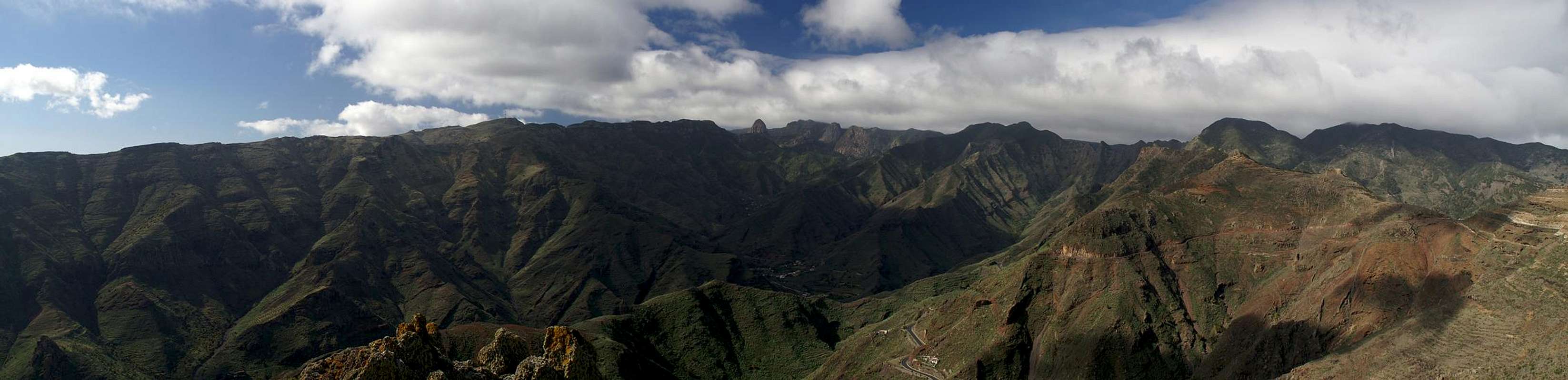
When travelling to the island of La Gomera you will most likely first touch its soil in the harbour of San Sebastian, the island capital. After taking in the few houses of the town your view will quite certainly drift upwards and touch upon the mountains that rise to the west of San Sebastian in the direction of the island centre. Probably the first mountain you will see will be a dark mesa, vertical on one side, almost flat on the other - the first mountain on a long ridge which heads out towards the island centre. This mountain is Jaragan, one of the best lookout spots in the north-east of La Gomera.
The mountain can be reached rather easily from San Sebastian. A short drive along the Carretera del Norte, the road, which connects the island capital with the northern town of Hermigua will take you to a hidden trailhead at km 8. A dirt road leads to a pass, La Gerode, which separates the long ridge of the Altos de Uteza from Montaña Ismael . A narrow path heads along a ledge of the Montaña and passes close by the Jaragan summit. Reaching it means scrambling through brambles and across loose rocks.
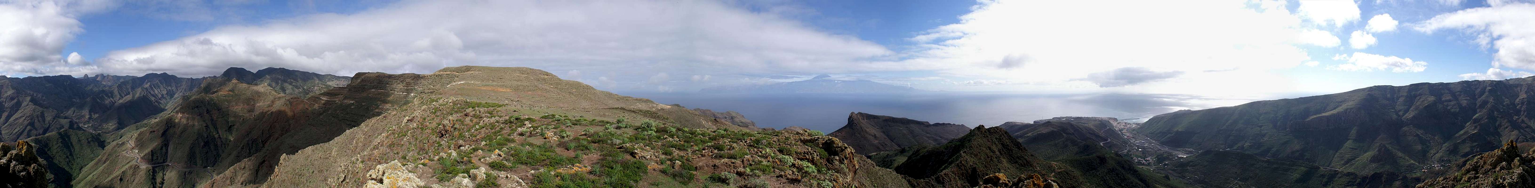
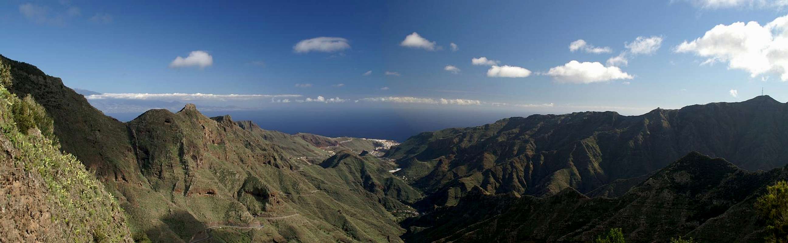
Jaragan offers beautiful views towards the inside of the island. Los Roques can be seen across profound barrancos and in the east San Sebastian is located right at the base of the mountain. Across the sea Tenerife
with mighty Teide hovers above La Gomera's east coast.
|


360° Summit Panorama
  |
Getting There
 |
In contrast to the large Canarian Islands, La Gomera and El Hierro don't have international airports. Reaching the islands therefore means switching to a local carrier at Tenerife (or any of the other Canarian islands) or use a ferry. Since weather is known to be unstable at the La Gomeran airport near Playa de Santiago, most travel offices will offer the ferry option.
Usually you will be able to book a flight to Tenerife South together with a bus transfer to the harbour at Los Christianos and the ferry to San Sebastian de La Gomera (bus transfer to your hotel on La Gomera is also included).If you want to travel on your own you can use ferries from either La Palma or Los Christianos and Santa Cruz on Tenerife.
The mountain - Jaragan - is located north of TF711, the road which connects San Sebastian de La Gomera with Hermigua. The trailhead is at km 8, right before the first of the tunnels through the Cumbre Carbonara Range.
|


Red Tape
 Almond blossom
Jaragan is just inside the Parque Natural de Majona. La Gomera has a lot of National, Regional, Local and Natural parks, basically sparing only the habitated areas. The Parque Natural de Majona is one of these and the usual restrictions apply. Don't leave roads or trails, take your refuse with you and don't disturb wild animals. Leave plants in their place. The area is used for sheep grazing and on neighbouring Montaña Ismael there is a shepherd's cottage with a lot of waste strewn around. Jaragan is quite clean and should remain that way.
Accommodation
 |
Of course you can find a lot of hotels, fincas and casas on the island which you can book from any travel office. The nearest town is San Sebastian de La Gomera, the island capital. Also,, Hermigua is only a few kilometres away, but on a very winding road. Both San Sebastian and Hermigua are not the typical tourist destinations, which you rather find on the south coast.
Weather Conditions
 |
There are few sites on the web, which deal with the weather for La Gomera. The island just is not very popular with the tourist crowd. The ones you can find are for San Sebastian, which is rather close to Jaragan. The following table gives a rough general overview over the weather on La Gomera, at sea level.
| Month | Jan | Feb | Mar | Apr | May | Jun | Jul | Aug | Sep | Oct | Nov | Dec |
| Avg. day temp.[°C / °F] | 20 / 68 | 20 / 68 | 21 / 70 | 22 / 72 | 23 / 73 | 25 / 77 | 27 / 81 | 29 / 84 | 27 / 81 | 25 / 77 | 23 / 73 | 21 / 70 |
| Avg. night temp.[°C / °F] | 15 / 59 | 15 / 59 | 15 / 59 | 16 / 61 | 16 / 61 | 18 / 64 | 20 / 68 | 22 / 72 | 21 / 70 | 20 / 68 | 17 / 63 | 17 / 63 |
| Water temp.[°C / °F] | 19 / 66 | 19 / 66 | 19 / 66 | 19 / 66 | 20 / 68 | 21 / 70 | 22 / 72 | 23 / 73 | 23 / 73 | 22 / 72 | 22 / 72 | 21 / 70 |
| Rainy days | 11 | 8 | 6 | 5 | 2 | 1 | 0 | 1 | 2 | 6 | 8 | 8 |
The Canarian Islands (as well as Madeira) are located in the trade wind zone. You almost always encounter northeastern winds which carry a lot of humid air. Being forced to climb to higher altitudes this moisture condenses into clouds. This in return means that most of the time the northeastern part of the islands is covered in clouds from altitudes of 1000m through 1500m.
The mountainous region in the centre of the island is of the same altitude and thus stops the clouds. While the northern parts of the islands can be foggy and rainy the southern parts most often are sunny and hot. On La Gomera the centre of the island collects almost all moisture in a big cloud forest, the laurisilva. It is the largest consecutive cloud forest on any of the Canarian islands and has been declared world heritage site.
Maps & Books
Out of the multitude of maps and books I have been using the following. However, so far I have not found a good hiking map of the island. The one posted here is ok but shows only a fraction of the marked hiking trails.- Maps
- La Gomera
Kompass Map WK231
Kompass Verlag
ISBN: 978-3-85491-015-2
Books
- La Gomera
Klaus Wolfsperger / Annette Miehle-Wolfsperger
Rother Verlag
ISBN 3-7633-4007-6 (German)
ISBN 3-7633-4823-9 (English)