
|
|
Mountain/Rock |
|---|---|
|
|
32.47638°N / 4.92802°W |
|
|
Mountaineering, Skiing |
|
|
Spring, Fall, Winter |
|
|
12293 ft / 3747 m |
|
|
Overview
Commanding the view above the High Moulouya plain rises a 47 kilometer ridgeline, half of which stretches uninterrupted above 3000 meters. Jebel Ayachi (sometimes spelled Ayyachi) is a positively massive mountain. “Aloof and lofty Ayyachi”, writes Michael Peyron sentimentally, she is “a queen among Morocco’s mountains”.[1] The lower slopes of the mountain show remnants of majestic cedar forests. Junipers persist but few living cedar remain, with dead standing trees obstinately upright, silver skeletons echoing an era when the climate was cooler and wetter. As one ascends, the northeastern aspects are guarded by beautiful cirques whose deep scars reveal the elegant geologic folds from the tectonic forces that pushed these mountains up. Snow lasts late into summer. As it melts, the sheer expanse of shattered shingle rock that covers the unimpressive summit dome can feel more like a dull hill – nevertheless the views up top are spectacular.
The slopes are imprinted with a crosshatch of trails that centuries, and perhaps millennia of grazing herds and their shepherds have trod. These mountains are rich with the history of the Amazighien (the Free People). Zawiya Sidi Hamza, below the southern slopes has been the seat of the Hamzawin holy men for half a millennium, one of whom is the massifs name sake – Bu Salim Ayyachi from the 17th century[2].
[1] http://michaelpeyron.unblog.fr/2010/11/12/aloof-and-lofty-ayyachi-a-queen-among-moroccos-mountains/
[2] Peyron
Getting There
Fes is the closest international Airport and the best starting point if you are trying to use public transportation. However, public transportation from any of the large cities (Marrakech, Casablanca, including Fes) will be exponentially more time consuming than hiring a 4x4.
Cirque de Jaffar
Use Google Maps to navigate to 32.654717,-4.966755 driving through Ait Omghar. From these coordinates turn south towards the Ayachi Massif on the forestry track. This track follows the north side of a dry river bed. Drive 16.5 km to where the track crosses Oued (River) Jaffar at 32.538466, -4.896201. There are settlements in the vicinity where you can park your vehicle. A small fee for them to guard the vehicle is well worth it.
Route
There are a number of different starting points that all converge on Tizi n’Tirecht (3,140 m) below Said ou Adi.
From the cirque de Jaffar head southeast up the Sbou (river) Tfernt through Taqqat n-Ijimi which is a narrow and spectacular gorge (about 3 km). Once through the gorge, the valley opens up to the southeast. Follow the trail along the true right bank of the Ijimi Assif (about 6 km). As you come close to Tizi n’Tirecht asend to the north (opposite Ayachi).
Once on the tizi, looking south, take the northwest ridge of Said Ou Adi. There are some rock bands that have easy class 2 scrambling. The final slope leads gently to Said Ou Adi which has a sign claiming to be the summit. However, the maps show this to be 3727 meters and it is the more impressive summit. But, the true summit, if you are wanting the highpoint, it is 20 meters higher and a 30 minute stroll northeast.
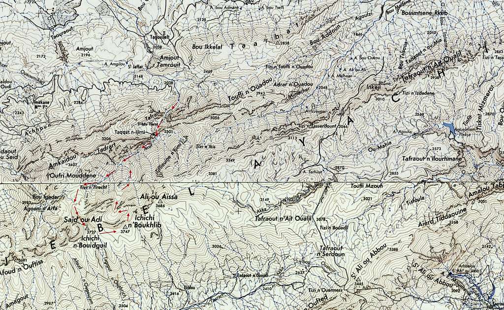
Descent: from Ichichi n’Boukhlib descend northeast in an arc down the steep bowl and let gravity guide you steadily toward the Ijimi Assif and then retrace your steps to the cirque de Jaffar.
Red Tape
No permits or fees required. No seasonal closures.
When to Climb
Mountaineering
March-May and October
Ski Mountaineering
January-February.
Factors to consider:
- There are no reliable water sources above the 2,200 meter contour.
- In winter avalanche danger is significant on the upper slopes.
- Most snow will have melted by late spring. But most years there are patches of snow hiding in the shadows on north facing aspects up high which you can melt if you are bivvying.
Mountain Conditions
Weather info - https://www.meteoblue.com/en/weather/week/jebel-ayachi_morocco_2556738
Because the lower slopes are shielded from the wet western weather systems by a high secondary ridge (up to 3400 m) there may be deceptively little snow down low. But beware of cornices and wind-loaded slopes up high. People have died due to avalanches here.
Camping
Taqqat n’Ijimi, with reliable water, is the gateway into the valley directly below Ayachi. Just past the gorge where the valley opens up is a small shepherd’s cave and flat grassy areas to pitch tents. You may be sharing the space with nomadic herders in summer.
Farther up the valley there is a flat grassy area to camp on the south side of the Ijimi Assif. However, there is no reliable water. 32°30'20.8"N 4°55'41.5"W
As of 2019, if a Moroccan sees a foreigner setting up camp they will probably call their local representative (the Muqadam) who will probably come to your camp site or wait for you at your vehicle to take your details, including a photo of your passport. In extreme cases they may require you to return with them to camp in the vicinity of their house under a streetlamp. Their intentions are good and they only desire the security and positive experience for travelers. The most conservative plan would be to get permission from the Gendarmerie in Midelt who may require you to contract a licensed mountain guide. You can also go without and plead ignorance.
There are no mountain huts.
External Links
https://pcmorocco1963-1972.com/2017/12/08/ayachi/
https://pcmorocco1963-1972.com/2019/03/26/jbel-ayachi-continued/
https://fr.wikiloc.com/itineraires-randonnee/jebel-ayachi-from-jaffar-13762784
https://www.youtube.com/watch?v=yOd32Yoqxug&feature=emb_logo ski ayachi feb 2019 but not first ski descent :)