
-
 15742 Hits
-
 93.35% Score
-
 42 Votes
|
|
Area/Range |
|---|---|
|
|
29.73900°N / 8.98674°W |
|
|
Hiking, Trad Climbing, Bouldering, Big Wall, Scrambling |
|
|
Spring, Fall, Winter |
|
|
7792 ft / 2375 m |
|
|
Overview
Jebel el Kest (Anti -Atlas)
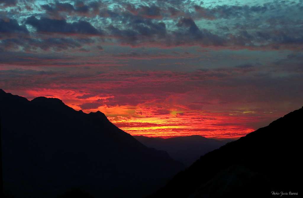
The Jebel El Kest Group is a fascinating range lying in the Eastern end of the Moroccan Anti-Atlas region, a wide and semi-desert land situated SE of the Atlantic coast, descending Southwards to the Sahara-Desert and crossed by a very long mountain range W-E oriented. To the North, the wide Oued Sous Valley separates it by the higher and well known range of High Atlas, beyond which it lies the charming town of Marrakech. This range takes its name from the mountain of the same name, the Jebel el Kest 2359 m, the highest summit of the group.
To the South the amazing Ameln Valley with its traditional ancient Berber villages separates the Jebel El Kest group from the desert lands beginning South to the oasis of Tafraout. The Jebel El Kest group is the most interesting and the unique developed climbing area of Anti-Atlas; being the orography quite complex, to begin we can split the region in two main areas: the Jebel el Kest North Side, which is located to the North of the main summit, and the Jebel el Kest South Side to the South.

The North side is well approached from the small village of Ida Ougnidif, while the South side is situated close to the beautiful oasis of Tafraoute, a nice town lying about 400 Km South to Marrakech and 170 km South-East to Agadir. The altitude of the town is about 900 meters. All the areas, both North and South side, offers many opportunities of hiking, scrambling and above all climbing on high and impressive walls and beautiful crags built in by an extraordinary solid orange quartzite.
Getting There
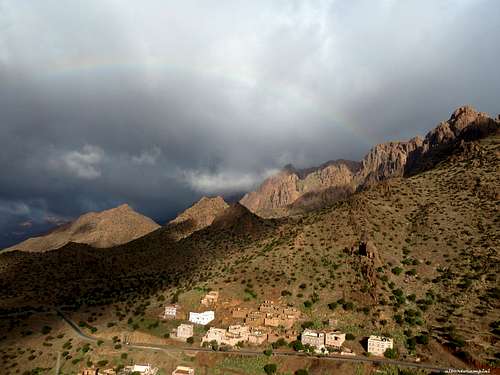
Ameln Valley
Several international flights run to Marrakech and Agadir. The best choice is hire a car (in the Airports there are many Car Hire Agencies).
- From Marrakech the road to Tafraoute involves a trip of 400 Kms and takes nowadays about 5 hours via the new Motor-way connecting Marrakech to Agadir, then following a busy road via Inezgane (near Agadir), Biougra and Ait Baha; alternatively you can follow the road via Asni, through the High Atlas range, a trip along a narrow mountain road inside a charming and scenic landscape, and Taroudant (it takes at least 7-8 hours).
- From Agadir the travel is shorter (you can drive to Tafraoute in 2 hours on a 170 kms good road), but the flights’choice is more restricted.
Jebel El Kest North Side and Taskra North
The development of the North side started slowly a few years after the exploration of the South side, but it have increased remarkably in the last period. Nowadays the North area counts numberless climbing routes, about 1000 at the moment, and it’s more frequented than the South one. It is better approached from the village of Ida Ougnidif rather than from Tafroute. In fact this area is quite far from Tafroute (located on the South side) and the approach from here involves a long car trip. There are five main sub-areas, from East to West:

A - Sidi M’Zal Area, situated close enough to Tizi N’Tarakatine Pass
Amongst the sectors of Jebel El Kest North Side, Sidi M'Zal is the nearest one to Tafraoute. Greek Buttress may be the main and most interesting cliff in this sector. This large dome provides some six/seven pitches strong lines on excellent orange quartzite. From the settlement of Sidi M’Zal a short dirty road leads into a lateral valley. From the parking lot, a pleasant one hour hiking is required to reach the base of the wall. The descent is quite long but easy and doesn’t involve climbing. A complete day adventurous outing.

|

|
Other interesting adjacent peaks are the Striped Walls (Crag NB), the Hidden Spur, the Twin Crags, these latter providing shorter climbs. In the area near the village of Aktil a long outing is provided by Great Aktil Ridge with the route Power to the Elves, an high crag on the left of the low Aktil Edge crag. Other interesting place to climb are the remote domes of Dotinzar Towers.
B – Ida Ougnidif Area, just very close to Ida Ougnidif and the Kasbah Tizourgane. From Tafraoute can be reached via Tizi N’Tarakatine Pass, road to Ait Baha.
From Ida Ougnidif a well surfaced road enter a valley southwest direction to Tanalt. Many cliffs can be viewed both side of the road. On left side (east) Adrar Iffran, Adrar Umlil (or The White Dome) and Adrar Asmit are some of the best choices departing from the small settlement of Tassila, reached by car turning onto a small dirty track just in front of a picturesque waterfall. From the village count 40 minutes by feet.

C - Afantinzar Valley, the beautiful high valley SW to the village of Idaougnidif
West to the Ida Ougnidif Area it begins the Afantizar Valley, ending on a high col, from where the road drops down steeply to Tagzene and Tanalt. This wide alpine valley proposes many cliffs, as Amelu Wall, the Sanctuary, Lower Eagle Crag, an imposing 300 mt wall on the left of the valley just in front of the little village of Anammer (20 mn walk). Anammer itself lies at the bottom of another dome shaped cliff, The Ksar Rock, full of interesting short but steep lines on superb rock (5 minutes walk).

|

|
D - Samazar Valley, a parallel valley N to Afantizar Valley, indeed a wonderful place, also known as "Shangri Là". It can be approached from Ighir, in the Afantinzar Valley, by an unsurfaced and carefully drivable track that leads into the parallel valley of Samazar, an adventurous tour in a primitive landscape. More easily, the valley can be approached from Tanalt driving along a road rising steeply (Samazar hairpins) to a col, from where it drops down, reaching the "heart" of the Samazar valley and joining the road coming from Ighir.

|

|

Along the track there are many interesting crags, such Flatiron, Dragon Buttress, Waterfall Walls, the mighty Great Rock of Samazar, Safinah Towers, Igiliz, Agouti and Rainbow Buttress, this one very close to Ighir.

|

|
E - Tagzene Area, up above Afantinzar Area, East to the town of Tanalt The most interesting cliffs in this smaller area are the Dwawj Slabs, next to the road; just West to the Afantizar high col, when the road begins dropping down direction Tanalt, the pleasant and easily accessible cliff of Babouche Buttress provides some interesting routes on excellent rock (lines 5-6 pitches long).

|

|
F - Taskra North
When driving from Kasbah Tizourgane to Ida Ougnidif, you'll meet a road starting on the right and entering a valley South/North oriented and located at the base of the escarpment lying on the North side of Jebel Taskra Massif. Many crags are close enough to the road and some are really impressive, such as the superb The Thumb, a 300 m. shaped dome with high quality big routes, just in front of the village of Assldrar.

|

|
Starting from Assldrar it's possible to climb some others fine routes on Antelope Buttress and The Turtle, both located on the left side of the rocky circus overlooking Assldrar.

Jebel el Kest South Side
It was the first area to be pioneered by a group of British climbers, during numberless trips starting from 1991, the year of the Gulf War, when a couple of climbers changed their original plan from Wadi Rum in Jordany toward Morocco. Overlooking the Ameln Valley and easily and quickly reached from Tafraoute, it offers many traditional and moderne climbs on perfect orange quartzite.

From the main W-E Ameln Valley, some different narrow short roads or tracks lead to the villages at the mouth of the various gorges, from which usually a shepherd’s trail can be followed to the bottom of the crags. Approach routes by feet take from 30 min to 1 hour and sometimes more. The most impressive wall on the Southern side is the Lion's Head. Here the main subgroups in the South side (from West to East): - Tagmout Area - Anergui Area - Igordan Area - Tamaloucht Area - Lion's Face Area - Oumsnat Area - Aguchtim Area - Tizgut Area - Tifghalt Area

|
|
Climbing doesn’t suffer official and established restrictions, but however climbers are urged to respect the crystal ethics of the British pioneers, in order to preserve in the area the adventurous traditional climbing. In all the routes to date, no bolts and a few pitons have been fixed or used. The quarzite provides ideal cracks to place friends and nuts.

Climbing history
It appears incredible that such a wide area, with so impressive mountains, could be completely inexplorated, as a climbing range, till 1991. More, it happened as a strange and casual event, due to a specific international situation.In the year 1991 voyagers and hikers safety conditions were not the best in the Middle East, due to the Gulf War. So, some British climbers, instead of going to the well known Wadi Rum area, casually decided to change their trip in favour of the Southern Morocco, remembering what their friends told them about great rocky mountains surrounding the oasis of Tafraoute. It was a revelation and the first routes were established by this British group. It was the first of a long series of annual climbing trips to the Tafraoute range.
The group was obviously a small one, but it increased step by step, and in 1996 also sir Chris Bonington joined the team, and a lot of new routes were opened. On 2004 a member of this exclusive group, Claude Davies, decided to share with the climbing community this treasure, editing the first guide, published by Cicerone Press. At that time 150 routes (from one to multi pitch) had been opened and recognized in the guide.
Climbing

Nowaday more than 1200 climbing routes are established to date in the region, from short one pitch to long big walls.Due to the “clean” ethics of Jebel el Kest climbing community, it is not easy to be sure you are climbing an established route rather than a new one. So, it is a good idea to study well in advance the three existing guide-books and the new Route-Books in either The Kasbah Tizourgane near Ida Ougnidif or Hotel Les Amandiers in Tafraoute (where you can report any new routes) or up-date on line at MOROCCO ROCK or CLIMB-TAFRAOUTE
Walking and scrambling
There are numberless options to walk in the area. The hiker can reach almost all the summits mainly by walking or scrambling, often following ancient shepherd’s paths. Other possibilities are short walks to the Ameln Valley ancient villages and to the scenic “Painted Rocks” (a few km. South from Tafraoute).
The most demanding and satisfactory ascents by walking are the Jebel el Kest main summit ascent and the Lion’s Head Normal route. See the main Jebel El Kest and Lion's Head pages on SP for the full report of the itineraries.

|

|
Flora and Fauna
The landscape is marked by the shape of the Argan trees, producing plenty of berries, which precious oil finds a large use in cooking and beauty culture, and by the palms in the oasis. We can find some other spiky vegetation as cactus, prickly pears and the beautiful but unpleasant Euphorbia everywhere along the approach tracks and on many climbing routes; the Euphorbia is growing mainly on the slopes and on the steep walls facing South and it must be avoided because of its irritant white milk.

|

|

|
The area counts many species of mammals, like gazelles, antelopes, wild boars, the native grey squirrels named "sib-sib" and many kind of birds. Various kind of poisonous snakes and scorpions have been reported, but it’s rare to meet them during late fall and winter months.
Geology and rock
The most common rock is a pre-Cambrian quartzite, which quality is often perfect; its plenty of cracks allows a pleasant and sure climbing, with many opportunities of good natural protections.Essential gear
Double ropes, a complete set of friends and nuts, quickdraws and slings, helmet and usual belay devices are all you need to climb in the area. Walking access (from a few minutes to a couple of hours) is often “on sight”, following shepherd’s trails. The descent is generally easy, scrambling down the opposite side, and rarely it involves rappelling or down-climbing: sometimes it’s obvious to an experienced climber, sometimes it is quite complicate and long.When to climb
The best seasons to climb are fall (from the end of october) and spring, till april, when the weather is mainly fine and the temperature is pleasant. Late in the spring and in summer the temperature rises up dramaticaly, and climbing is virtually impossibile. Winter (december to february) is traditionally the wet season and rain, cold and even snow, on the highest peaks, sometimes may be a problem. Nevertheless, you can find often pleasant temperature also in winter during the day, though the evening and the night can be quite chilly.Where to stay


- North-Side – A nice place to stay is the charming and traditional The Kasbah Tizourgane, nearby Ida Ougnidif
- South-Side – The best choice in Tafraoute is the Hotel Les Amandiers on a hill dominating the town. Other options in Tafraoute: Argana Guesthouse www.argana-tafraout.com, Hotel Salama, Auberge Les Amis and Hotel Tete du Lion. There is an equipped camping in Tafraoute.


"Tafraout - Rock Climbing in Morocco's Anti-Atlas" Vol I - The South Side of Jebel El Kest and the Ameln Valley by Steve Broadbent, Oxford Alpine Club 2013
"Tafraout - Rock Climbing in Morocco's Anti-Atlas" Vol II - The North Side of Jebel El Kest and Jebel Taskra by Steve Broadbent, Oxford Alpine Club 2013
“Morocco Rock – Jebel el Kest & Taskra North, 1000 Rock Climbs in the Anti-Atlas” by Emma Alsford and Paul Donnithorne, Crack Addicts 2012
“Moroccan Anti-Atlas North” by Steve Broadbent – Oxford Alpine Club 2010
“Climbing in the Moroccan Anti Atlas – Tafraoute and Jebel El Kest” by Claude Davies, Cicerone 2004