Confusion?
Kingtop is the highest peak in the Confusion Mountain Range in the western Utah desert. Most approach it via Bonney Stairs Canyon but on our attempt,
we used the Andy Martin approach via some backroads, roads that were a bit rough and required 4WD and high clearance. It comes in at #60 on
the Utah Prominence Peak list with 2350 feet of prominence.
I met my companions fellow SP members, Greg and Kadee, in Delta at the McD's there. We had about a 65 mile drive just to get to the turnoff that would lead us to the backdoor of the range via some details I had received from Andy Martin, who had done it just a week earlier. It was a drive that took us 13 miles from US 50/6 but that 13 miles took well over an hour of our time and the worst of it was the last four miles of an abandoned jeep road, dodging around a couple washouts and a road that had vegetation growing in the middle of the road. Carefully driven, those roads are doable. High clearance is a must however as well as 4WD which was needed as well.
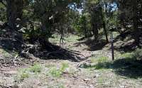
At the end of the road, the road turns into a trail and further passage is
blocked by the BLM signs prohibiting motor vehicles. About a quarter mile up the "trail", an old road bed reappears and makes for easy walking for awhile. While Kingtop is pretty impressive from US 50/6 as you are approaching the range, it is pretty tame looking from the "backdoor" approach. In his book on Utah Mountaineering, Mike Kelsey describes accessing Kingtop via Bonney Stairs Canyon, which has twice the gain and about twice the distance although it might be better to go that way versus the punishment we inflicted on our two vehicles as we forced them up the roads. We were not able to drive to the end of the road but had to stop short by almost a half mile thanks to the condition of the road that would've stopped our second vehicle had we tried it. The two vehicles the Arizona group (Andy's group) had made it to the end of the road but we just didn't want to push our luck at this one spot and hiked in from there.
![End of the jeep road]()
The hike to Kingtop the way we went was probably around 4 miles roundtrip with a thousand feet of elevation gain and it was pretty easy. Unfortunately for us, the desert was beginning to heat up and we found our selves thankful for taking plenty of water with us. The views of Notch Peak were particularly impressive, even at the distance it was from us. On the summit of Kingtop we found a cairn and a register, with very few names in the register. It had been five years from the first visitor to our friends from Arizona just the week before. We were the second party to visit in a week so it was interesting to see that situation. We noted on the map as well as a note from Andy Martin that there was another peak in the area that was listed as only two feet lower than Kingtop. We did not take the time to go over and investigate that spot as we were a bit behind our schedule for the day.
There is nothing technical about the hike and we found that at the most is was class 2 since some of the hike was cross country and we had to ascend up through some rocky/brushy areas. The views were nice in all directions with the view over to Notch and Swasey being the best of the lot. From the summit of Kingtop, we could see our next objective for the day, the Tunnel Springs range which were to the south west of us.
As I will most likely put up a page for this mountain in the near future, I'll plan on adding a lot more information about the area and its history and how to get there in more detail.
When we were leaving, one of the vehicles suffered a shredded tire. The backdoor approach did allow us to pick up a second peak later in the day. Had we gone in via the Bonney Stairs Canyon route, that would not have happened. As I mentioned earlier, if you have a high clearance 4WD vehicle, this route is very viable. I'd carry a second spare tire however. ; )


Comments
Post a Comment