
-
 8430 Hits
-
 72.87% Score
-
 3 Votes
|
|
Route |
|---|---|
|
|
Hike and some snow/ice walk |
|
|
A long day |
|
|
Long traverse and walk-up |
|
|
Introduction
The route here described is an extraordinary long traverse of part of the Sierra, from the guarded mountain hut of Poqueira to La Alcazaba, thought for those mountaineers already high in the mountains and with base at the mountain hut of Poqueira.Nevertheless, the normal, or most logical approach and ascend to this mayor peak, without passing by that hut, has its 'basis camp' at the alttitude plain of Cañada de Siete Lagunas (2.900 m), an idillic camping site.
To read the exact route description to this place, I adress you to From Trevélez via Siete Lagunas, route wrote by Joris, describing the ascend to Mulhacén from Trevélez over Cañada de Siete Lagunas.
The route described in my page will explain further the ascend to La Alcazaba from the Cañada de Siete Lagunas.
Approach
To reach the Poqueira Mountain Hut, at 2.485 m, there is a four hours walk from the mountain village of Capileira (1.432 m), or even shorter walk when parking the car (there is no public transport to this point) near the "Poqueira Electric Station" (1.570 m), a little bit further into the "Poqueira valley".When starting from Capileira there is a path which starts directly from the village (150 meters away from the Town House). Firstly it goes up to an unpaved road that goes down to the houses of 'La Cebadilla' (mostly unhabited) and to the Electric Station.
For those ones with car they could have reached this point from the village of Capileira. The road that goes up and out of the village should be followed for, about, 3 kilometers and then take the dusty road to the left (north).
Left behind the Electric Station, we walk into the gorge. There is a walking path (to the left) which starts to steeply climb in zigzag till it reaches a 'Cortijo' (traditional house). It goes further in traverse on the left slopes of a deep gorge. Finally, after reaching another 'cortijo', it descends again to the gorge. Here the bottom of the valley is wider and with threes. Crossed this valley the path goes up again in zigzag, leaves the last threes and, after a big stone-pile reaches the last traditional house ('Cortijo de las Tomas'), painted in white. From this point climbs again over a well marked path till the 'Refugio de Poqueira' (UTM coordinates/waypoint: E 0471307 - N 4098180 ~ Datum= Europeo 1950)
 |
Route Description
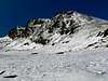
Walk from the 'Refugio de Poqueira' over the dusty road to the SE. After 15 minutes, before the road starts to descend again, go out of it to the left direction some far away stony landmarks placed on the slopes. My advice is not to bear to the SE but more to the NE. This may mean some cross-country stony work. After some walk (aprox. 40 minutes from the sandy road) a high altitude plain at 3.000 m is reached. There is even a short of unused off-road track up there. We will leave this track to the left and we will continue to the NNE following some stony marks here and there. At the end of this plain the path will descend following the shape of the slopes. It will level again and then it will go up once again. It will descend once more and again climb the last slope. We will always follow a short of Northern bearing. After this last ascend we will see the "Cañada de las Siete Lagunas" down the hill.From this point we have to descend to the 'Cañada', to cross the small river (leaving the big lake to the left). Once we are at the opposite side of the 'Cañada' we will begin to ascend the big stony shoulder in front of us (north). This can be done at different points with cross-country walk. This wide ridge, called 'Loma Culo de Perro' ascends to the NW direction a big peak called 'Peñon del Globo' (3.288 m). When going to La Alcazaba I do not advise to climb it but to leave it to the left. In traverse, and without trying to loose too much heigth we will reach a saddle.
Only from here we will be able to see La Alcazaba and its summit block to the NNW. The rest of the route becomes more obvious, since the peak is on sight: walk along the NE slopes of the Peñon del Globo without descending too much, trying to cross the upper side of this high valley to reach the south slope of the mountain. From that point, the summit is easily reached without route-finding problems.
Another option (recomended when there is too much/too deep snow for this last section is: reached the saddle from where Alcazaba is seen by first time (aprox. 3.100 m high) descend with a NE bearing and trying to reach the SE ridge of La Alcazaba. After half hour walking along this wide ridge (Loma de la Alcazaba) we will reach the summit. This ascending ridge walks along the cliffs of Tajos del Goterón, and it has perfect views over the next valley and the Puntal de Vacares.
 |  |  |  |  |
Essential Gear
In summer and in the hot period (from end may till end october) this whole route could be free of snow. Then it is a long rocky walk. Sometimes there are long cross-country walks. This will require good hard mountain shoes, plenty of water (our water supply can be refilled at the river of 'Cañada de las Siete Lagunas'), cap, sunglasses, suncream.In winter and colder months (from november till may) I advise to carry crampons and ice axe. These will not be always and overall needed in the mid-season months, but there could be some icy passes here and there. In winter this is a serious high mountain walk which will require extra warm clothing, snowshoes or cross-country skies. Rope and harness is not needed for this route.
The Poqueira Mountain Hut is open the whole year. They provide warm food, a good shelter and blankets. Nevertheless, I advise to bring your own warm sleeping bag.