-
 3853 Hits
-
 72.08% Score
-
 2 Votes
|
|
Route |
|---|---|
|
|
37.85785°N / 13.97221°E |
|
|
Hiking, Scrambling |
|
|
Spring, Summer, Fall, Winter |
|
|
Half a day |
|
|
Class 4 |
|
|
Tough Scramble |
|
|
Overview
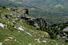
 The upper exit from La Padella The upper exit from La Padella |
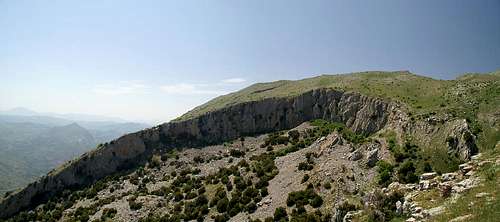
La Padella is a pan-shaped depression on the southern slopes of Monte dei Cervi. Depression might actually be the wrong word as La Padella is a circular zone, where the slope of the mountain collapsed and which today is cut through by a deep gully. The encompassing vertical walls are between 20 and 50m high and there are only three entry points into the collapsed zone - two from the gully from each side and one from the eastern rim of the circle.
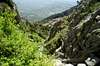
In contrast to Vallone Inferno, the other route that we did up the mountain - the route through La Padella is not as overgrown. However, following the gully out of the pan requires some class 4 (UIAA II) chimney-like climbing. The upper part of the route, especially near the summit turns into boulder hopping, easy enough on the way upwards but treachery on the way down due to the many plants and flowerd covering the limestone rock. On a wet day this part will get real slippery.
Getting There
The access to the trailhead is described on the Monte dei Cervi main page. The climb starts near a forestry station and follows a dirt road for the first kms.Route Description
 La Padella
- Start altitude: 1028m
- Summit altitude: 1796m
- Prevailing exposure: S
- Type: 1h on a dirt road, 2 1/2h along difficult trail-less terrain
- Protection: unprotected
From the trailhead at the forestry station follow the dirt road which passes the station to the east. After several ups and downs it reaches a gate, wher it splits in two. Follow the upper road which climbs slowly and which in the end comes by the entry to Vallone Inferno. Hike on for another 15 to thirty minutes until the road starts to switch back up the mountain.
Leave the road here in westerly direction and cross the slopes trail-lessly. If you keep the elevation you will meet with the lower gully coming out of La Padella, so the idea is to keep climbing a little to come up against the pan shaped depression near its lower end. There a clearly visible path descends the rocky wall into the circle and from there on to the upper gully exit.
This exit is the first crux of the route. It is very narrow but in general carries no water. If it dis, the water would come down in cascades, jumping several steps, which are up to 10m high. These steps have to be climbed, easy enough for most of them but in the central section you have several which require some experience. One time out of this narrow part the gully opens up onto a meadow and the valley turns left and westward.
At the wetsern end of the meadow you find the valley entrance, shortly after which you can see a farm house on the left hand (southern) shoulder . From here a path follows the wide ridge and soon turns into a kind of road, which eventually leads to a trough. Rather than following the road here, follow the ridge to the point where it meets the slopes of Monte dei Cervi.
Here the second crux follows - at first a feat of orientation. Head for a rocky patch, coming almost directly down from the summit, the only one which is clear from the dwarf trees which cover the rest of the slope. The patch is steep at more than 60° so that the trees don't hold here. However out of the cracks beneath the rocks a lot of plants grow, sometimes covering the rocks and making for precarious footing. The rocky section accompanies a small gully to both sides. Take the right (northern) one. It will lead you to canall-like shallow valley which leads directly to the southern summit of Monte dei Cervi. The actual summit is a bit higher on the plateau a couple of 100m to the north.
|