
-
 16292 Hits
-
 76.65% Score
-
 7 Votes
|
|
Route |
|---|---|
|
|
38.43830°N / 109.2286°W |
|
|
Basic Snow/Class 2 |
|
|
Half a day |
|
|
Class 2 |
|
|
Approach
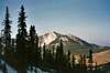
Follow the approach directions to the parking area at La Sal Pass at 10,125 ft. Or, park at the drainage just west of the turnoff to Beaver Lake at 9930 ft. The route to Mt. Peale is visible from either parking area.
 |
Route Description
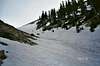
From either parking area, gain a visual of the mountain. More specifically, aim for the long, south-facing gully that you can see on Mt. Peale's west side. Hike north and east through forest and occasional open meadows. There is a 4wd road that climbs to just over 10,400 ft. You may climb this road, but leave the road as it makes a sharp turn to the left (west.) There are some game trails that can be followed through the grove of trees for a few hundred yards. Contour to the base of the couloir through these trees. It is helpful to maintain a compass reading and bearing to avoid unnecessary foot travel reaching the base of the couloir.
Once you reach the bottom of the couloir at 10,700 ft, it is likely to be filled with snow/ice until mid-summer. An ice axe and crampons are helpful/necessary for the ascent/descent. Climb the gully for 1,300 feet to the ridge crest and top out at 12,000 ft. The first several hundred feet of the couloir are the steepest angle at 30-35 degrees. The angle eases in the upper half of the couloir. There is an opportunity to leave the gully before the crest by angling eastward or heading up a spur gully. DON'T be tempted. This will only deposit you onto pancake-stacked, loose talus. Climb the main couloir to within a few yards of the ridge crest at the end of the couloir. At this point, leave the couloir and contour east and southeast along the ridge toward Mt. Peale. From the top of the couloir the remaining route and 700 ft are visible and obvious. The route is 5 miles roundtrip and 2,600-2,700 feet elevation gain.
 |  |  |  |  |
Essential Gear
Ice axe and crampons are recommended for the 1,300 foot coulair. In late summer the coulair will be free from snow and ice.
Miscellaneous Info
If you have information about this route that doesn't pertain to any of the other sections, please add it here.