
|
|
Mountain/Rock |
|---|---|
|
|
40.75780°N / 109.88384°W |
|
|
Uintah |
|
|
Hiking, Mountaineering, Scrambling, Skiing |
|
|
12011 ft / 3661 m |
|
|
Overview
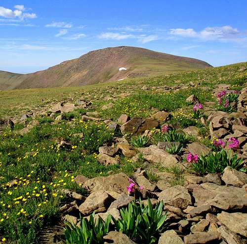
"Lakeshore Peak" is the unofficial name for a 12,000 foot peak in the eastern Uinta Mountains. It is named Lakeshore because it forms the east side of Lakeshore Basin, a beautiful basin dotted with alpine lakes. The peak is surrounded by many peaks of about the same elevation and as mentioned, is also surrounded by beautiful lakes and meadows.The east side of the peak is steep, but for the most part the peak is a gentle dome. The peak is seldom climbed even though it’s an easy ascent. Because the surrounding peaks are gentle and close together, you can climb many peaks on a single trip.
Most of the trails in this eastern section of the Uintas are not used much, and many are fading away because of very light or no foot traffic. Even though the peaks are easy to climb, and not very rugged, this is a good place to go come to if you enjoy solitude. Many trails are shown on the topo maps, but many of them don't exist anymore.
Like all peaks in the Uintas, except for Bald Mountain, Lakeshore Peak has no trail to the summit. It can be climbed on a day trip, but the area is surrounded by many nice backcountry campsites in the basins and around the fishing lakes.
The Uinta Mountains are one of the few mountain ranges in North America that run east to west rather than north to south. Within the Uinta Mountains are about 2000 lakes, and some 900-1000 are full of trout. Along with the San Juans in Colorado, the Uintas have more contiguous area above timberline than any other area in the Continental United States. This is a beautiful area with many lakes, meadows, wildflowers, and some rugged peaks. Solitude is usually easy to come by once you leave the popular fishing holes behind.
The Uinta Mountains are very rugged in the northeast section. Beginning at Hayden Peak and east to Mount Lovenia, the Uintas are not unlike the Tetons or other ranges. East of Lovenia, the peaks are more gentle, with a few rugged peaks (ie Red Castle and Henrys Fork Peak) scattered about until you are as far east as the Henrys Fork/Kings Peak area. East of Kings Peak, the Uintas become very gentle and the peaks are very rounded with only a few scattered cliffs about.
Utah's 12,000+ Foot Peaks With 200+ Feet Prominence
Utah's 12,000+ Foot Peaks With 300+ Feet Prominence
 "Lakeshore Peak" (12011') is the 85th highest peak of Utah by 300' prominence.
Getting There
Lakeshore Peak can be climbed from many directions. One is from the west and Paradise Park, one is from the east and from near Ashley Twin Lakes, one is from the Highline Trail near Hacking Lake and one is from Chepeta Lake. These are the accesses that will be discussed on this page. Other access routes are from the north and Browne Lake, but I haven’t access the surrounding peaks from there.The routes from the Highline Trail from Hacking Lake and the route from Ashley Twin Lakes are the shortest. The road to the Highline Trailhead is good for all vehicles, while Ashley Twin Lakes is accessed via a 4wd road. The other routes are attractive too, depending on which other peaks you wish to climb in the area.
Highline Trail/Hacking Lake Trailhead
From near the center of Vernal along Highway 40, turn north at the sign for Maeser and follow the road north to 500 North. Turn west here and follow 500 North to 3500 West. Turn north here. There is a sign for Red Cloud Loop Road. Follow the Red Cloud Loop Road through Dry Canyon. If you have time, make sure to stop at the pictographs and petroglyphs along the way.
The road becomes a good gravel road at the Forest Service boundary. Follow the Red Cloud Loop all the way to a major junction with the road to Hacking Lake. A sign points the way to Hacking Lake, and follow the road to near Hacking Lake. Instead of turning left at the lake, follow the main road right and to its end. This is the trailhead.
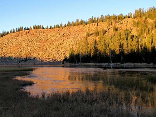 Hacking Lake.
Ashley Twin Lakes Trailhead
From near the center of Vernal along Highway 40, turn north at the sign for Maeser and follow the road north to 500 North. Turn west here and follow 500 North to 3500 West. Turn north here. There is a sign for Red Cloud Loop Road. Follow the Red Cloud Loop Road through Dry Canyon. If you have time, make sure to stop at the pictographs and petroglyphs along the way.
The road becomes a good gravel road at the Forest Service boundary. Follow the Red Cloud Loop all the way to a junction with the road to Ashley Twin Lakes. A sign points the way to Ashley Twin Lakes, but be aware of missing signs as they tend to disappear. Follow the road towards Ashley Twin Lakes. It quickly becomes a 4wd road.
Ignore the side tracks and stay on the main track until you reach the end of the rough road. Cars will have to be parked earlier.
Park here. This is the trailhead.
 Lakeshore Peak as seen from the ridge to Timberline Point. Ashley Twin Lakes is to the left and just out of sight.
Paradise Park Trailhead
Make sure to have a good map before driving to the trailhead. This is how we found the road in 1994, but things do change because this is an active logging area.
From Roosevelt on Highway 40, drive east along Highway 40 to 8500 East near Fort Duchene. Turn north on 8500 East. The road curves around to the east and becomes 9600 East and heads north to 7000 North. Turn right on 7000 North and drive east to the tiny town of Lapoint.
From Lapoint, drive north on FR (Forest Road) 104. Follow FR 104 to just short of the turn-off to Paradise Park Reservoir. Notice the road going past Mill Pond on the map. This is your road. Drive the 4wd road past Mill Pond and continue north. Continue along the rough road to a sign and 4-way junction. Park here.
If you don’t have a 4wd, you can park at Paradise Park Reservoir and hike to the 4-way junction, but the trail can be hard to find among the old logging roads. Make sure to have and use a good map.
Chepeta Lake Trailhead
Starting in Roosevelt,all distances are running mileposts, and are in reference to the intersection of US40 (200N) and State Route 121in Roosevelt, Utah; this is the point where US40 makes 90 degree turn at a traffic light.
M.P. 0.0 - head west on 121
M.P. 0.2 – turn right at “Y”
M.P. 9.4 - Stay Straight at intersection in Neola
M.P. 16.6 - Stay left, Road leads off to the right. (getting there “B”)
M.P. 17.8 - Stay right on paved road, dirt road goes Straight
M.P. 21.7 - Turn right onto FR 117 and cross stream
M.P. 21.9 - Turn right on to Elk Horn Loop road.
M.P. 25.4 - Stay Straight, Lower Pole Creek is on the right
M.P. 33.2 - Stay Straight, Pole Creek campground on the right
M.P. 33.9 - Turn left onto FR 110, Chepeta Lake
M.P. 37.4 - Turn right on hairpin, left goes to West Fork TH
M.P. 44.1 - Stay Straight, Chepeta TH on the left.
M.P. 45.6 - Trailhead at Chepeta Lake.
Routes Overview
As mentioned, Lakeshore Peak can be climbed from many directions. None of these trails and routes are used very much, so expect solitude as well as some route finding. Some of the many possibilities are mentioned below:Via Hacking Lake and Highline Trail
The route up Lakeshore Peak from the Highline Trailhead/Hacking Lake is but one (and perhaps the shortest and easiest) of the many routes that could be used to climb Lakeshore Peak. Because it is the route I used climbed the peak, it will be the route with a route page.
As peak climbs go, it’s a pretty gentle route and since the trailhead is at a relatively high elevation, it is a fairly mellow climb. The climb is above timberline for most of the way, so you have to keep a close eye on the weather.
See the route page for more details.
 Lakeshore Peak (12011') from the slopes of Mount Untermann.
 Red = My route to Mount Untermann and Lakeshore Peak. Purple = Alternate routes.
Ashley Twin Lakes and Lakeshore Basin
This route from the southeast is only a little longer and probably about as easy as the route from the Highline Trail/Hacking Lake. The road is much rougher than the road to the Highline Trail though.
The Lakeshore Basin is a beautiful area filled with lakes and meadows. The routes up Lakeshore Peak join the routes from the Highline Trail at the vicinity of Lake Wilde. You could also climb Lakeshore Peak more directly from Lakeshore Lake and the south ridge of the peak.
This route can also be completed in a long day trip.
 Approaching the gentle summit of Lakeshore Peak from the north.
Paradise Park
There are two major variations to the area from Paradise Park, which is a southern route.
One trail heads north from Paradise Park through Blanchett Park, Lightning Park, and Deadman Lake. From Deadman Lake, the Highline Trail heads east to Gabbro Pass which is on the standard route of Lakeshore Peak (see the route page for the Highline Trailhead).
A second trail heads northeast from Paradise Park and past Red Belly Lake and over the area of Lakeshore Peak. It is likely that the trail from Red Belly Lake to the peak is indistinct and I didn’t see any signs of the northern portion of the trail while climbing Lakeshore Peak.
Most people will want two days for these routes, or perhaps more if you are climbing several peaks in the area.
Chepeta Lake/Highline Trail
The Highline Trail also heads east from Chepeta Lake and goes over Gabbro Pass just to the north of Lakeshore Peak. This is longer than the eastern approach of the Highline Trail from Hacking Lake, but passes some beautiful lakes and gives you an opportunity to climb several more peaks along the way.
Plan on two days minimum, especially if you want to climb several peaks in the area.
Northern Routes
Maps show two trails approaching the area from Browne Lake. I have not approached these peaks from that direction, but am guessing that the trails are indistinct since I haven’t seen any sign of them where they join the trails and routes mentioned above that I have been on.
If you have a good map and several days at your disposal, this could make an interesting loop hike that climbs several peaks along the way.
Red Tape
No permits are required. Normal wilderness rules apply.Camping
Car CampingIf you like camping with not many restrictions, and without the crowds, this is a good place to come.
The road to the Highline Trail and Hacking Lake has many good campsites, including at the trailhead.
Dry Fork, on the road to the Ashley Twin Lakes Trailhead has many nice campsites in the forest, some with picnic tables and fire places. All are free of charge! There are other campsites closer to the trailhead along the road, including near the trailhead.
The road to the Paradise Park trailhead has many nice campsites as well. Paradise Park is the only official campground in the area.
The roads to Chepeta Lake have many good campsites as well.
Backcountry Campsites
There are many backcountry campsites along all routes.
The route from Hacking Lake and the Highline Trail is above timberline for most of the route though, so it’s best to drop down into the Lakeshore Basin to camp.
The route from Ashley Twin Lake has many good campsites in the Lakeshore Basin.
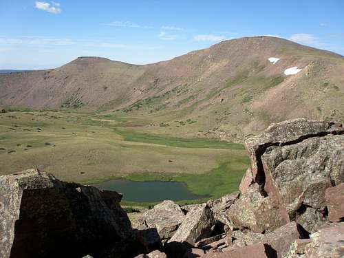
 Looking down to the Lakeshore Basin (right) from Lakeshore Peak. Many good campsites are in the basin.
The Paradise Park Route has many good campsites with water including Corral Park, Macks Park, and Fish Lake. Good campsites are around Hooper Lakes near the Ashley Twin Lakes Trailhead.
The route from Chepeta Lake has good campsites around Deadman Lake, and although not crowded is the most popular backcountry destination around here. It would make a fine base for climbing many peaks in this area.
When to Climb
Mid-July through Mid-September is the normal hiking season. The roads in the area are usually open in late June or early July. They usually close when ever the first big snowstorm of the season hits, usually between mid-September and mid-October.While it is true that Lakeshore Peak is a stiff one day climb in summer, by Uinta standards, it is still a short climb. This is not true in winter. None of the roads in the area are open in winter. I don't know if the mountain has ever been climbed in winter.
 Lakeshore Peak in late July during an extreme drought year. Usually there would be more snow around.
Mountain Conditions
Contact the ranger station in Kamas for current road and trail conditions. Their phone number is 801-783-4338.Click Here for Weather Forecast for Lakeshore Peak
Here are some average highs and lows from the 12,139 foot elevation (3700 meters) in the Uintas (about the same altitude as the summit):
| MONTH | HIGH | LOW |
| JAN | 14 | -1 |
| FEB | 16 | 1 |
| MAR | 19 | 4 |
| APR | 27 | 11 |
| MAY | 35 | 18 |
| JUN | 45 | 25 |
| JUL | 55 | 32 |
| AUG | 53 | 31 |
| SEP | 45 | 24 |
| OCT | 34 | 15 |
| NOV | 22 | 8 |
| DEC | 17 | 3 |