
-
 3022 Hits
-
 72.08% Score
-
 2 Votes
|
|
Route |
|---|---|
|
|
46.87670°N / 12.34460°E |
|
|
A long day |
|
|
Walk up, easy scrambling |
|
|
Overview
Referring to the guidelines of this fact sheet
• General data
- Start altitude: 1389 m
- Summit altitude: 3056 m
- Type: marked hiking trails, some talus and easy scrambling,
- Protection: most exposed sections fixed with iron cables
• Effort: 2000 m ascent, 2000m descent
• Power: 2
• Psyche: 2
• Orientation: 2 - easy in good weather and with no snow
• total time: 5 h ascent,; 4 h descent
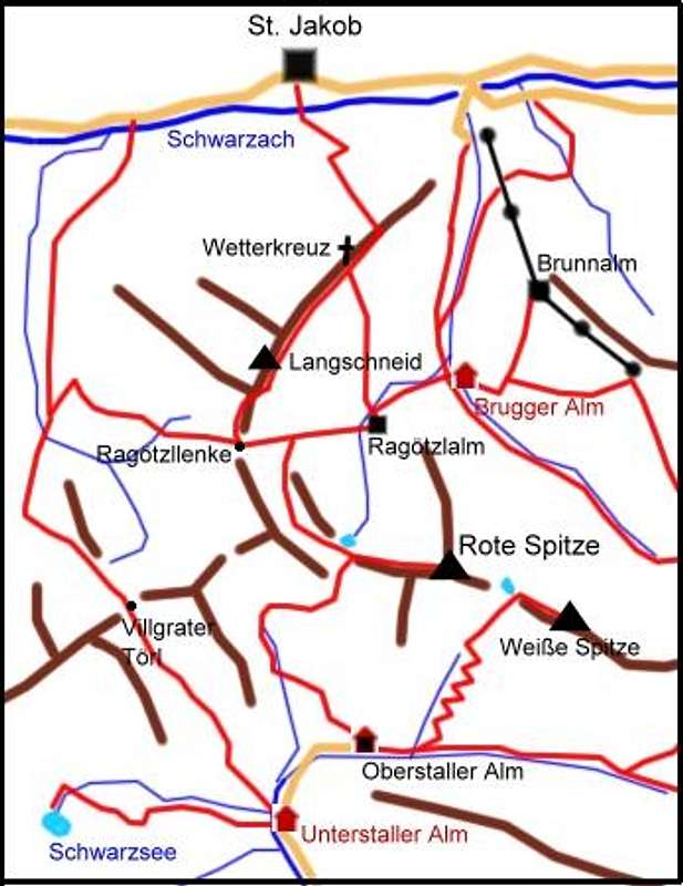
The highest starting point would be the top of the cablecar to Brunnalm (2053 m), starting with a descent to Brugger Alm (1818 m).
But if you are fit enough and want to enjoy a day in the mountains without technical support I recommend starting at the village of St. Jakob in Defereggen (1389 m).
Route Description


Just cross the Schwarzach river and take the steep path that leads you through the zone of larch forest to the nice viewpoint of the Wetterkreuz (2233 m), that is a landmark on the NE ridge of Langschneid.

There you leave this ridge and cross the eastern slopes of the Langschneid, loosing 100m elevation to Ragoetzlalm pasture (2115 m).You turn right, heading for Ragoetzllenke pass, but at a elevation of app. 2300 m you turn left and enter a little high valley that leads to a little lake

(nice view to Grossglockner) and to the notch above where a marked route from the south side discharges.

From there you follow the red markings to the fore-summit, traverse some towers on the left side and follow the ridge with some ups and downs to a final notch from there some cables help over the most exposed sections to the summit.
Descent
Descend on the same route until you reach the meadows above Ragoetzlalm pasture. You may go down there directly to the Defereggen valley. But if weather is still fine and you still have some power left I advise to turn left, trying not to loose to much elevation to traverse to the path that brings you to Ragoetzlenke pass (2500 m). From there it is very easy to gain the summit of the Langschneid (2689 m). This outpost is the best lookout down to the Defereggen valley and back to Rote Spitze.

The descent along the NE ridge is steep but not difficult. At Wetterkreuz you meet the route you already know from the ascent this morning.