Preface
In late July 2012, I decided to resign my job and move out of my residence. I did so to fulfill a dream of mine by traveling the United States and living out of my tent. I was not driven to summit as many peaks as I could, or visit as many individual states as I could. It was all to be a spontaneous, wandering journey taken day by day without rigid plans or agendas. Simply stated, when there was a mountain, canyon, desert, forest, beach, or other wilderness area nearby that beckoned to me, I would go there.
My wilderness travels lasted for the better part of three months, until cold winter days and nights eventually chased me indoors. Of the countless wonders I saw along the way, I tried to capture some of the better ones on camera. Of the many thoughts and activities I embraced, I tried to record most of them in my daily journal. I briefly considered posting my full journal here, but even for those who know me and possibly want to read its unedited entirety, I am not keen on taking that much of someone's time. So instead, what follows is a condensed, but still lengthy, collection of excerpts and pictures, as I try to highlight some of the more enjoyable and interesting moments of my wandering journey.
Upper Peninsula, Michigan
This day I woke up on a soft and thick mat of pine needles within a quaint pine grove. I think a large animal of some kind wandered into my general area during the night, or maybe I was mistaking the light rain, but in either case I made it to the morning without a problem. I left pretty early and got drenched from the rain-soaked overgrowth as I hiked the rest of the way to my car. From the southern Hiawatha National Forest, I drove north across the peninsula to Tahquamenon Falls. My understanding was that only the Upper Falls were really marvelous, so I only went to that section of the park. Even with seasonally low water volume here in late summer, these falls are wonderful. The great width of the waterway is what sets them apart. There was not a great vantage point for a photo but the trail does take you right beside the powerful falls.
---
...After leaving around lunch time, I traveled a very remote road through Luce County, westward paralleling Lake Superior’s shore. The winding county road here is very bumpy, rutted gravel with random pockets of soft sand. It was bone-jarring and miserable until I came upon the solution: rally-style driving. My sustainable velocity around 45 mph was well over the posted limits, but amazingly it was much smoother than driving half that speed. Now I was floating over many of the ruts and channels. It was a blast, and additionally I was approaching my destination that much more quickly. Soon I was at the town of Grand Marais, the east edge of Pictured Rocks National Lakeshore. I reserved a backcountry campsite within the lakeshore at a small fee. The park encompasses about fifty miles of Lake Superior shoreline, and I had to drive through the forest along half of it to reach my trail. From the parking area, it was a 4.6 mile hike, mostly along sand ridges and bluffs standing above this remote section of shoreline. Despite the sandy ground, however, the land is still blanketed with predominantly evergreen forest like the rest of the Upper Peninsula. The northern forest here stretches forever. It is a cathedral of evergreens randomly interspersed with smaller deciduous trees. My campsite is very isolated; the beach looks like it is just mine for miles. It is clean white sand strewn with rounded rocks and driftwood, and the lake is continually pounding it with ferocious waves in quick succession. Lake Superior has an edge to its demeanor when all other great lakes are calm. These waves are constant and loud. Tonight, they will sing me to sleep here on this ridge above them.
![Pictured Rocks]()
---
...From Miners Falls, I continued a couple of miles north to the shoreline and Miners Castle, a unique sandstone formation on the shore bluffs of the western lakeshore. The North Country Trail intersects here, so I packed some supplies and set out for a nice day hike going east. Where the Niagara Escarpment line moves slightly inland, the shore once again becomes a sandy beach, and the trail descends to it before climbing back on the bluffs to the east. I continued on the steadily forested trail high above the water, to dramatic views of the cliffs where the forest allows them, and eventually to a wonderful area at the Mosquito River 4.9 miles from the castle. This was a really special place for relaxation, snacking, and even swimming. The sandstone here drops into the lake as a series of tables. Some levels are just above the water, right at the water, or just below the water to create an enjoyable natural wading pool. These tables extend out a short distance to sudden drops into deep sapphire blue water. I found a small and private secluded cove next to the east edge of the lakefront cliffs and had a short swim. The water was very cold initially, becoming just slightly more tolerable with full immersion. My swim in total was just a few shivering minutes, but it did nothing to diminish the beautiful area. This is the place I would most want to revisit at Pictured Rocks. I left refreshed and cleaned for the 4.9 mile return hike.
![Miners Castle]()
Badlands, North Dakota
Though I had done nothing physically exerting since my shower yesterday, I took my second shower of my stay after awaking bright and early. I guess while one is available here at Turtle River State Park, it is an indulgence I cannot ignore. At 6:40 AM I was fully packed and ready to take off west for the badlands, and my car did not start. The battery hardly cranked anything. Though it gave no hints of foreshadowing in the previous days, I concluded that this very old battery was just at the end of its useful life rather than the victim of some overnight power drain. Rapidly, my day began to disappear directly because of this automobile failure. I walked once through the park to the visitor center to find out it opened at 9:00 AM. I returned to my car, waited until then, and walked back to the office seeking assistance. The girl on duty was very sweet and helpful; she lent me a battery jump pack without hesitation. I returned again and used the jump pack, but the car did not start again. I walked back to the office a third time, where I waited for a ranger with a truck to become available to jump-start my car. Happily, a ranger did just that and I was on the road at 10:40. At Devils Lake, the next town, I stopped to find directions to an auto parts center, and the car did not start again. Amazingly, the battery’s sudden death even resisted the alternator’s charge during the drive. After pushing my disabled car across the lot, out of the way, I made the walk to the nearest battery supplier and lugged my new unit back to the car. After doing the installation myself in that lot, the car worked beautifully and I exited town around two hours after arriving. Ahead of me was a chaotic scene, the western North Dakota oil boom. On every road, there is a multitude of industrial equipment and delivery trucks. In every town, there is an overflowing population of pick-up trucks with out-of-state license plates. The bustling activity here is something to behold in such an otherwise empty landscape. The extravagant delays, both from the traffic jams and my earlier auto repair, meant I could not reach the north unit of Theodore Roosevelt National Park until sunset, when the dramatic badlands jumped instantly from the ordinary plains.
![Achenbach Trail]()
---
...An impressive lightning show entertained me for part of last night, but that thunderstorm must have had other grounds to visit, for I only encountered a quiet overcast sky and steady misting rain in the morning. The mist enshrouded the badland ridges until about 9:00 am, at which point I hopped aboard my bicycle and crossed time zones into Theodore Roosevelt National Park North Unit. I leisurely rode the hilly scenic drive as far as I could, to a roadblock six miles west of the park entrance. The scenic drive does go an additional eight miles when it is fully open, but a long hiking trail also connects to the endpoint oxbow overlook. So I ascended the large badland ridge south of me from the Upper Caprock Coulee trailhead. Interestingly, all the ridges here are covered with juniper forest on the north-facing sides, but they are mostly barren on the drier and sunnier south-facing sides. So I was mostly enshrouded in forest until I reached the ridgetop where, nearly a thousand feet above the Little Missouri River to the south, the badlands treated me to a wonderful panorama. The river valley was a sea of woodlands underneath colorful layered ridges stretching to the horizon. The badlands were like controlled chaos, bluffs and hills of every size and angle. Sediment bands of grays, browns, yellows and even some reds connected them all, but not without some occasional breaks in the chain from past landslides. These slumps would exhibit the same sediment patterns, just at ground level on the different plane. I followed the Coulee Trail to the North Achenbach Trail, which descended past chunks of petrified wood beside the Little Missouri River, but I had to do so slowly. The morning mist was now replaced by an unyielding sun, and here on the south-facing slopes of the river valley, I had very few respites of shade. Before I could reach the named oxbow overlook, I finished half of my water, so I took no chances and turned back after a curious visit off-trail to the river bank. Up close I got to see the incredible silt content of the thoroughly brown river, whose tiny feeder channels oozed dark brown water past the intricate rivulet erosion dirt formations. When I returned to the trailhead, my hike totaled about six miles, a tougher than usual six miles over steep sun-baked ridges. I refreshed with some snacks and water at the park’s Juniper Campground picnic area, and then I toiled over a couple of steep cycling hills out of the park, over the river and back to my lonely National Grassland campsite after totaling sixteen miles on the bike. I relaxed in the shade of the campsite and refueled for the last three hours of sunlight. While writing in my journal, I was treated to a fun chat with a Sturgis-bound biker who dropped in to the campground. He kept calling me “tough guy,” but not in a condescending way. I think it was just how he refers to people in the second person. Maybe my hair gave me some street credentials. He was talkative and surprisingly open about his personal finances and experiences, neither of which I had asked about. I cannot say I was ever fully confident about what was going to happen next, but I enjoyed the lengthy meeting. We went on our separate ways; he continued on to Sturgis and I lied down for the night.
![Upper Caprock Coulee]()
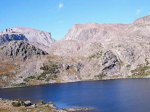
Black Hills, South Dakota
...The return hike was relatively routine until I reached the initial section that I bypassed yesterday in favor of Wind Cave’s Lookout Point trail. This was the most beautiful area of the entire park to me, a deep valley surrounded by colorful orange and cream cliffs and occasional steep grass-covered slopes. Within it, Beaver Creek flowed tranquilly beside the cliffs to a marvelous gap into which it disappeared and became an underground stream. Another surprise awaited me when I rounded a corner of the tall bluff walls and encountered a bison herd, full of protected young calves, in the trail close in front of me. Quickly, I ascended a conveniently located steep slope to the north side where it joined a section of sheer cliff. From the cliff edge a few hundred feet above the valley floor, I observed the herd grazing westward. It was a real treat to watch, just one of many I have received in the Black Hills, but I was about to get an even closer view. After bypassing the bison herd on the ridge top for a 10.8 mile hike, I set up my backcountry tent site on that same ridge top and prepared for a quiet evening. However, a short time later, the grunting of bison began to manifest itself and it quickly grew louder. Somehow, they must have accessed a gentler slope to the ridge, because the herd suddenly appeared. Slowly and steadily, they came directly to me. At a gap of about fifteen paces, I calmly but expeditiously fled my tent, and while trying to project a confident demeanor to the gigantic bison staring right at me, I climbed a tree previously selected beside my tent. While I did not expect this, I considered the possibility beforehand, and here, chance favored the prepared mind. The spectacle overwhelmed anything I saw before on the bluff edges. This herd of roughly fifty bison lazily shuffled along its course, right around my tent, directly beneath me, close enough to touch had I so dared. Not one of them displayed the smallest hint of aggression or alarm, which surprised me given all the young babies moving around. The herd meandered through and took occupancy of the large meadow surrounding me on parts of three sides. They continued to graze and grunt in the area around me as the sun set. They seemed to have no cares about sharing the area, so maybe I should not either.
![Black Hills]()
---
...After eating brunch, I loaded my backpack and headed southeast into the Rushmore rock climbing area. The short trail winded its way between various light gray pillars and sheer faces, but I do not have the gear or capability for this advanced vertical climbing, so I just continued southeast through the extremely rugged terrain. I came across a shorter rock fin that I topped. It was sheer on one side but more accessible on another, just requiring a risky climb of ten feet or so, and it made a good spot for lunch. However, this did not satisfy my appetite for good climbing, so I headed toward a sharply inclined block standing out further to the southeast. I ascended to its exposed rock base and began a steady climb up a relatively consistent 40-50 degree pitch blessed with great grip. In places where the angle increased, I was able to find long cracks and crevices to lever myself and maintain stability. Nearing the summit, where fewer options were available, I had to hug some exposed ledges, abandon my backpack to squeeze through a very narrow gap, and then right at the summit block, I was presented with a tough choice. With vertical or nearly-vertical cliffs on two sides, and a slick face above another large drop on a third side, my best option was a smooth, sharp-angled face without many places to grip. While I really wanted to reach the summit, the holds on this face did not look too adequate, and slipping off would be fatal or close to it. After studying the few available notches, I had to hook my hands on the awkward angling north edge and keep my entire body pressed on the rock for friction, but I got to the absolute top and climbed off safely. This was a tough climb at the limit of my current ability. I soaked it up for over an hour after retrieving my backpack just below the summit, eating a snack, nursing cuts from the unforgiving quartz crystals in the rock, and gazing at the surroundings. The summit view was a pine forest sprouting with gray-white rock pinnacles and faces, including the plain backside of Mount Rushmore. After I fully climbed down, I planned to bushwhack back to camp on a general northwest heading. I did this for maybe an hour until I happened to exit the forest a mile west at Horsethief Lake. My aimless trek through the forest paid off here as I enjoyed an invigorating swim in the lake. It could not have worked out any better. Though the water was colder than Lake Superior, I stayed in long enough to emerge refreshed and cleaned, and I walked the road back to camp.
![Rushmore Area Pinnacles]()
---
...In the highest reaches of the Black Hills, many lifeless trunks are scattered about, broken off maybe 10-15 feet high, with their former branches strewn about the ground below. Of most intrigue, I could hear one that was about to snap, and I eventually identified it to get a closer look. Pieces of its bark and heartwood where splintered off, and as the breezes blew its canopy around, the trunk was loudly straining out ominous sounds of its imminent downfall. I could not wait forever to actually see the tree fully snap, so I progressed south to Harney Peak, already in clear view. Harney Peak’s summit, at 7242 elevation, is the highest point in South Dakota. So the traffic here on the trail is pretty voluminous concerning hikers and apparently also concerning horses. Though I did not actually see a horse on trail, the paths of dirt and sparkling minerals are peppered with horse manure for miles within the peak. I did climb to the crowded summit of Harney Peak, which is covered by a fire tower that yields infinite views. I could clearly see all the way to the plains surrounding the southern edges of the Black Hills. After that great effort to get there, I certainly took my time eating dinner and gazing into the distances. But once sunset neared, I dropped back on trail to select a free dispersed campsite in the forest south of the mountain, almost inside the Custer State Park northern boundary. In fact, it may have been inside the boundary. That would be against the park rules, but I have no issues with being a rebel visitor of South Dakota. I do know for certain that my chosen campsite was on a slope, because there were no flat places that high in elevation and I just did not want to search any longer.
---
...I finished the last 11.1 miles of my Black Elk Wilderness loop and met my car still at the Wrinkled Rock camping area. There I was greeted with an enthusiastic, mildly awkward hug from a California hiker who recognized me from Harney Peak yesterday. She chatted with me as a long-lost friend, and then just as suddenly, she left. I was slightly bewildered at the whole situation, though I am sure she meant only the best. Next, I reloaded on food and water, then I set up my tent for one more free night at this convenient camping site. For the remainder of the evening, I just relaxed aside from a reorganization of the apparel space in my car, and I rode out the cold-blowing wind.
Big Horn Range, Wyoming
...Anyway, I headed into the east half of Cloud Peak Wilderness for a proper backcountry hike. It turns out that what I thought were meadows are more like wetlands. Once I went past my campsite, I started to see quite a few of them dotting the forest. Some are proper lakes while others are filled with tall grasses in shallow water. Then, as I followed Forest Trail 95 south to start my day’s loop, the adjacent Sherd Lake surprised me with a moose. I slowed down but the trail continued to bring me closer to the moose until it noticed me. As far as I understand, mooses are very territorial and consequently dangerous, and this one was watching me as it munched on the shallow water vegetation. Very conveniently for me, the trail turned inland away from the lake just as I was going to make an off-trail detour.
---
...The view opened up to another lake, presumably Otter Lake. Yet again, I had another moose encounter, my third of the day. This moose was standing in the lake shallows, and it made me more uneasy than the first two because it was simply fixated upon me. I abandoned the trail to try and go around the lake behind some cover and hopefully meet the trail later. But every time I glanced, the moose was upright, ears straight up, staring directly at me with too much interest. I came to a large ditch in an open area, and in my haste to cross it, I snapped one of my walking sticks. This was kind of a bummer, honestly, since I had used it for almost a year since picking it out of Washington. I scurried into the forest hoping the moose was not following behind. The moose stayed in the lake, and my attention turned to finding the trail. Thankfully, I soon saw the trail again and I picked it up with my one remaining walking stick. As I continued north and west, I eventually found a pine stick that was somewhat straight enough to be a new walking stick, and I reached the tree line area. Here I ate and rested for a while in the dominating scene of the Big Horns. My return hike was a direct line east instead of the southern loop, so I reached my same general campsite area by mid-evening in light sprinkles, completing a fourteen mile loop hike. The only stop I made was to watch the extremely soft rain pepper the glass surface of one lake, just enough to blur the reflections of the shoreline trees and mountains behind. This was very serene and beautiful, and this time, there was no intimidating moose to spoil it.
---
...The northward route of the Mistymoon Trail is a great avenue for reaching the Big Horn Range’s highest interior peaks. I completed the free camping registration and started the trail just before noon at a very deliberate pace. My backpack was filled to capacity with three days of food and water among my other gear, probably weighing more than I had ever hiked with before. I also combined my steady lack of speed with many rest breaks in the hope of preserving my back. The strategy worked as I painlessly worked my way past West Tensleep Lake and into the wilderness. I walked along a mountain stream and gradually ascended to sights of ridges and mountain faces. Along one overlooking ridge in particular, I had another casual moose sighting, this time with plenty of distance in-between. The vistas really turned special when I reached Lake Helen, the first of a chain of lakes below Mistymoon Lake. It had such clear water at the shores turning deep blue in the depths, surrounded by a debris field of gray-white rocks interspersed with clumps of short alpine grasses. A few evergreen trees worked their way into the picture variously around the lakes. Finally, all of it was dominated by the tall barren peaks and ridges of the central Big Horn Range, just holding on to their last few patches of winter snow. This was the theatre for me as I walked the last mile or two of the Mistymoon Trail to its namesake lake. Alpine lakes just provide some of the finest landscapes in nature. I cannot get enough of them.
---
...I did not mind waking up in the middle of the night this time. Mistymoon Lake rests above 10000’ elevation, many miles from any artificial lighting, in an open area outside of the forest. This means terrifically dark and unobstructed skies. Therefore, when I looked outside at some wee hour, I saw infinite stars as if they were set on enhanced brightness, and a clear Milky Way streaking across the entire sky. Though I was quite cold and tired, I spent a while mesmerized by the heavens without any urgency to get back to sleep. I would need all the rest and energy I could get, however, for the task ahead of me today. Following the Cloud Peak route described by the ranger yesterday, I walked around the mountain ridge northwest of Mistymoon Lake and descended into an alluvial valley behind it. Here beside an alpine stream decorated in purple and yellow flowers, I began the steady ascent east.
---
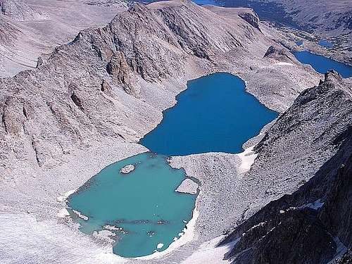
...The ridge here was flanked by vertical walls on both sides that stood only a few steps apart. It is always quite a rush walking next to such a precipitous drop and I really enjoyed it here. At this level of altitude, I kept finding time to stop and watch those views, because I could only ascend in short bursts. I was constantly out of breath. My heart was thumping with force and I could feel my head throbbing in the same rhythm. The altitude and the cumulative effect of this lengthy climb were joining together against me but I was very close to the summit. Climbing over and around much larger boulders here, some as big as automobiles, I made the last push and reached the summit table at last. The ultimate summit was a low rise on the summit table readily marked with several rock cairns. I walked to it and officially completed the climb of Cloud Peak, the roof of the range at 13175’ elevation. It is the highest mountain I have climbed to this point and with it comes the highest sense of satisfaction and achievement. Here I finally dug into my lunch while staring almost literally across the state of Wyoming. To the west, I could faintly note the silhouettes of the Rockies through the haze, and the high plains stretched in vast distances to the east. Most amazing was the Big Horn Range itself, with the high peaks standing north and south of me besides several gorgeous alpine lakes. Just below the giant east face were two lakes of strikingly different colors that shared a narrow stretch of shoreline. The aptly-named body of water, Glacier Lake, was a bright sea green color on the upper half, probably because of glacially-created rock dust, and it appeared to feed the lower blue half of the same size. The surface of the green section held several motionless chunks of ice from the snowpack surrounding it. Both surfaces were perfectly still. I have seen many wonderful scenes but this may be the most amazing of them.
Teton Range, Wyoming
...I stopped by the Jenny Lake area to walk the 0.6 mile lakeshore loop trail and take my first extended view of the jagged Teton Range. The viewpoint was striking. This range’s skyline is so wild and picturesque. I wanted to get a closer look on the trails, so I returned to the parking lot to pack for my backcountry hike. While I was packing inside my car, a neighboring tourist opened his door into my car, so I took a small moment to thank him for his efforts. He awkwardly shuffled around for a moment before resuming his packing activities. Soon after that, I was ready myself and I hopped over to the Lupine Meadows Trailhead to begin my ascent into the Tetons.
---
...Surprise Lake is nearly a perfect circle of clear blue water, maybe sixty yards in diameter, sitting beneath the enormous presence of the highest Tetons. It was just another beautiful example of a high mountain lake in summer. While enjoying my meal and my view, I thought I heard a small commotion, but nothing caught my eyes. Then a minute later, from the forest on the opposite side of the lake, three black bear cubs walked into the shallow edge of the lake and began to quietly frolic in the water. What a sight, my first bear encounter in the wilderness. The cubs were very small, certainly newborns of this summer. I was engrossed in the show they were unwittingly producing, but obviously a great part of my attention was divided toward the current whereabouts of the mother bear. In this case, I was prepared for a thorough retreat, but the cubs eventually moved on and the mother never materialized. I expected to see her eventually but all I noticed after that was occasional rustling sounds in the opposing forest. Still, the expected presence of a protective bear interfered with my wishes of continuing to the mighty rock faces just ahead for some amateur climbing. The bears’ area of activity was directly in-between, I could not take the chance.
![Surprise Lake]()
---
...I settled on another opportunity and started scrambling the steep ridge lying on Surprise Lake’s south shore. It was a slow ascent but very rewarding. There were no vertical faces but several areas requiring hand holds to ensure stability, which is the balance of difficulty I enjoy most. I climbed to the exposed summit of the rock fin just south of the lake and a few hundred feet above it. The view presented almost the entirety of Grand Teton National Park. Grand Teton itself is awe-inspiring as it stands tall above all the other towering peaks. The scale of its size is exceptionally massive even from this vantage, 3000 feet above Jackson Hole. Hazy horizons once again limited the distance of my views, but I did receive a great aerial view of the area’s lower lakes and tracts of forests, which looked as small as puddles and clumps of uncut crabgrass. While I finished dinner on the ridge, I caught a noteworthy perspective of an airplane flying south through the valley. The plane, as well as a second one a short while later, was flying under me. High above the valley and low below me, what a peculiar sight it was. I climbed down my mountain while the shadows climbed up the adjacent mountains and I returned to my campsite.
---
...I had a number of observations regarding my body when I awakened this morning. First, my muscles were not really sore, which was a mild surprise. I also found myself to be very dirty and this was not surprising at all. But what was most amazing to me was my pulse rate. This morning, I counted forty-eight pulses in a minute. I counted twice more to verify a startlingly low number and registered forty-eight and forty-nine so the rate was legit. I do not know if that is good or bad but it did not inhibit me from making the short walk to my car, where I promptly set about cleaning myself as best I could. My dirtiness really reached epic levels; I will keep a better eye on that going forward.
---
...The Snake River was great for a brief and effective cooldown in the midday sun. I remained here for about the entire afternoon and came away with the beginnings of a nice tan. Late in the afternoon, someone’s dog wandered over to my area, and it decided to walk directly beside me and shake itself dry. After that unwelcome shower, I pretty much decided it was time to move on. For reasons like this, I have always liked kitty cats better.
---
...I put together my bicycle and accomplished both by taking the long route south to the wonderful Thomas Discovery Center for a permit. The Jenny Lake center was five miles closer, but I wanted a nice ride of about fifteen round-trip miles. The winds were wildly gusty and mostly against me on the way there. At the center, the exhibits were very impressive and I was sidetracked for a while before I secured a free backcountry camping permit for Open Canyon. On my returning ride with the tailwind, I came across one of those radar display boards on the adjacent Teton Park Road. This time, the advertised speed limit was 30, and with this tailwind, I thought I had a chance to break it. There was an opportune break in the traffic going both directions, and I seized my chance. I got off my bicycle and ran it through the ditch and onto the road. My speed climbed and climbed, and then it leveled at 27 miles per hour. I was short by four. But the Teton views from here were tremendous.
![Teton Range]()
Wind River Range, Wyoming
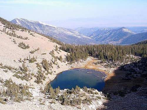
...A little after 6:00 in the evening, I finished packing and loaded up on a big meal of food and water. Then I started out east on the Pole Creek Trail with provisions for an uncustomary trip of three nights and two days. I just hiked up the trail for slightly over an hour, but that was long enough to meet four trains of pack horses and mules coming down the trail, led by solitary ranchers. Most of the trunks in this pine forest have no climbable lower branches. My plan to store my food on a branch seemed suddenly difficult until I ran into a fair climbing tree, just as I began browsing for camp two miles from the trailhead. Climbing and hanging my backpack manually was my only option without a rope in hand. It was fun except that I ended up with more pine needles inside my clothes than I could count. I may spend half the night digging them out. I set up camp away from my backpack and I lied down to rest in almost total silence. It is somewhat eerie here as the only sounds are from trees occasionally cracking and snapping. There is no wind now but some of the trees have been blown against others, and apparently the stress causes the noises I heard all throughout the trail. The waxing gibbous moon is shining through a gap in the canopy, brightly serving as a spooky nightlight as I go to sleep.
![Island Lake]()
---
...Walking into the Titcomb Basin was amazing. This place immediately presented itself as one of the most magnificent places I have ever seen, and there have been a lot. The basin is a chain of beautiful glacially-fed lakes connected by a stream coming down from the theater-like wall of peaks at the continental divide of the Wind River Range. The basin is covered largely with vast slabs of rock with scattered boulders strewn about, as well as tiny ground-hugging alpine flowers where there is enough soil to enable them. The Wind River peaks that envelope this area are spectacular. The rock faces are vertical or near-vertical all the way around. The mountain ridges look like a continuous cutting blade carving into the sky. Such a place of overwhelming beauty is definitely worth the arduous hike here. It took me the majority of the day and all of my energy to reach the basin, and I was overdue for some rest when I found a good campsite area near the uppermost Titcomb Lake.
---
...My dinner restored enough energy for me that I set out toward the absolute end of the Titcomb Basin. The last lake was the prettiest of all in the valley. Being in the closest proximity to the highest quantities of glacial till, it was tinted an electric blue, I walked alongside it to the uppermost reaches of the glacial meltwater stream that feeds it, where the slope really intensified. The water rushing down appeared to emanate from behind the apparent wall of the basin, so I followed its steep course over a variety of boulders and picturesque rock slabs. The colors of the rock here were so abundant, like they had been decorated with a painter’s brush. There were blue rocks criss-crossed with white stripes, red rocks swirled with smears of orange, even green rocks smudged with areas of pink. All colors of the rainbow were here somewhere. Climbing these stone works of art was a treat all the way to the source waters of the melting glaciers. Here behind the north wall of the basin, where the stream wrapped around it in the shape of a question mark, ice cold water dripped steadily from the tip of Twins Glacier. I could not resist a drink from nature’s purest water fountain and I filled an empty water bottle. The water was predictably delicious. Here I could see under the overhanging lip of the glacier as much as light would allow, which was a novel sight. It was a damp, dark cave that I would not dare enter. When darkness began to descend further, I made the tedious climb down the boulders to return to my tent. I was tired from about fifteen miles of hiking, but I would sleep comfortably in a basin that was a living postcard.
Currant Mountain, Nevada
...The morning air I was breathing seemed to be very chilly, but I was warm enough and content inside the tent. When I stepped outside, to my surprise, my car was wrapped in a layer of frost. The once-bustling mound of fire ants adjacent to my tent was now completely devoid of activity above ground. The temperature had fallen to 36 degrees according to my thermometer. The extremes of the desert were on full display here when I could almost immediately feel the radiating heat of sunshine over the ridge east of me. The early morning chill was gone almost within the hour, when I was just beginning my day hike. I began walking south on the forest road until I was beside a small western ridge I had scouted yesterday. Walking through the pines and bland-tasting prickly pears to the exposed top, I got an enhanced view of the terrain around me. At this elevation, there were dark green forests growing on the rolling, slightly reddish-brown low mountains. In stark contrast, the high peaks of the White Pine Range were pale grayish-white rock faces speckled with intermittent trees. The tallest peak of the ridge was Currant Mountain, a sheer-looking bright gray face towering high above me.
---
...Though I soon expected the vegetation to subside, as I had been trekking higher for quite sometime, the density of the brush actually continued to increase. It was particularly slow going through this net of fallen trunks and branches, plentiful shrubs, and thorny plants eager to grab and hold on tight. Once I could begin to glimpse the high rock faces south of Currant, the slope intensified and the wash scrambled up some large rock slabs to a meadow clearing. The pleasant meadow was my last opportunity to catch my breath before the toughest section of the climb. Above me was a massive steep scree slope leading to the crest of the White Pine Range. The angle was daunting, a consistent fifty degree ascent worryingly over an exposed surface of mostly loose rubble. My only way up was to maximize the use of the available solid rock outcrops which were just as steep but at least provided a dependable surface. The ascent was challenging and importantly I needed to ascertain along the way whether I could safely downclimb the slope. At each pause, I carefully looked around and continued upward. On the unavoidable scree sections, I tried to step on the largest rocks available and keep a low center of gravity. The preferable solid rock was still problematic in that it required use of my hands, at which point I regretted bringing along my cumbersome walking sticks. This climb was a great test for me, and I inched my way to the crest after about an hour gaining over a thousand feet elevation. I reached the crest at the small separate peak immediately south of Currant Mountain itself. Sitting between the summit and me was a slippery descent to the saddle between the mountains and a summit climb of moderate angle that appeared mostly unproblematic.
---
...After the exhausting climb I had just finished, I looked longingly for a moment at the route in front of me, then I regrouped and moved forward toward my ultimate goal. I finally set aside my walking sticks and mostly slid down to the saddle in quick time. The final section of the climb was invigorating as I scrambled atop the absolute crest of the range. There were nearly vertical drops on both sides and astounding clear views of Nevada’s desert valleys and ranges in all directions. Bristlecone pines, nature’s toughest trees, appeared in nice numbers all over the slopes beside the crest. Their wild twisting trunks and branches are a real spectacle. A small rock dome midway between saddle and summit gave the last threat of spoiling my success, but the holds were abundant and the lethal exposure was brief. A few minutes later, I walked the last bit of ascending crest and triumphantly reached the summit of Currant Mountain. I spent an hour relaxing and eating beside the United States Geologic Survey summit marker, where I marveled at the clarity of the views and most notably the still air. Never before had I summited a mountain and encountered no wind, but that was the case here. It was still, it was sunny, and it was magnificently peaceful at one of the most remote places in this country. Currant Mountain will forever be a special summit for me.
---
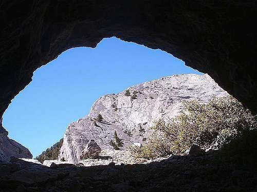
...On the initial stages of the downclimb, the mountain offered me another special surprise at the entrance to a small cave near the saddle that went unnoticed on my ascent. I did not have my flashlight with me, of all the times, but the western sun enabled me to explore it a little inside. There was room for my backpack and me but not much else. The cave entrance directly faced the highest point of Currant Mountain, so I snapped some neat pictures from inside the cave, and it descended to a smaller diameter hole that appeared risky, at which point I headed out. I returned to the next mountain south, where I retrieved my walking sticks and visited its summit. The looming descent down the dangerous slope could be procrastinated no longer, and I began it with a pattern of ginger steps down from rock to rock maintaining all the friction I could. It was tedious work and I still could not avoid momentary slips and slides that left scrapes on my legs and cuts on my bare hands. This repeating process lasted longer than the ascent, but I did finally reach the meadow safely and much to my relief. I finished some more food here knowing my toughest work was complete.
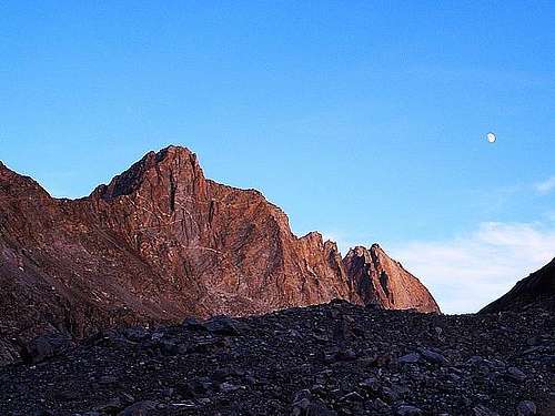
Mount Moriah, Nevada
...The Hendrys Creek Trail follows the namesake stream all the way to the east face of Mount Moriah, but it is a fairly long approach. It never really leaves the side of the creek, so it provides a steady and constant ascent for about eight miles to the mountain. The first of these miles begins in the arid sagebrush steppe on the east edge of the range. Sheer walls of fractured and blocked rock faces border both sides of the creek valley up to a few hundred feet high, and vegetation is limited to a few pines and areas of brush near the creek. Once I had followed the creek for maybe two miles into the wilderness, the elevation had increased enough to harbor thick pinyon and juniper forests. The trail in places was a carpet of pine cones that almost caused me to slip and fall a few times. Where the forest offered me a glimpse, I could see the canyon walls really closing in and narrowing the creek valley. The rock faces were always vertical or near-vertical though, so I could not get a chance to climb them. As I hiked onward, the environment gradually changed again to a thick forest of bright white aspen trunks. Higher up, some parts of the forest canopy shined a bright canary yellow and others a deep sunset orange. These trees made up the bulk of the surroundings all the way up to the base of Mount Moriah. On the trunks of the aspen trees, I began to see many carvings of people’s names or initials. Most interestingly, it seemed like more than half of them were dated sometime in 1932. The branded trees looked much smaller and younger than eighty years old, so I learned that aspens apparently grow slowly. But as for the frequency of 1932 carvings, I know that President Franklin Roosevelt implemented the Civilian Conservation Corps very near that time. There must have been some sort of activity here during the Great Depression.
---
...I did reach the crest of the Snake Range just beside Mount Moriah’s shorter north peak. I was pretty sure at the time that the true summit was the more rounded peak to the south. I decided to go ahead toward that peak along what appeared to be a treacherous existing trail leading horizontally across the steeply sloping mountain face. Careful and steady steps were warranted here. This was the type of giant scree slope that, in the event of too much momentum down the slope, offered little chance to stop myself until the valley floor a few hundred feet below. I saw an example of this when my water bottle somehow fell out of my backpack pocket about halfway through my traverse of the face. All I could do was helplessly watch it tumble about one hundred feet down before it disappeared and apparently stopped behind a small outcrop. My only thoughts at this point were that I did not want to litter in the wilderness, and that I had used that bottle for a long time. So my only decision was that I needed to carefully slide down to try to retrieve the bottle. As long as I maintained friction and control, I could safely slide down. Fortunately, there were some large outcrops here that would enable me to climb back up. Using those two strategies, I was able to retrieve my bottle and work my way back up to my backpack sitting on the trail, thereby leaving no trace of litter. The action did leave me even more exhausted, if that were possible. The apparent summit was within my grasp now, so I plodded onward to the base of the last scree slope below the summit. I left the trail again and went directly for the high point against this final obstacle. Soon my pain temporarily turned to joy, because at the absolute summit, I found a rock shelter protecting a suitable place to camp.
---
...The physical discomfort worked in tandem with my eager anticipation of the stars to keep me from falling asleep. I benefited though by seeing a gorgeous sunset where somehow the entire horizon, 360 degrees around, was tinted in a pink haze that was just slightly brighter around the actual sun. I then lied back down and waited until blackness fell. My plan was to finally live a long-time dream of mine - stargazing from a high and remote mountain summit. This particular summit was over 12000 elevation, the sky was clear, light pollution was non-existent for hundreds of miles, and the new moon phase was in occurrence. It all added up to ideal stargazing. The light disappeared until there was a faint glow that persisted visibly through my tent. That was as dark as it would get because the glow emanated from the bright stars. The most amazing thing I saw was the clarity of the Milky Way ribbon across the sky. The contrast between the light of the galaxy and the dark areas within that band was remarkably vivid and detailed. It was not a blurry white haze here, but rather a web of bright white glows and dark empty spaces tangled together. It was simply amazing, probably as close to space as I will ever get. I went out of my tent and braved the cold wind twice more during the night at three-hour intervals. I got to observe how the constellations all rotated counterclockwise around the north star Polaris. The volume of stars visible was overwhelming, and at each viewing, it seemed like a different area was being highlighted with pristine clarity. With no extra light to hide shooting stars, I saw an abundance of them, never more than a couple of minutes apart. It was, by all measures, a wonderful and memorable night that satisfied my expectations. It was definitely worth my effort getting there.
Southern Snake Range, Nevada
...I took advantage of a random water spigot that was positioned near my campsite. In more detail, it was just an insulated pipe coming out of the ground near the bank of Hendrys Creek and a nearly steady flow of water poured out of it into the creek. I could not determine with certainty what the pipe’s purpose was, but I used it effectively as a shower. The water was chilly but I was able to get my hair and myself sufficiently clean and, as it turned out, dressed back in clothing with only a few minutes to spare. That is because, at the border of this extremely remote wilderness area, I surprisingly received a high-profile visitor. He was a scientist working on a geologic study for Stanford University. He came to study and observe the rocks in this part of the Great Basin, and had he arrived much earlier, he would have been treated to that and an entirely different kind of show as well. Before he went about his field studies, he offered me a suggestion to camp at the new Strawberry Creek campsites at Great Basin National Park.
---
...I encountered some sleeping bag trouble earlier. It seems I sleep so violently that I can cause the zipper to just disassemble itself. I am sure it has nothing to do with buying another generic unit back in that outdoors store in northern Michigan. During some handiwork, I changed the problem from one of being unable to close to one of being unable to open. To me, that is a successful fix. This morning, getting out of my modified, permanently-closed sleeping bag was a small hassle, but otherwise it worked great through the chilly night. I dug into another scrumptious granola breakfast and dressed for another day hike.
---
...I took my time and paused frequently to gaze at the views of Snake Valley. A clear line of sight from any elevated spot in these Nevada ranges will treat the viewer to incredibly spacious vistas. I am just entranced by them when I can see the points I have previously visited. Such points are many miles away and yet seemingly sitting there in easy sight right in front of me, like Mount Moriah or Notch Peak or the Schell Creek Range, as if I could walk to them tonight. The open spaces and the vivid colors in the rocks, sky, and sagebrush are key elements of what draws me so much to the eastern Great Basin.
![Windy Peak Summit]()
---
...I had to also stop in the modern small town of Baker to refill my water supply at the Great Basin Visitor Center, and to purchase what food I could at a tiny local grocery store. Once I was supplied and packed for the hike, I made my way to the Baker Creek Trailhead to embark on an overnight backcountry hike to Johnson Lake and Baker Lake. These were two alpine lakes in the general center of the park that I did not visit in my previous experience here. For no substantial reason, I started toward Johnson Lake first on the South Fork Baker Trail. This trail began aggressively uphill beside a rushing stream before it reached a level meadow and turned southwest. Here I saw a family of grouses strutting across my path and I settled into a comfortable steady ascent. After about two miles, the trail exited the forested surroundings and entered a large, wide-open meadow that offered terrific views of the high mountains within the Snake Range. Pyramid Peak from the east was magnificent scenery accented by the rich golden sections of quaking aspens bursting in color below the tree line. I got to walk under some of these pockets of aspens, and there, like a silent dream, the yellow leaves steadily rained down upon me from above. The trail crossed over a large west-east ridge at Snake Creek Pass just below 10000’ elevation, where it continued west beside the crest through spruce-pine forests and increasingly rocky terrain. Out of nowhere, I came across the well-preserved log structures of a former mill and cabin near Johnson Lake itself. It felt like stepping back in time to walk through the buildings, which must have been a century old. The cabin itself was a small functional house with one central room and presumably a storage closet, both sheltered by a tin roof, as well as an open-air enclosure littered with antique supply containers and weathered metal. The scattered evidence of former human habitation stretched right over to Johnson Lake, a very tiny and shallow pond nestled beneath a steep rocky ridge that surrounded it like an amphitheater. I thought my ascent was over, but it turned out I had to climb over that ridge above 11000’ to reach Baker Lake to the north. It was another one of those hikes up slippery ground without enough large anchor rocks available for stability, but I made it to the top and stared out west over Spring Valley.
Fishlake National Forest, Utah
This morning arrived in much the same way as the preceding evening ended, and that was in total silence. There is no wind, animals, or other people around here in the heart of Utah’s western desert. The bag of food I picked up by Great Basin National Park was not going to last me through the day, so I needed to continue east to the next significant town, which was Beaver, Utah. My car also needed an oil service soon, so I located a local shop to get that out of the way. They completed my oil change and I left for a short while. Then I returned to the shop and asked if they still had the engine oil dipstick that was missing from my car. The mechanic was a very nice guy and he felt sorry about it, but I was not upset and he gave me some information regarding the local national forests. It worked out kind of well, actually.
---
...The ridge offered me my closest view of the Tushar Mountains, still a wonderful view even in dreary gray light. From here, I cut through a pine grove and over a small sagebrush plain to a high point south of Cottonwood Road. The wind was really picking up now and the sprinkles were increasing in frequency. A classic cold front was invading and I could see rain on the horizon. I hastily finished my early afternoon lunch and, after discerning a route back to camp, I downclimbed my lunch mountain to what I assumed was Gold Gulch Road. I thought I could quickly follow this road back east to camp before rainfall. To my surprise, this particular road ended at a livestock watering hole. My only route east from here was a tiny dry creek bed. Like everywhere else I had hiked within this forest, there was no trail. But based on the topography, the east-running drainage would certainly lead me to the forest road I needed, so I followed the dry creek. Hacking through this part of the forest was an adventure. The drainage was narrow and filled with several pockets of brush or fallen tree trunks serving as natural barriers. In spite of the troublesome areas, there were some bright spots. None were literally brighter than the brilliant magenta and red leaves of the small maple trees I surprisingly found. The maples also sported pastel orange or yellow foliage, and while they seemed out of place here, they were pretty numerous in the interior forest. The deep gully kept me out of the wind as I resolutely blazed a trail looking for the forest road. It did eventually appear, although to my astonishment, I came upon it from the south side instead of the north. Having a map would prevent such miscalculations, but now that I was on familiar ground, it was a moot point.
Black Ridge Canyons, Colorado
...In a short time, I was parked at the Devils Canyon Trailhead on the edge of the McInnis Canyons Conservation Area, but I sat and waited a long time there through another period of rain. When the rainfall momentarily stopped, I sprang into action and entered the network of hiking trails with supplies to last me through the next day. It was now very late in the day with the western twilight diminishing by the minute. I only aspired to hike a quick half-mile past the Black Ridge Canyons Wilderness boundary and set up camp for the night. Unfortunately, even a brief hike of this nature was too difficult for me to complete here, because my trail forked and I guessed the wrong path. Soon, an endless web of paths went before me in every direction, and there were no guideposts or markers in sight. I must have veered off of the area illustrated on my hiking map. I hiked aimlessly for about thirty minutes and 0.9 miles, which was all that the twilight would allow, before setting my tent next to a few junipers in a renewed light rain. The rain continued well after darkness, and I could only patiently wait through it until morning, when I would try to ascertain exactly where I was.
![McInnis Canyons]()
---
...I only had food and water to last through the night, so during any hike tomorrow I would have to ration supplies. Of most immediate threat was the weather. The horizon showed strong indications of more rain, which had mostly held off so far today. While weighing all of this in my mind, the dominant sentiment was my desire to see the arches. I postponed a decision and started west on the Rattlesnake Arches Trail until my turn-around time at 1:30, when I had just passed a sign showing four more miles to go. The weather was unfavorable and there was no avoiding it at this stage. A light sprinkle had already returned. Ultimately, it was new confidence in the trail navigation and some twisted logic that convinced me to press onward. I was going to be wet either way because I was a long way from my parking lot, so I may as well see the destination I really wanted to see.
---
...Within about two miles of the arches, I really second-guessed my decision. At this point, the weather really increased its resistance. The wind on this exposed mountain was constant and the heavier rain soaked through my clothing. I learned not to fight the weather once already, but here I ignored the lesson, as I was overcome with impatience from the many continuous days of desert rain. Like a true villain, the elements just seemed to fight harder as I got closer. When I reached the Rattlesnake Arches area, the first arch looked so appealing as a shelter. I gingerly climbed down off-trail to get inside it, and on the lowest face next to the arch, I slid into the dry cover with a barely-controlled fall down the rain-soaked slick rock. After all of the tough effort to overcome the obstacles and discomfort getting here, I was thrilled at reaching my destination, and the scenery blew me away. The arch shielding me from the rain looked symmetrical, almost as if it was sculpted by precision. It and the Rattlesnake Canyon walls nearby were a blend of pale brown and light garnet sandstone layers. On the canyon floor, at the bottom of the steep slick rock slide extending down from the arch, junipers and pinyon pines contrasted in a rich dark green color. Courtesy of the persistent rains, I had one major treat in front of me during my meal. A beautiful waterfall cascaded down the vertical canyon wall. I tried to line up a few neat photographs from my vantage point looking through the arch at the cascade. I was at the arch long enough for the rain to suspiciously trickle to a halt, as if it knew I had reached my goal and our battle was over. My next battle was to get out of the arch and back above the canyon rim on the wet and slippery rock. This was very tricky, almost to the point of getting ledged up and being stuck there until the rock dried. My entrance route was too steep and not an option. A fairly steep slope on the west side of the arch was protected by a ledge underneath, so I tried that for a short while. But each time, I ended up sliding down to the ledge with scraped hands or scuffed clothes. My lifeline was a short exposed rock face leading to the top side of the arch. It came with the risk of a dangerous tumble through the arch all the way down to the canyon floor. But it appeared to be my only option because of the slippery conditions. I tossed my gear up, summoned some courage, and made the running leap on top of the wall. It was one of the most dangerous things I have ever done. I had made it out, although descending into the arch with these wet rock conditions was certainly a risky decision to begin with. It was just one on a day full of them.
![Rattlesnake Arches]()
---
...I was not worried or frustrated regarding the rain last night, but that quickly changed about an hour before sunrise. Once again, a steady dose of prolonged rainfall took hold, and this time my tent could not meet the challenge of repelling the moisture. Water was coming into my tent enough to create pools in the low ripples of my canvas floor. I created a low depression to hold the incoming water, and then I lied down to rest. I was intent on waiting this out. My intentions lasted until about 10:00, when I was out of food and very nearly out of water for my remaining hike to the trailhead. The rain lasted a little longer than that. Reluctantly, I gathered my things and stepped out into the mess, where I packed the dripping wet tent and tried to start back. But the nasty-looking abrasions across my left Achilles area were extremely painful and stopped me in my tracks. The accumulated wear on these socks and hiking boots must be aggravating the problem. The abrasions were especially tender, and I had to grit my way through the remaining return hike. The physical ailments are threatening to call a premature end to my travels before the full onset of winter has its chance to stop me. I can just camp tonight and await tomorrow. Maybe it will still be painful to walk or maybe I will be able to relentlessly march up and down the plateaus. But I am sure in either event that it will rain, here in the equatorial rainforest jungles of western Colorado.


Comments
Post a Comment