
|
|
List |
|---|---|
|
|
The Long Trail
In the spirit of the Appalachian Trail Mountains page, here are the mountains of the Long Trail.
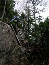
Completed in 1930 the Long Trail is the oldest long-distance trail in the United States. At 270 miles the LT, as it is known, runs peak to peak to peak along the ridge of the Green Mountains from the Massachusetts border to the Canadian border, and provides the hiker and backpacker with a beautiful backcountry trail and access to many of the Green Mountain's best areas.
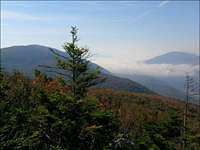
The Green Mountains are a part of the much larger Appalachian Mountain chain running the length of Vermont and continuing north and south into Quebec and Massachusetts. Vermont's 160 mile portion varies from 20 to 36 miles wide. The highest peaks are above 4,000 feet.
Three alpine tundra areas can be found on the higher peaks. These rare environments mimic species found 1500 miles to the north. Mt. Mansfield (highest in VT) has the largest tundra zone at 250 acres. There are another 10 acres on Camel's Hump and a small patch on Mt Abraham.
For more information about the Green Mountains see Summit Post's own Green Mountains range page.
The Trail and the Mountains

| Table in progress... | |||
|---|---|---|---|
| Name | Height (ft/m) | Side Trail | Side Trail Distance |
| Canadian Border | |||
| Battell Mtn | 3482 | no | |
| Mt. Boyce | 3323 | no | |
| Worth Mtn | 3234 | no | |
| Gillespie Peak | 3366 | no | |
| Cape Lookoff Mtn | 3320 | no | |
| Mt. Horrid | 3216 | no | |
| Killington Peak | 4,241 | yes | .2 |
| Baker Peak | 2,850 / 869 | no | - |
| Peru Peak | 3,429 / 1,045 | no | - |
| Bromley Mountain | 3,260 / 746 | no | - |
| Spruce Peak | 2,040 / 622 | yes | 300 ft |
| Stratton Mountain | 3936 / 1200 | no | - |
| Glastonbury Mountain | 3,748 / 1,143 | no | - |
| Consultation Peak | 2810 / 857 | no | - |
| Massachussetts Border | |||
Much of the LT in Vermont is really a narrow strip of protected land surrounded by private property. Pay attention to signage and guidebooks regarding private property and camping restrictions.
On or near the trail are 25 shelters, camps, or cabins. The standard shelter is a 3 sided affair with wooden floor and sometimes a picnic table in front. They sleep 6-8 usually. Cabins are just what the name says, log or frame cabins often with glass windows. They can be very nice and any are welcome in a storm. There are all different sizes. LT camps are structures that are open tosome degree but much more like a cabin than a shelter.
For more information about the AT/LT and the Green Mountains see Summit Post's own Green Mountains range page.
End to Enders
Backpackers completing the whole trail whether at one time or over a span of years are called End to Enders. About 70 people per year successfully complete the entire trail and become end to enders.
Thruhikers generally start in summer and take about a month to complete the hike. The main concerns when planning an end to end hike are mud season, black flies, and snow. Each of those is better explained on the Green Mountains page linked above.
This year's Long Trail thruhiker journals
Movies
Here are a few movies from an Oct 2005 north to south thruhike of the Long Trail.View from Stratton Firetower
View from Bromley Lookout
View Camel's Hump (inclement weather)
Climbing Mt. Mansfield's Chin #1
Climbing Mt. Mansfield's Chin #2