
-
 33763 Hits
-
 73.06% Score
-
 3 Votes
|
|
Route |
|---|---|
|
|
39.64280°N / 105.8208°W |
|
|
Hike w/ some scrambling |
|
|
A long day |
|
|
M1 |
|
|
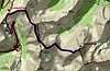
Approach
Coming from the east down US Highway 6 on the way to Arapahoe Basin Ski Area you will go through Loveland Pass (elevation 11,990 feet). At the top of the pass on the left is a parking area. Park here and proceed east out of the parking lot up a steep hill and following the Continental Divide.
This route is also known as the West Ridge route.
Route Description
Hike uphill. The route has several trails that intersect it, but stick to the most worn and obvious one running up the middle until you reach the summit of a 12,000 foot peak. The trail turns right and heads southeast down onto a saddle and back up another 12,000 foot peak. Some scrambling is involved here. Be careful of the drop off on your left. There aren't many cornices but the rocks are not all that stable in places.
Decend into another saddle and up 13,000 foot plus Grizzly Peak. There is a very nice campsite at the top with a stone wall windbreak built up about two-three feet. The trail will turn more eastward although it will zig and zag by switchbacks quite a bit. The trail is almost not discernable in places, but continue moving downhill into a wide and grassy saddle between Grizzly Peak and Torrey's Peak. There are several abandoned charcoal campfires here. A series of switchbacks lead to the summit, but the trail is hard to find once you get near the top. On the return, during winter, there is an obvious broad shallow snow gully to the right of the trail that makes for an exciting glissade back to the grassy saddle.
Navigational Info: Gray's Peak will be visible just south of Torrey's Peak for most of the trek. Also, you can see the Arapahoe Ski Parking Area from nearly anywhere on the route. The highway is also useful because it to can be seen (and heard) from nearly anywhere and can be used as a reliable landmark for taking compass bearings.
Other Info: There is also a shortcut from Grizzly Peak to the Loveland Pass Parking area that bypasses one of the two 12er's on the route. This shortcut lies just south of the first 12er you come to heading out of the Loveland Pass Parking area.
Length: 4.5 miles one way.
 |
Essential Gear
Good boots, ice axe. No tools or pro needed. The route is dry in places so unless there is recent snowfall or icing, crampons aren't needed.
Miscellaneous Info
If you have information about this route that doesn't pertain to any of the other sections, please add it here.
marcminish - Sep 10, 2002 12:44 pm - Hasn't voted
Route CommentThe correct road is US Highway 6.
Thanks!
mpbro - Sep 19, 2002 8:51 am - Hasn't voted
Route CommentRoach calls this route the "West Ridge", but I like Loveland Pass too. Maybe to be fully descriptive you could call it "West Ridge from Loveland Pass". Strictly optional. Nice work.
jacksonr - Sep 29, 2002 9:00 am - Hasn't voted
Route CommentLoveland pass is about 11,990. The first two summits you mention as 12,000 are more like 13,000. I was caught bwtween these two 13k peaks in a thunderstorm and elected to side-hill south to the road. This was unpleasant and the driving rain didn't improve the situation.
marcminish - Sep 30, 2002 7:09 am - Hasn't voted
Route CommentDo you know the exact altitudes so I can add them to the route? I appreciate info and will add any elevations you can give me. Thanks!
marcminish - Sep 30, 2002 7:12 am - Hasn't voted
Route CommentI added the Loveland Pass elevation.
Runstacy - Oct 9, 2016 10:35 pm - Hasn't voted
QuestionAny ideas on the mileage if you were to walk from the parking lot straight up to the top of the mountain?