Overview
This route is, in my opinion, the best route to climb Brandon as part of, seeing as at various points along the route, you can see East back toward Castlegregory and Slieve Mish, West towards An Daingean, Smerwick Harbour and the Blaskets, and finally, down the cliffs on either side of the Faha ridge, that connects almost perpendicularly to the route just to the North of Brandon proper. Great views down into Lough Dubh (N. side of Faha ridge) and down the Cloghane (normal) route (S. side of Faha ridge) can be seen as one hikes up to the summit proper, and the cliffs are quite sheer. The final traverse of the ridge down from Brandon and on past Brandon Peak is a nice airy ridge walk, with (if the weather holds) fantastic views in all directions.
Getting There
Follow the normal route to Cloghane village. Keep going through the village in the direction of Brandon village. About a mile out of Cloghane, the road will take a dog-leg turn to the right, with a minor (very minor - almost a track) road continuing straight on. This rapidly becomes a rocky track. Follow the track as far as it goes. The track finishes up at a Stone-built shed with a green roof, and there are signs for the Pilgrims Path up toward the ridge and Piaras Mor. This is the beginning of the walk. Más-an-Tiompáin is to the immediate right of the Pilgrims route and can be easily added to this ridge walk.
Route Description
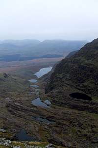
[img::alignleft:small:]Follow the pilgrims path (signposted )up to the ridgeline, where views of the Blaskets can be seen in the far distance. Once up to the ridge, turn to the left and follow the ridge toward in a south-westerly direction toward Piaras Mór and further on, Brandon. On the route, you'll have spectacular views down over Lough Dubh, the Faha ridge and the Cloghane Route, with its chain of Paternoster lakes. Once Brandon summit is reached, either descend by the Cloghane Route or continue on Southward toward Brandon Peak. Beyond Brandon Peak, you can either follow an airy arete back down to the valley or continue following the entire length of the ridge back toward the Conor Pass (this will take about 3-4 hours i think).
Essential Gear
Brandon gets low cloud and rain the vast majority of the time. It can also get extremely cold and windy. Always bring adequate wet-gear, fleeces, gloves etc, as well as a map, compass, and whistle. When attempting the walk, expect bad weather. You may be pleasantly surprised, but don't expect to be. Brandon and its neighbours possess some of the most sheer cliffs that there are on Irish hills, so be aware where you're going at all times. In fog, a misstep or slip could quite possibly prove fatal.

 9134 Hits
 72.08% Score
 2 Votes