We arrived in Calgary after several months of collective planning. Cooper, Jim and I had spent a single session all together practicing elements of crevasse rescue. I had been hoping for this trip for years. Our main objective was to be a mountain called The President via the northern President Glacier route, which I had found in researching moderate glacier mountaineering routes in Canada.
By the end of our first day in Canada, we were all blown away from the Canadian Rockies. The craggy peaks of the Kanaskis surrounding our home base for the trip, Canmore, are remarkable. We'd already stopped in Calgary to finish up our last minute gear shopping and finished by picking up groceries in the markets of Canmore. We had reservations at the Canadian Alpine Club Clubhouse for the entire week, hoping to spend a couple nights in backcountry campsites since the Yoho was booked full. The clubhouse is the most fantastic hostel imaginable, and is highly recommended for any trip to the area.
We had a bunkmate that had been evac'd off the Columbia Icefield during an intro course. He looked pretty rough, and told us that he "had a complete physical and mental shutdown". Ouch! He was a trooper, and was planning on taking another stab at it before he left town.
Our early start into Yoho Valley the next day proved to be a fruitless effort, as we spent a couple extra hours waiting for the park offices where we could purchase a park entry pass. After finally obtaining it, we drove to the trailhead and headed into the backcountry under the spray of the giant Takkaka Falls, which was the first of several impressive falls on the route to the Little Yoho campground.
The approach was a bit more burly than I was expecting, but a fairly quick endeavor to the tent site a 100 feet below treeline next to a glacier fed stream on the edge of an alpine meadow. We arrived and set up camp quickly and were soon down for a much needed nap. I woke up after a nice hour snooze and restlessly made my way up the trail to treeline for the first view of the President Glacier. I continued up the maze of talus and scree to the glacier's edge to survey the route for early the next morning.
By the time I made it back to camp, Cooper and Jim were stirring and leisurely prepared dinner. It was during this feast that we realized that some of our food was missing, Cooper remembering that his saw a grocery bag left in the trunk as we left the parking lot. The fact that we'd left 30% of our food behind sealed the deal that we'd most likely spend one night in the backcountry, or two at the absolute max.
Up the North Glacier
The night was uneventful, except for a kid screaming like mad in the next tent site. Something about loosing something his "Gammie" gave him. Not sure really, I'm a heavy sleeper. I don't think Jim and Coop were as fortunate...
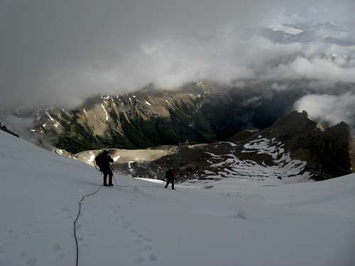
Our alpine start began at 3AM which worked out perfect as we arrived at the glacier just as the sky started to illuminate our route. In the dark approach, we became aware of the full value of my reconnaissance the afternoon before. The route finding through the small cliffs would have been very time consuming without the beta acquired 12 hours earlier.
A fantastic glacier climb up the snowy ice slope and crevasses brought us to the monstrous bergshrund that we were able to pass on the right via a steep slope to a belay in a much smaller crevasse threatened by a cornice hanging off the East Ridge of the President peak, our planned route of ascent. An exposed traverse across a steep slope put our rope team onto the President Col as the weather that we'd been monitoring to the peaks to the North built to block our views of the smaller peaks across the valley. With the thought of the steep traverse and downclimb in a total whiteout, it is here we reluctantly considered this the end of our route for the day, a half hour shy of the peak's summit.
Racing the Clouds Down
The descent was exciting through the steep and exposed slopes, which led to a gentle stroll back down the glacier, constantly looking back at the peak second guessing our conservative decision. The coming storm arrived as Cooper and I made it back to camp after a spooky log crossing over the river. Jim elected to take the 20 minute longer walk around to a bridge a few hundred meters downstream, which led to him hoofing it out for a few minutes in a downpour of hail and lightning that lasted a bit over an hour before a break long enough for us to pack up our soaked camp and start our descent back toward the trailhead. The soaking wet descent was uneventful unless you count my total misery with a giant blister that crippled me to the point of hobbling, and at times nearly crawling, before finally making it back to the car.
A scenic drive back to our home base in Canmore was a delight, stopping for wings, pizza and beer en route. Once back at the cabin, we scoured the guidebooks and resources there for an easy ascent the next day, finding the West Slope of of Chinaman's peak, a.k.a. Ha-Ling Peak, overlooking Canmore. This proved to be an excellent choice for an easy half day hike for us as we included the next couple small peaks just South of the peak to a couple lesser summits. The descent was comical as we hiked down, as other groups were coming dressed more like a Jana Fonda exercise VHS tape, complete with pink tights, sports bras, and hand carrying brightly colored water bottles. Needless to say we felt like major wimps as we passed them with full kits, including shells, maps, a compass and trekking poles.
A small peak near Ha Ling
We planned a more technically challenging option for our last day climbing, the North Glacier of Athabasca to Boundary Peak, which required a painful 11:30 PM (that's right PM!) wake-up for the long drive before an alpine start. A surprisingly short approach, where the only challenge was route finding in the dark, put us on the toe of the glacier. We were surprised with nice steep climb up bullet hard ice, roped up as a glacier team which was not a good idea, as stopping a fall would be impossible. It got steep enough where belayed pitches were the only safe option, but we'd neglected to bring enough ice gear use this method, so again we made a tricky descent down to the talus field below the glacier, where we watched another pair of climbers ascend another portion of the glacier past avy fracture lines to the North Ridge.
Icy North Glacier
A quick car tour, were I saw more glaciers than I've ever seen in my life, of this portion of the Icefields Parkway wrapped up our mountaineering trip. As I sit here a few months later typing this, listening to Eminem on my headphones as on a long flight home from a work trip, I'm feeling the need to go back and stand on the top.
Parents refers to a larger category under which an object falls. For example, theAconcagua mountain page has the 'Aconcagua Group' and the 'Seven Summits' asparents and is a parent itself to many routes, photos, and Trip Reports.