
-
 1950 Hits
-
 74.92% Score
-
 5 Votes
|
|
Route |
|---|---|
|
|
46.41282°N / 13.48509°E |
|
|
Download GPX » View Route on Map |
|
|
Hiking |
|
|
Spring, Summer, Fall, Winter |
|
|
Half a day |
|
|
Easy hike up (on top some more care needed) |
|
|
Overview
This is an easy ascent over the southern, grassy slopes of the mountain. In summer, it can be very hot. The route nicely combines with the ascents by ferrata Ceria Merlone (from both sides), offering a quick and safe descent on the southern alpine meadows. On the Swiss Hiking Scale, difficulty of most of the tour is T2, only the final ascent is T3. 2 h 15 min. You wouldn't believe, but the tour is done by some experts also as a mountain bike descent.Getting There

Biking over Altipiano del Montasio

Casere Cregnedul di Sopra
From the big parking place it is best to go to Casere Cregnedul di Sopra by mountain bike. You first ascend some 50 meters to the crossroads, there turn right and ride by a slightly descending road by Casere Parte di Mezzo and Casere Larice. Till there you may be lose only some 60 meters, then the road runs again only slightly up till Casere Cregnedul di Sopra. Unless being a true mountain bike expert, leave your bike there. 30 min (1 h on foot).
Route Description
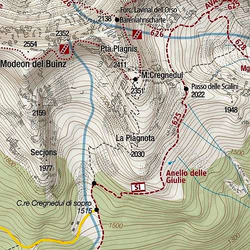
Ex military trail is marked with black, dashed line

Remains from the WWI
The grassy slopes of Cregnedul are in early summer abundant with flowers of all kinds, so the ascent can be very nice. By those grassy slopes you gain the altitude of some 2200 m, where above you the first higher rocky barriers start rising. Climbing them would mean ascending Monte Cregnedul directly, but the path now crosses the slopes left, going up by the western slopes of the mountain. By comfortable ledges and a few more steep ravines the path gains another 100 m of altitude and in front you already notice the rocky castle of Punte Plagnis and the distinct notch right of it. There ferrata Ceria Merlone comes, but even before our path gets to that point, you turn right and without bigger problems (some more steep slopes require some care) ascend the summit with a big ciarn.
See also the GPX track in the header (the last turns should be coming more from the southern side).
 On the southern slopes of Monte Cregnedul |  The towers, guarding the passage on top |