
-
 5905 Hits
-
 81.18% Score
-
 13 Votes
|
|
Route |
|---|---|
|
|
46.61671°N / 12.24262°E |
|
|
Download GPX » View Route on Map |
|
|
Hiking |
|
|
Summer, Fall |
|
|
Half a day |
|
|
Medium hard hike up (T3) |
|
|
Introduction
This is a beautiful ascent route on the plateau of Monte Piana/Monte Piano from the west. While from Misurina taxi brings you on the plateau, from here you must do the whole altitude on foot. The path was built even before the World War I, when in Carbonin/Schluderbach tourism started. During the Big War Austrians were using the better protected northern supply route, while Italians had anyway the road from Misurina. The Touristensteig goes in many turns more or less straight up a steep forrested slope, shady in the morning and with beautiful views on Val di Landro / Höhlensteintal and on the mountains above it.General Information
Source: Kompass maps online
Exposition: Some sections are exposed, but there the path is wide enough and also protected with cable.
Orientation: Easy. The path is well beaten, marked (No. 6) and there are no substantial other paths deterring. See the GPX track in the header!
Slope orientation: Till the exit on the plateau the slopes are west oriented.
Objective dangers: In the section of the big ravine, due to very friable rock there is some danger of rock fall.
Best season: Summer months, normally from June till October or till the first snow.
Gear: Good shoes and poles are sufficient. People, suffering of vertigo, could use a ferrata set only in a short section - some 100 m of cables across the ravine.
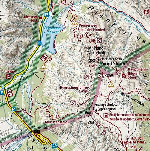
Tour start: The best option is on the bridge over Fonda creek (Ponte della Marogna), 1470 m, where you can find also big, good parking places. That's the old start of the path, which is today almost completely abandoned. Only a weak path goes along the creek on the right side - follow it, and you will soon hit the official path. This one starts a bit lower down by the main road, towards Carbonin/Schluderbach.
Highest point: 2324 m, the summit of Monte Piana.
Altitude to overcome: It's around 880 m (crossing the ravine, you lose some 30 meters), otherwise it's only up.
Time for ascent: 3 h to any of the summits above Monte Piana / Monte Piano plateau.
Map: Tabacco. Cortina d'Ampezzo e Dolomiti Ampezzane. 1:25000.
Route Description
By the bridge over Fonda creek (Ponte della Marogna), 1470 m, you find the tiny path along the creek right bank. The path is seen from the bridge, but is not marked at all. Follow it some 300 m, then you hit the well beaten, marked Touristensteig / Sentiero dei Turisti (No. 6). Follow it right, up the hill.Well, this path is really not doing any compromises. In many turns it goes more or less up the hill, it goes on some places more left or right just to find the best passages over the steep, forrested and also rocky terrain. After gaining some altitude, first a great view opens on Carbonin/Schluderbach and on the majestic Croda Rossa / Hohe Gaisl above it. Soon afterwards we get on the more southern edge of the forrested rib, and great views on the northern walls of Monte Cristallo open. And a bit higher, when crossing more northwards, wonderful views along Val di Landro / Höhlensteintal and on the small Lago di Landro / Dürrensee open. These views are not available to the tourists, coming from Misurina, until they reach the edge of plateau on Toblacher Kreuz.
 Monte Cristallo |  Hohe Gaisl / Croda Rossa |  Lago di Landro / Dürrensee |
Otherwise we ascend through the woods. Along the path there are not so many World War I remains as along the northern approach, which was the main Austrian supply path for the frontline. We must do more than half of altitude, before the scenery changes. There the path comes around a forrested ridge and a big, ugly ravine opens in front of us. From a distance it looks bad, but we soon meet the first cables, which assure us, that the path will be protected also on some quite easy passages. It goes by on some places narrow, on other places broad enough ledges, cut in rocky slopes. So, we easily reach the inner corner of that rubble chaos, but there even a short descent awaits us. In a ravine corner, where falling rocks must be permanently destroying the path, there are good, wooden steps, accompanied by a chain (see the picture below). After descending some good 20 meters, the path turns up again. We carefully cross also the second part of ravine and reach the slope, overgrown with pine bushes and trees. A few more turns up, and a nice view back on the picturesque scene opens.
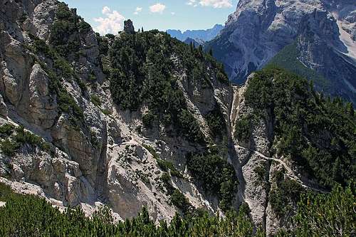
The path crosses the big ravine (to see details, open original)

Exiting the W slopes
From the saddle of Castrati we take any combination of the marked paths, which visit both summits (15 minutes) and key positions of both armies during the World War I. A round tour is most recommended. See the main page for details! In that case the combination and the return is not any more a half day tour.
Return. By the same route. If we want to combine this route with the northern approach (Pioniersteig - Sentiero dei Pionieri), this route is more recommended for a descent. If you go down to Misurina by the road (or taxi), then you have quite some distance to cover by road down to Schluderbach/Carbonin.