
Comments
No comments posted yet.
|
|
Trip Report |
|---|---|
|
|
19.67831°N / 98.2049°W |
|
|
Download GPX » View Route on Map |
|
|
Dec 21, 2021 |
|
|
Hiking, Mountaineering |
|
|
Winter |
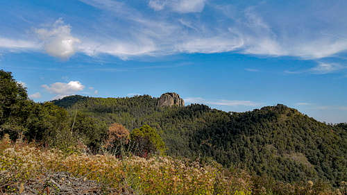
In an attempt to make the most of my short vacation time, I intended to take a trip in which my main objective would be to reach, first of all, the top of “La Malinche”, which is something like the sixth or seventh highest mountain. of the country, although its isolation and prominence give it a special place, perhaps akin to its geographic location among the country's top 5,000. I already had training, but I needed to acclimatize, get in shape after spending much of the past few months in front of the computer. Almost a year had passed since, on this same mountaineering page, I had read the article on the Rock of Rosario; the photographs immediately attracted me, due to the apparently illogical greyish white silhouette of the rocks in the middle of the emerald green forest of oyamel. What was most curious to me was that he had passed by before, without paying attention to it. I inquired to obtain current information on the area.
It turns out that it is a park, El Rey Natural Park. I don't know the reason for the name, because the place is known locally as "El Peñón" or "El Peñón del Rosario" before Peña del Rey, but it should not be so important. What yes, is that the web page mentioned that, to access, it was only possible on the dates that the site administration planned for ascents and camps for the general public, each experience with an approximate cost of $1200 Mexican pesos (~56 US dollars to date). The price and experience seemed reasonable, but my times didn't fit, and my funds were insufficient. I decided that, due to the geographical location of the elevation, it was a good idea to arrive better from the Puebla side, through some town to the north or east, instead of the faces that Tlaxcala offers, the other state that this place divides. In this way, perhaps, he would be able to avoid entering the facilities, if any, of the park, and would ask the people of some town at the base of the hill for permission.
I knew superficially that part of Tlaxcala and Puebla, bordering Hidalgo through the Llanos de Apan. The circulation roads for the buses went to Apizaco, Tlaxco and Chignahuapan taking big curves that seemed to me to be extremely tangential to the route, lengthening the time I had planned when I left CDMX early on December 21. Unfortunately, there was also an accident and heavy-duty traffic jamming the highway. Originally, I would have liked to climb the Rock that day, to get to sleep in Puebla and climb Malinche the next day. I didn't want to risk falling prey to darkness on those short winter days with freezing, windy nights. So by the time I was heading to the last destination of the bus. I ate abundantly in Chignahuapan, and bought food for the next day to try to climb Malinche. I booked a bed in a hostel in Puebla, quite comfortable. I asked for reports. They kindly informed me that, to climb that mountain, I had to leave Puebla between 5:30 and 6:00 am to arrive in Apizaco on time, where I could board a public transport to the IMSS Malintzi Vacation Center on the slopes of the volcano. I slept well, to get up early. I arrived early at Apizaco, but in my failed attempt to timely decide which of the two "Elektra" was the base of that transport, I lost the 5 valuable minutes that separated me from the exit. The next was many hours later, in the afternoon. It was no longer feasible, and he had given up going up Canoa out of the same concern of not knowing the place. It was early, and getting to Tlaxco only cost me $14, a good deal. I went up and at 9:30 a.m. I was in Tlaxco.
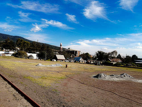
For a magical town, it was pretty empty of people. I thought it was very nice. In the transport I saw the need to ask a person about the town called Acopinalco del Peñón, especially how to get there. He turned out to be an inhabitant of that town, and he helped me punctually to trace the itinerary to the base of my route in the GPS. Beyond that, he told me that some important Mexican movies had been shot in Tlaxco and El Peñón due to the settings that were the environment. I believed him, because it seemed to me that the pastures and piles of harvested corn had some of the best yellows I had ever seen, with solitary pinyon pines providing occasional shade. It was dry, but did not appear to be desolate. I liked the fact that Tlaxco produces large quantities of different qualities of artisanal cheeses. The central park was clean and spacious. There I found the Restaurant-Bar El Rincón Taurino, which was the reference to take the transport to the Rock. Lastly, the man told me that there was no problem with me going up the hill through the town and its ejido forest area, because in case I was questioned, I could mention his name as a reference and his address for any emergency. . He stayed in Tlaxco to buy his groceries, while I boarded the bus to the little town. I don't remember how much I paid, but it was extremely cheap, under 15 Mexican pesos. It was very fast, and I got some beautiful views of my destination.
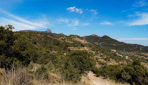
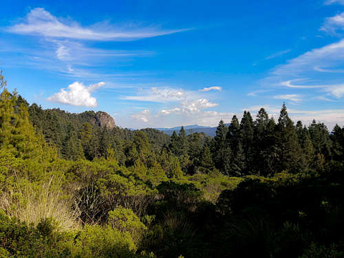
The emotion had not prevented me from putting the GPS into operation, which, as soon as I got off the subway towards the indicated path, began to record the gpx file attached to the "trip report". In the street, people just looked at me with curiosity and distrust, but slight. I quickly passed the populated area, and arrived at the dirt road winding up the first hill, still covered with farmland, although with remnants of the original vegetation, based on Juniperus and Pinus. The rocks looked to the north more and more clearly, more real and tangible for my eyes so full of disappointment last day. I was progressing very quickly through those lands with little steep slopes and regular traffic, evidenced by the manure of many cattle that go up and down carrying firewood after eating in the pastures. I was on those lands around 10:00 am, under a sun whose rays diminished in intensity in the following 40 minutes, since I had entered the forest. The strawberry trees stood out, Arbutus, redder than I knew them. In some small clearings the rocks could be distinguished, nearby, under the clouds cut by the wind. The mosquitoes bothered us for a long time, until shortly before reaching the fir forest at ~3000 meters above sea level. I got lost on some trails despite bringing the GPS device, to appreciate the forest. The contrast was enormous, from cities so limited in space and air quality, to silent environments, but full of life thanks to the abundant rains of the past season. In fact, rainfall continued occasionally. I crossed a clearing in the forest caused by a possible logging, which had produced the existence of a thicket in competition with an exuberant grassland of large tillers, exceeding 1.5m. The view rewarded the effort. A large rock appeared that, by itself, represented a good point, although in the background, despite the distance, the largest stood out.
I did not stop to rest, because the path was very simple, it allowed me to gain a good elevation, and see the great rock in profile. When the forest began to dissipate, a small peak soon appeared, the first among several rock formations, where the Pueblan part of the park could finally be seen. Among the rocks there were good places to make controlled fires, or establish camps. In any case, it was already noon, I had been on the road for two hours and I couldn't waste time. My water reserves, as on other occasions, were alarmingly scarce. In lands like this it was not easy to find water, more than in the ravines, in practice it was not feasible to get it. I decided not to complain about the water, because the sacrifice would only last, at most, 2 hours.
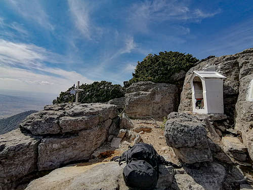
It was still a relatively morning walk. I better keep going down the path. The smoothness of the slope was broken by the first ladder that had been installed to avoid the effort of climbing the medium-sized rocks. Then the path began to skirt the rock, narrowing and being limited to the left by junipers. Going down, the fall was dangerous, as a drop of more than 300 meters was noticeable, with slopes greater than 50°. It was easy for me to understand the need to use the helmet, harness and rope, plus carabiners. Still, with due caution, and prior experience plus situation-level responsibility, progress could be made serenely. The most difficult sections had a greater mental impact because the exposure increased quite a bit with each meter that was progressed vertically, being able to feel vertigo when seeing the fall towards the precipice. In addition, it promised to be a relatively isolated peak from the rest of the elevations. I finished guessing the last stretch of the road, and progressing through the last stairs until I reached the summit. The plateau seemed to me like a cozy coniferous garden. The wind was refreshing, competing closely with the midday heat. I walked to the extreme eastern part of the plateau, where the predicted cross was located along with plaques and a religious shrine.
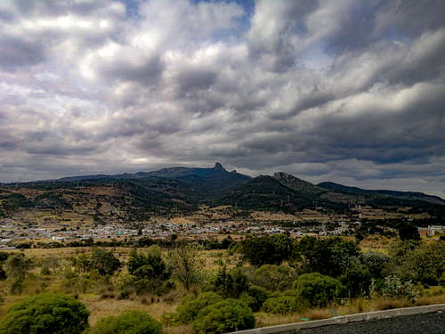
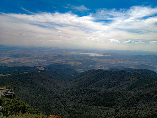
I put down my backpack, drank, and rested for five minutes while trying to get precise geographic and spatial data on my location. Only in this way would I know which were the large rocks that protruded from under my boots, aligned with an east orientation. At 12:30, which was about the time I reached the summit, the weather was still stable. Towards Malinche the landscape was blocked by clouds that were condensing in the afternoon heat, preventing me from seeing the volcanic cone. Much more visible, as well as much of the way, was a large body of water, called the Laguna de Atlangatepec, further south than the Rosario. It must have been at a midpoint of the Sierra de Tlaxco, so the panorama was divided into two sections, one to the north and one to the south. To the south was Tlaxcala, barren and apparently dusty. The Atlangatepec Lagoon, commonly known as "Atlanga", was clearly distinguished, like a large mirror. At greater distances, the weather was influenced by Malinche, hidden by the clouds that condensed on her skirts due to the midday heat. Tlaxco looked like the sleepy little town it appears to be from the highway. The geology of the place, strange, was the one that in effect could appear to be a larger space than the real one, due to the enormous variation. And it is that looking north, with trends to the northeast, the landscape was broken in the Sierra Madre Oriental. Although the change was not, visually, as violent as the one seen from Pico de Orizaba, it marked clear slopes to lowlands, certainly tropical, towards Veracruz. Suddenly I thought that, in the aridity seen to the south, I had seen numerous magueyes, so the production of pulque must prosper. That, a beer, or a juice would solve the crisis on my parched lips.
I continued enjoying myself for a while, taking pictures and videos to analyze them comfortably one day when I had time, when I was safe at home. I had to think again about the way in which I would undertake the descent. I had mentioned that it had become risky without the necessary equipment, it didn't take long for me to sweat in addition to what the sun caused. However, the belay points were firm, and I had no other life to take care of but my own, so the freedom in my movements gained confidence. I descended quickly to the last place where there was flat and extensive ground and terrain. There I rearranged the inventory of my backpack, because I finally felt safe. When replacing the GPS batteries, and turning it back on, I used a different loaded route than the one I had used to get there, without realizing it. My idea was to go down the same path, since I had already been there, not to mention that it had indeed been fast, but I took a route that I had previously seen on the computer. When I realized that I was going down another path, and wanted to return, it was too late. It was not a difficulty, it should be noted, more than in the extension of the road.
My water supplies ran out at the end of the oyamel forest, while descending the section at a good speed. This time, the route ran along a wide dirt road created as a forest road to extract felled wood. From above it had been easy to imagine the original expanse of forest, without all the bare patches of trees at all 4 points of the compass. In Chignahuapan, the forest mass had been completely destroyed, while exploitation was apparently somewhat more organized in the green part of the Sierra de Tlaxco, visible and known to me to date. As these forest roads border the slopes of the hills, they wind in quite pronounced curves. It took me a lot of time. I wanted to go back to sleep at my house, in CDMX, so the pressure of getting to a bus station caused me fear. At the end of the forest, the grassland broke irregularly, with maguey plantations among the golden grasses. It was a very beautiful road, full of peace and adorned with a traditional country air that is difficult to find in the provinces. It was an agriculture of medium yields, with medium interventions of machinery. It was seen that they harvested a good amount of fodder for the cattle, consisting of cows and sheep.
The journey did not last much longer. At 15:15 he was in the plaza of Acopinalco del Peñón, boarding the transport bound for Tlaxco immediately after obtaining water. I had a beer in the place that the transport left me, that is, in the bullfighting corner. I didn't want to think about my actions, I preferred to save them for later. I found the bus terminal a few blocks from downtown, taking the first exit towards Mexico City. At 16:00 I was passing through the town of Rosario, this time on the old bus that was taking me to the north of the city. I regretted the extreme slowness it took me to reach Indios Verdes. It was 4 hours of walking, but it was an excellent opportunity to analyze the site where he had walked from the south, along. Distances, vertical and horizontal, are best represented this way.