-
 58088 Hits
-
 81.07% Score
-
 13 Votes
|
|
Mountain/Rock |
|---|---|
|
|
15.58°S / 35.38000°E |
|
|
9852 ft / 3003 m |
|
|
Overview
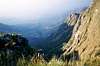
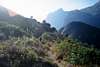
The small town of Mulanje in the south of Malawi is the centre of Malawi’s tea growing industry. The main attraction in the town is Mount Mulanje, a large granite massif. Malawi is a small African nation, situated snugly between southern Tanzania, northeastern Zambia, and Northern Mozambique. Mulanje covers 245 square miles in Malawi's southeastern corner, near Mozambique. The massif rises abruptly from the surrounding plain, and reaches its highest point in Sapitwa Peak. Mulanje has a well organized system of trails and huts, leading through forests of large cedar trees. It is the highest mountain in south-central Africa, one of the world's largest granite inselbergs and has some of the best granite climbing in the world. (Inselbergs are rocky masses that have resisted erosion and stand isolated in an essentially level area). Climbing is to be found on Chambe, Lichenya and Matambale peaks.
Mulanje's peaks, including the highest in the country, Sapitwa, at just over 3000m (9840ft) often jut above the mist that frequently surrounds the upper slopes, giving the mountain one of its local names, 'Island in the Sky.'
The massif is broken up by deep gorges down which rivers with spectacular waterfalls tumble. The mountain rises steeply and suddenly from the undulating plain to the highlands, surrounded by near-vertical cliffs of bare rock, many over 1000m (3280ft) high. Mt. Mulanje was formed from igneous rock, an ancient block that cooled beneath the earth’s surface. Over time, softer rock has eroded away, leaving the isolated granite mass.
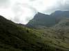
Mount Mulanje ranks among the most majestic sights to behold in Malawi and has an indefinable attraction for climbers and non-climbers alike. From the top of Sapitwa one can view Zomba Mountain and Lake Chilwa. Stunning scenery, easy access, clear paths and well-maintained huts make Mount Mulanje a fine hiking and trekking area. Easy hiking trails can be followed along the valleys and basins, past thundering waterfalls with the towering heights as a dramatic backdrop. You can reach most of the peaks without resorting to technical climbing. The Lichenya Valley is particularly beautiful and has its own alpine-style Lichenya Hut for stopovers.
On its steep slopes stand the unique Mulanje Cedar trees, some of which grow to over 200 years old. The lower reaches are accessible by car and swimming in the cold mountain water is exhilarating. Trout fishing in idyllic surrounding such as these or high on the plateau must be experienced to be believed. (Chambe and Lichenya plateau streams.) Stargazing is so idyllic and the heavens so dazzling on clear nights that it feels like you could clutch stars from the sky.
 |  |  |
Getting There
There is a good road from Blantyre (the M2) via Thyolo to Mulanje township. From the township there is a dirt road from Mulanje to the entrance at Likabula forest station. If using public transport catch a taxi from Blantyre to Limba, then from the Limba taxi rank catch a taxi to Mulanje town. Vehicles to Likabula are harder to find and hitching may be necessary.
Red Tape
Permits must be bought and hut fees paid before climbing the mountain. These change from year to year but are relatively inexpensive (around 20 South African rands a day as at 2003). Porters are available for hire at Likabula forest lodge but are not compulsory as they are in other African countries. A mountain guide is compulsory and costs around 6000Kwacha a day. Guides must be picked from the list of registered guides at the Likabula forest station which rotates their guides on a roster basis. The guide may also be willing to serve as a porter and will often cater for groups if this has been pre-arranged. Guides are given some money in advance for the purchasing of their own food while on the mountain and should be tipped for their services afterwards. They are very knowledgeable and make the mountain experience a far more interesting one.
Note that not all guides are prepared to do Sapitwa peak so if this is your intention check with the guide in advance.
Maps cannot be purchased at Likabula and need to be organised from the surveys office in Blantyre.
Camping
There are 8 mountain huts at various points on the mountain with matresses and fire places and basic cooking facilities. Huts are booked on arrival at Likabula and each hut has a watchman to service the hut. Cooldrinks provided at some of the huts and water and firewood is available. Some guides will provide the food and/or do the cooking at the huts for you but check with them in advance. Tipping the hut watchman is appreciated.
Huts are located at Lichenya, Chambe, Thuchila, Sombani, Chinzama and Madzeka. There is a new hut, Chisepo, at the base of Sapitwa for those wishing to ascend the peak.
Apart from these, there is also a privately owned Forest Lodge near Likhubula Forest Office and a C.C.A.P Hut at Lichenya plateau.
There is a small campsite in the grounds of the Likhubula Forestry Office which visitors are welcome to use, on payment of a small fee.
Camping elsewhere within the Forest Reserve is only allowed at the discretion of the Forestry Officer. Visitors should obtain the Forestry Officer's permission and pay in full prior to camping.
 |
Mountain Conditions
Being typical tropical Africa, the best time to visit is between mid-April and August when it’s dry and temperatures are moderate. November to early April is generally hot and wet while September and October are traditionally hot and dry. If you're thinking of visiting Mt Mulanje, be prepared for sudden downward shifts in temperature, rain and sudden mists at any time of year.
When I climbed the mountains in December/January the weather was characterised by hot days with rain beginning around midday and mist in the afternoons making climbing difficult. Much of the hiking/climbing is on granite and is therefore not suitable for wet conditions.
Note that it is typically much colder on the plateau than at the base of the mountain. Warm gear is necessary at any time of year.
Flora and Fauna
Flora:
The Afro-Montane habitat includes montane grassland and cedar forests. There are 2 types of cedar – the Mulanje cedar (Widdringtonia whytei) which is endemic to Mulanje and another (Widdringtonia nodiflora). Large and small varieties of gladioluses, a colourful array of ground orchids, and proteas also adorn the mountain. Aloes do the upper slopes of the peaks; crysanthenum; wild peach; yellowwood; indigenous forest; alpine meadow and plantation also all occur.
Birdlife
Includes purple-crested loeries, larger raptors, cisticolas and kestrels.
Routes on Mulanje
There is a large network of paths linking the various huts and the route that you choose will depend on your ambitions for your trip. There are three main options - attempting to reach the Sapitwa summit (very weather and season dependent), hiking through the forests, hiking along the mountain plains. Your guide will be able to discuss and plan routes with you. Huts can only be booked upon arrival at Likabula.
Note that the first day of any hike on Mulanje which makes an ascent to the plateau is extremely steep and quite demanding.
 |  |  |  |  |
Emergencies
In the event of an emergency the Forestry Officers at Likhubula are responsible for co-ordinating any search and rescue operations that may be required.
External Links
- Mulanje Mountain Conservation Trust
Support the conservation of the Mountain: An environmental trust funded by the World Bank. Interesting photos and environmental information about Malawi.
- Mark Seuring's account of climbing Mulanje
Read Mark Seuring's account of his trip on Mulanje
hans.schenk - Oct 24, 2007 1:59 pm - Hasn't voted
Interesting Reading"Venture to the Interior" by Laurens Van Der Post is the tale of his attempt to reach the summit of Mount Mulanje, as well as the Nyika Plateau farther north. No matter how you feel about Laurens Van Der Post and his writing, it does help give a bit of a feel of Mount Mulanje.