
|
|
Mountain/Rock |
|---|---|
|
|
39.53138°N / 119.65598°W |
|
|
Washoe |
|
|
Hiking |
|
|
Fall, Winter |
|
|
5954 ft / 1815 m |
|
|
Overview
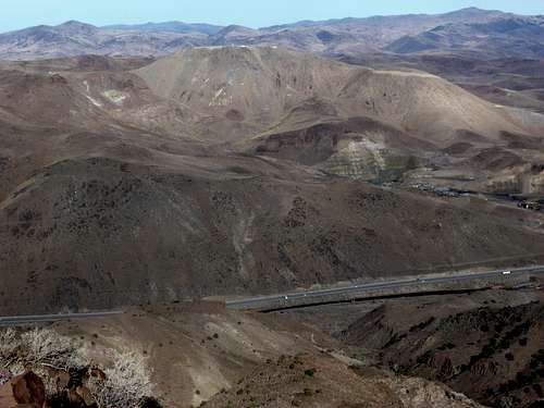 Peak 5954 seen from across I-80
Peak 5954 rises just east of the City of Sparks, Nevada, serving as an Airway Beacon for airplanes heading into Reno-Tahoe International Airport. It is listed as “Airway Beacon” on topographic maps. Its flat-topped summit is home to electric equipment that is maintained by Sierra Pacific Power Company. The summit is not necessarily restricted as there are no signs on the way to the summit that indicate it is off-limits.
 Equipment at the summit
A series of jeep roads leads up to the summit from the west side, starting from a non-descript jeep road off of Vista Blvd in Sparks.
Reaching the summit requires a simple walk, with only the final 300 feet involving very steep walking to reach the summit plateau.
Views from the summit are quite interesting. The Northern Sierra Nevada range is visible to the west, including Freel Peak 10,881’, Snow Valley Peak 9,214’, and Mount Rose 10776’ and other peaks in the Mount Rose Wilderness. The Virginia Range is just to the south with Clark Mountain 7196’ in full view. Tule Peak 8723’ can be seen to the north. A great view of Peavine Peak 8266’ is visible directly west.
Peak 5954 is technically part of the Pah Rah Range, on the extreme southern end. The highest peaks of the Pah Rah Range are in view, including Virginia Peak 8,367 and Pond Peak 8,031’. Spanish Springs Peak 7401’ is seen directly to the north.
Peak 5954 is best hiked in wintertime when temperatures are cooler and the land has dried out. Rattlesnakes may be present on the rocky areas during warm weather months and mud can be a problem during spring time. Bugs are prevalent during other times of the year. No matter when you visit, watch out for Jerusalem crickets, also called potato bugs, which are very large insects that reside in the area. They are not venomous, but they are eye catching and a little bit freaky looking.
It is advisable to hike only after the noon hour. The reason is because the sun shines on the brown hills providing better views and better visibility.
Getting There
The jeep road is located in southeast Sparks and is easily accessible. From Reno take I-80 east to exit 21 (Vista Blvd). Take Vista north for a tenth of a mile and take the first right onto Salomon Ct., where there is currently a Qwik Stop and an insurance company up for lease (as of November 2010). Parking is available on Salomon Ct. right across from the start of the dirt jeep road.For reference, the jeep road starts about a half a mile southeast of the hill with an “S” on it for Sparks. Current internet maps indicate that Horseman's Park is located at the foot of the “S” marked hill off Loop Road and would be an ideal location to start the hike to Peak 5954. However, this is no longer the case, because the land is labeled as “No Trespassing”, even though it is still owned by the City of Sparks. Another road heads south from Loop Road and terminates at a jeep road leading into the hills. However, this too is marked as “No Trespassing”. The only clear entry to the area is from the dirt jeep road described above off of Salomon Ct.
Route Description
The parking area is at about 4490’. A 4WD can continue up the road for a little over ½ mile and find good parking at about 4600’. People drive their 4WD up there to go target shooting, so it is a popular parking spot.Once at the parking area, the road splits and heads to the right. Follow the road as it heads to the right. One road cuts directly up a minor slope, while the other winds around a longer way, but both end up in the same place.
From here, the road curves towards the left and approaches Point 5598; “Rocky” on topographic maps (39.52585, -119.6759).
 Approaching Point 5598
The road switchbacks up the hill and passes Point 5598 on its left side. Point 5598 is a worthwhile side trip, since it is only 250 yards from the road and with about 130 feet of elevation gain.
Once past Point 5598, Peak 5954 comes into view. It is distinctly colored gray rock, different from the light brownish hills surrounding it. The road heads left and eventually ends up at the foot of Peak 5954. A steep 300’ walk reaches the summit.
 Final stretch to the summit
There is a light fence around the summit area, but there are no signs restricting access. Walk through the fence and onto the wide summit area. There is no distinctive summit rock or anything indicating the highest point. Basically, the wide area at the top is all the same height.
It takes about 3 miles and 1500 feet of elevation gain to reach the summit from the parking area.
Approaching from the south or east side of the mountain is not recommended. There is an access road that heads directly up to the summit from the south side from exit 23 off of I-80. Roads off the exit approach the mountain from the south and from the east, both connecting to a main access road to the top. However, these roads go through an industrial area and access issues are likely. The approach from the west side described above is in an area designated for recreation and is the only legitimate way to hike this mountain.