
|
|
Mountain/Rock |
|---|---|
|
|
39.79430°N / 119.47427°W |
|
|
Washoe |
|
|
Hiking |
|
|
Spring, Fall, Winter |
|
|
8247 ft / 2514 m |
|
|
Overview
Pah Rah Mountain is the 2nd highest named summit in the Pah Rah Range, a mountain range that stretches north from Sparks, Nevada to Pyramid Lake. It is not technically its own mountain, given its 225’ of prominence. It is technically a bump on the ridge north of Virginia Peak 8367’, located nearly 3 miles away.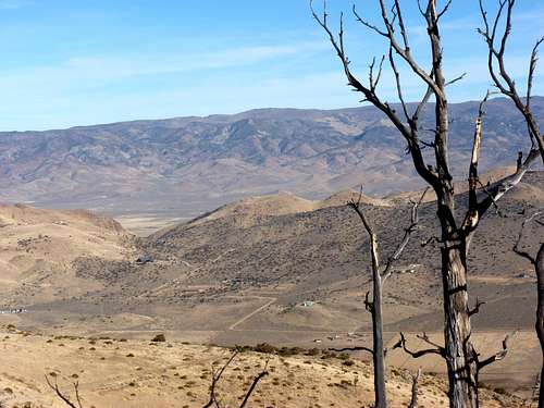
View from the east to Pah Rah Mountain from the Hungry Ridge
Still it is a worthy destination. Located about 37 miles north of Reno, it is not frequently hiked. However, views are tremendous. Nearly all of the giant Pyramid Lake is visible from the summit of Pah Rah Mountain. This is not the case with Virginia Peak, the highest peak in the Pah Rah Range.
Because Pah Rah Mountain is almost 3 miles north up the summit ridge from Virginia Peak, it seems like its own peak. This is also because it anchors the range to the north.
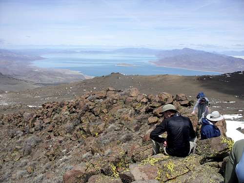
Pyramid Lake from the lower north summit
Pah Rah Mountain can technically be hiked all year round. However, the best time to hike is in the fall, when it is dry – particularly late October through early December. Springtime is good too, but only after a dry week as mud can accumulate otherwise. Rattlesnakes may be present on the rocky areas during the warmest weather months and the heat during summer can be unbearable.
Getting There
From Reno take I-80 east to exit 18 (Pyramid Highway – Highway 445). Follow Pyramid Peak north through Spanish Springs, and continue as the road becomes two-lanes. It is 18 miles from I-80 to the turn off. The turn off is just before the Wild Horse Corral. At the turnoff, follow Ironwood Road, which is a well-graded dirt road, for 4.8 miles to a T junction with Amy Road. Take a right on Amy Road and follow it for about 0.4 miles where the road curves to the left and turns into Wilcox Ranch Road. Follow Wilcox Ranch Road for 2.3 miles and take a left on Quaking Aspen Road. Follow Quaking Aspen Road for 3.3 miles. The road is well-graded dirt, but gets narrow at points. 2WD can easily make it up the road. At 3.3 miles, the road forks left to Microwave Road. Head up Microwave Road for about 3 1/2 miles to the base of Virginia Peak and park at around 7620’ where the road splits and heads up to Virginia Peak. The road isn't too difficult, and a 2WD can make it. However, 4WD high clearance is preferred due to the steepness and the rocks in the road. If taking a 2WD, just be careful at rocky spots. A 4WD can make it 3 1/2 miles up Microwave road in 15 minutes or less, but a 2WD will probably take well over 20 minutes.Primary route
For this route, probably the best course of action is to head up to the summit of Virginia Peak, and then head along the ridge to Pah Rah Mountain. From the road where you park, there are several options to reach Virginia Peak and the main ridge. The road heads up to the summit, but there are also options along the road to cut up the slope straight towards the summit. It is about 750 feet up to the summit in about 1 ¼ miles. Once at the summit, you can see the long ridge heading north in front of you. Continue up the ridge for about 3 miles to the summit of Pah Rah Mountain. Along the way, you will pass an even higher spot - Point 8265 - before dropping down to about 8,000' before heading back up to Pah Rah Mountain.Once at the summit, continue north for a tenth of a mile to a lower bump for the most expansive views of Pyramid Lake.
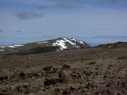
Heading towards Pah Rah Mountain
To descend, head back the way you came for about 2 ½ miles until you reach a mesa top with electrical equipment. Here you will find the north end of the road below Virginia Peak. Head down that road for about 1 mile back to where you parked. In total, the round trip, including the northern most bump is about 8 miles. Elevation gain for both Virginia Peak and Pah Rah Mountain summits one way is about 1100 feet with only a couple hundred feet of gain on the descent.
Red Tape
Pah Rah Mountain is mostly on lands managed by the Bureau of Land Management. As for getting there, as long as Microwave Road is followed, there are no access issues. Quaking Aspen Road also goes up to Virginia Peak from the south, but private land between the road and the peak has a "No Trespassing" sign. Access from the northeast is from the Pyramid Paiute Reservation, and may require a permit from them. However, Microwave Road is the shortest, most straightforward route.Watch for wild horse droppings. They are everywhere. Wild horses are usually seen, but tend to stay away from people.