
|
|
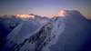
Mountain/Rock |
|---|---|
|
|
61.10000°N / 140.35001°W |
|
|
15557 ft / 4742 m |
|
|
Overview
While I have never climbed or even seen Mt. Slaggard there is a tremendous hole here on Sp with regards to the major peaks of the Canadian St. Elias range... so I have chosen to put up pages for Slaggard and Mt. Lucania with the hopes of getting the ball rolling.Mt. Slaggard which at 4742m is Canada's ninth largest peak...it may also be Canada's least known major peak. Not only is it remote, located about 40km NW of Mt. Lucania, but it is located in the Icefield Range which is subject to some of the worst storms (year round)on earth. Slaggard also simply pales in comparsion to the big 5 (Logan, St.Elias, Lucania, King and Steele) when it comes to its sheer size and the scope of the undertaking. Slaggard isn't as technically demanding, nor is it as impressive when compared to these other big peaks. Slaggard is also even more out of the way than the rest located further north and west, even more buried in the the Icefields than Lucania and Steele.
Mt. Slaggard like all of the major peaks in the Icefield Range is heavily glaciated. Slaggard has three major ridge systems which are split by a T junction.. To the north lies the main summit ridge, to the S lies the South Slaggard 4370m, one of three sub summits and which was first climbed in 1997 by a group of climbers from the Canadians Alpine Association (Toronto Chapter). To the west along a long narrow ridge lies the two sub summits of West Slaggard I 4290m and W. Slaggard II 4210m.
Mt.Slaggard is located within the confines of 22015 km² Kluane National Park and Reserve which was established in 1976. The St. Elias Mountains dominate the park, they are sub divided into two smaller ranges, separated by a narrow trough called the Duke Depression. The Boundary Range lies to the east and is much smaller, the average height of peaks here is between 2000-2500m. To the west lie the major peaks of the mighty Icefield Range which occupies 2/3 of the park. All of Canada’s largest peaks are located in or around Kluane.
The St. Elias Mountains are the second highest coastal mountain range in the world (after the Andes) and is home to many of the continents most massive and imposing peaks. The area is also home to the most notorious weather on the continent as well, with legendary storms regularly blasting the region. Couple this with the mountains remoteness they see very little traffic.
The St. Elias Mountains are a 350km long chain that stretches from NE Alaska, through the Yukon and into NW British Columbia. The St. Elias range surpasses the Himalayas in vertical relief, making these some of the very largest mountains from base to summit on earth. The range is also located closer to a pole than any other major mountain range.
Mt.Slaggard wasn't climbed until 1959 and was one oft he last major summits in the icefields to be scaled. Usually climbers achieve thesummit via Slaggards's eastern ridge. As aresult of Slaggard's unpopularity and it's remoteness climbing Slaggard is a very special experience. It is like having your own private sub range to yourself for the time you are there. The snow is untrodden, and the the whole area is pristine, alpine perfection. For this reason alone are the majority of climbers attracted to Slaggard.
**Photos courtesy of the Alpine Club of Canada Toronto Section.
 |  |  |  |
Getting There
Most trips to Mt. Slaggard are expeditionary in length and start with a flight from Vancouver to Whitehorse and then a 165km trip westwards via the Alaskan Highway to Haines Junction where the park headquarters are located. Trips also operate out of Destruction Bay and Burwash Landing. Like any trip to the inner peaks of the Icefield Range, this is the most difficult and costly part of the trip. To go with a trip operator costs can easily skyrocket up into the $10-15000 range. Even without a trip operator, expect to spend at least $5-6000, it’s a costly undertaking that’s for sure.One company that operates trips to the foot of the major peaks of the Icefield Range is Icefield Discovery out of Whitehorse. They will transport two climbers and their gear (the cost is more per extra climber) via heliocourier on wheelskis. As far as I could see it costs about $750-1000 per person one way. To enquire about prices you can email them at icefield@yukon.net or you can call 1 867 653 2018. These are of course only one of many operators on both sides of the border that offer access to the inner peaks of the Icefields.
From the park reception center at Sheep Mountain it is either a 1-1.5 hour flight to the foot of the Chitna Glacier or it is 2-3 week slog over Glaciers and crevasses. Expect to spend anywhere from four to six weeks in the park if this is the way one chooses to approach Slaggard, and eventually climb the main peak or any of its subpeaks. You will have to carry 30-40kg packs and drag very heavy sledges. It may save a lot of money, but the temporal investment is considerable. The other option one can utilise to try and access Slaggard is via Chitina Alaska. One canflyinto a spot ataround 3540m. The trip is shorter and may beless expensive because of this.
Come prepared for the worst that the St. Elias Mountains can throw at you. Mt. Slaggard is very remote and is very rarely summitted and this is an expeditionary climb, so one must be entirely self sufficient. Rescues do occur, but they are very expensive and the nearest medical evac is hours away.
At this time however there is next to no information available for more in depth descriptions of routes. This mountainis not only isolated and subject to treacherous storms,it is also relatively unknown even amongst the Canadian climbing community. I will try and add more info. at a later date when I get a hold of it.
 |  |  |
Red Tape
The costs of course are the most prohibitive aspect of trying to ckimg Mt. Slaggard. With costs running $5-6000 per person without a trip operator, and with one costs can easily run $10-15000 per person.One must also purchase an annual adult pass which costs $56.00. If you are flying into the foot of the Chitna Glacier there is a $30.00 aircraft landing permit (each way) that must also be paid. The park headquarters are located at Haines Junction. The phone number is 1 867 635 7250 or you can email the office at kluane.info@pc.gc.ca for additional information. There is also an information center located at Kluane Lake called the Sheep Mountain Visitor’s Center.
One must also obtain a mountaineering permit from the mountaineering warden Mountaineering Permit
1. Each member must fill out an application to participate in an Icefield mountaineering expedition and sign the attached waiver.
2. You must include an itinerary which includes: a description of your air carrier, radio communication equipment, arrival and departure dates and a list of the mountaineering equipment you will be bring with you.
3. Each member must demonstrate in the application that each member has the necessary knowledge and equipment for self rescue and to communicate in case of emergency.
You then submit the application as a package to:
Mountaineering Warden
Kluane National Park and Reserve
Box 5495, Haines Junction, Yukon Canada,
Y0B 1L0
Be sure to apply months in advance so that there is plenty of time for the application to be processed. Each member must also view a video on mountaineering in Kluane and register with the park warden at the beginning and end of the expedition.
It is also mandatory that each member must carry either a satellite phone or have a HF radio (single side band communication is recommended) with them at all times for safety purposes. It is also asked that low impact mountaineering practices are observed throughout your stay as the environment is still pretty much pristine.
When To Climb
The weather (even more so than the peaks remoteness) is the reason why Slaggard or any peak intheicefields is rarely climbed. Winter ascents are simply not even attempted. The only real time to even try to climb the Slaggards is from May to September, with the peak period from June 15 to September 15.The mean temperature in July for the park is 14°C, with temperatures in the park ranging from 0°C to 28°C. With that being said it is not at all uncommon for temps to drop down into -20’s or 30’s even at the height of summer.
During the winter the mean temperature in Kluane is -21°C, inhospitable to put it mildly.
Camping
There is only one campground at the park. The Kathleen lake campground has 47 primitive sites. There are also sites just outside the park such as at Kluane Lake. For backcountry users (which all mountaineers are) you make camp at the end of each day, pick stable areas away from the base of mountains and remember that it is critical that each member practices low impact mountaineering.The park is only accessible from May to September, with its peak period lasting in mid June to mid September.
Again it is important to come prepared for violent winter weather with bone chilling cold, that can drop down into the -30’s at any time of year.
One must also understand that the park is home to the largest population of protected grizzly bears on earth. Until you are on the glacier you are in bear country so come prepared.
Mountain Conditions
There are two relatively simple ways to check the weather forecast for the park. The first way is to key in www.theweathernetwork.com on your computer and then checking the parks forecast for Kluane or the forecast for Haines Junction on the Yukon pageOne can also check with Environment Canada by keying in www.weatheroffice.pc.gc.ca or by calling 1-867-668-6061 where you can get reliable up to the hour conditions and long term (5 day) forecasts from park officials.
Kluane National Park
The 22000 km² of Kluane National Park and Reserve was originally set aside in 1976 to protect the large herds of Dall’s sheep which could be found in the area. It was also soon realized the area was home to some of Canada’s most unique and beautiful ecological and geographical features recognized today as a UNESCO world heritage site.The world’s largest non polar icefields are found in Kluane including 65km long Lowell Glacier. In places the ice is up to 1.6km (about 1 mile) thick. The icefields dominate the park covering over two thirds of the park’s territory. With that said though there is still a lot to see in the more popular section of the park.
Kluane Lake is the largest lake in the Yukon, its clear frigid waters are popular amongst fisherman and amongst those seeking a respite from an increasingly frenetic world. Within the Boundary Range most of the parks plants and animals are found. The treeline here is only at about 1100m so many animals stick to the lower slopes and the valleys for cover.
The Alsek River was designated as a Canadians Heritage River just recently and during spring it flows with a force comparable to that of the Amazon River as it roars through icy gorges up to 350m deep.
For over 4500 years Kluane has been the traditional homeland of the Southern Tutchone First nations The name Kluane means ‘lake of many fish’. The natives are involved as co-managers of the reserve and are free to hunt and trap within park boundaries.
 |