
|
|
Mountain/Rock |
|---|---|
|
|
27.1078°S / 109.2346°W |
|
|
1509 ft / 460 m |
|
|
Overview
Two peaks will be covered on this page; Maunga Pukatikei and Rano Raraku. Both of these peaks are on Easter Island, one of the most isolated populated islands in the entire world. It is 1900 kms/1200 miles to the nearest populated place. The island is very small, measuring 12 by 22 kms (7 by 13 miles). The island is known as Isla de la Pascua in the Spanish language and Rapa Nui in the Polynesian language. Rapanui (no spaces) is what the people of the island call themselves.None of the peaks on Easter Island are very high, but all are very, very interesting. There are three main volcanoes that make up the triangular-shaped island (one for each corner), as well as several other sub-peak volcanic cones scattered across the island. The three main peaks are; Maunga Terevaka, Rano Kau, and Maunga Pukatikei.
Maunga Pukatikei is the second highest volcano on the island at about 460 meters/1509 feet. Rano Raraku is really just a cone of Maunga Terevaka, but will also be included here on this page as it is one of the most interesting summits in the world, at least it is archeologically. Rano Raraku is only 260 meters/853 feet high, but is one of the more interesting summits I have visited.
These two peaks have fascinating archeology remains. Maunga Pukatikei is off the beaten track, but has a huge carved head along the route to the summit that no tour groups visit. Since I haven’t found any written information on the peak or its history, I don’t know the significance of it, other than it is very impressive to look at. Rano Raraku is where all the Moai statues that are present around the entire island were carved. All were carved between 690 and 1460 AD. How the people managed to transport and erect the huge statues from the peak and to all around the island remains a mystery, though there are several theories that are often mentioned on tours and in books. There are 400 statues on this volcano, and it’s a fascinating place to visit.
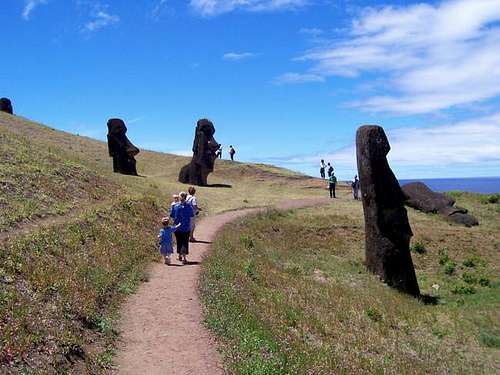 This is a section of the trail below the summit. All statues on the island were carved from slopes of the volcano of Rano Raraku.
History of the Peaks
Easter Island was colonized around AD 300 by Polynesians from Marquesas or Mangareva. The long platforms (ahu) and the statues (moai) constructed at Ahu Akiva, which is at the trailhead for Maunga Terevaka were the last of all the ahu and moai on all of Easter Island and were constructed around 1460 AD. Other statues around the Island were constructed as early as 690 AD. These statues were portraits of known ancestors, were considered "living", and they looked towards a village to protect them.After about 1460 AD, the demise of the culture of the island began in earnest. Since the native peoples had cut down all the native forest, there was no way to escape the island. Over population led to tribal wars and cannabalism. Around 1460, it was thought that about 20,000 people lived on the island. By the time the Europeans (Jacob Roggeveens) arrived in 1722, the population was around 4000. In 1862, a fleet of Peruvian black-birders kidnapped 1400 of the people (known as Rapanui) to work in ght sugar plantations of Peru, and to work on off-shore guano mines. Included were the king and all of the learned class. Missionaries and diplomats in Peru protested, and eventually the 15 survivors were returned, but this set of a small pox epedemic. French Catholic missionaries and Tahiti businessmen contied to remove the native Rapanui starting in 1866. When some were returned to their homeland, they introduced leporsy, and by 1877 the entire native population of Easter Island was reduced to 110 persons.
In 1883 Chile defeated Peru and Bolivia in the Pacific War, and in 1888 Chile annexed the island, thinking it could be used as a port for travel to the Panama Canal. There was no place for a safe harbor, so they leased the island to a British wool operation, which controled the island until 1953. Unfortuantely, during this time period, the Rapanui people were not allowed to leave the capitol town of Hanga Roa. The first Rapanui governor was Sergio Rapu in 1984, and now the Rapanui people once again control most of the island. The current population is about 4500 people, and there is only one town on island, Hanga Roa.
All the Moai statues on Easter Island were carved from Rano Raraku. Some were moved up to 18 kms/11 miles away. How the natives did this is still a mystery, but some theories range from rolling them on logs, walking them with huge ropes, and extra-terrestrial/alien help. Since none of these has been proven conclusively, choose a theory to believe after doing your research.
A total of 397 statues are still at Rano Raraku, and there may still be more that are buried. The statues are at various stages of completion; many are complete, but some are still embedded in the cliffs of the peak and were never finished. Along the main trail described on this page, you will pass 70 standing statues, and 30 lying face down on the ground. The largest of the statues was never finished and remains buried in the cliff. It is 20.6 meters/68 feet long.
Just north of Maunga Pukatikei is Vai A Heva, a huge carved head in the rock. This is on the route described to the summit of the peak. I am not sure when the carving was made, nor its significance since I haven’t found any information on the site, and the tour groups don’t make it out there. Hopefully, the new book I have ordered will explain something about the place.
This is a mountain page, not a history book, so all the above is just a very brief overview. I highly recommend that you read up using several good books on the fascinating history of the island before your trip.
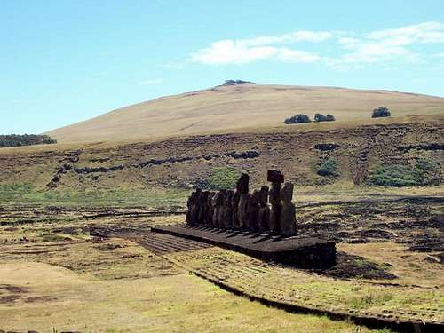
 Rano Raraku from the southwest. The summit of the volcano is in the background.
Getting There
The only way to get to Easter Island is by plane and LAN Airlines. I didn't have much luck trying to book online, but calling LAN is easy. The airline has flights twice a week between Santiago Chile, Easter Island (Hanga Roa), and Papeete Tahiti. The cost varies depending on the time of year, and we paid about $500 in November from Tahiti. Usually it cost about $100 more round trip from Santiago, because the flights are in more demand. Note: If searching online, note that it is cheaper to search and book the flights seperately, such as your city to Santiago (Chile) or Papeete (Tahiti) and then a seperate booking to Easter Island. Interestingly, the runway at Hanga Roa is the second longest in the entire Pacific. The US government expanded the runway in 1986 as an emergency landing spot for the NASA Space Shuttles!Once you are on the island there are several choices for getting around. One is via a tour group and many of these are based in the only town on the island, Hanga Roa. Another way is to walk, but distances are long to some areas. Another way is via mountain bike. A modern high quality mountain bike cost $13 a day to rent in November 2005. If you want some exercise, this is an excellent way to get around, and is highly recommended. Unlike the rest of Polynesia, Easter Island is not unpleasantly hot all year. You can rent a car or take a taxi. Taxis are pretty reasonably priced here. You can also hitch hike. There is no public transportation on the island. Note that the roads on the island aren't posted and don't seem to have names, so they are identified by location (i.e. South Coast).
Maunga Pukatikei via the Northwest Trailhead
From Ahu Tongariki (see above under Rano Raraku), drive, take a taxi, or ride a mountain bike along the paved circle the island road north. Maunga Pukatikei is clearly visible as the volcano forming the eastern part of the island. About half way between the north and south coast, look for a 4wd track heading east. Park at the beginning of the track. This place is about 21-22 kms (13 miles) from Hanga Roa.
 As viewed from Ahu Tongariki (statues) on the South Coast. The summit of M. Pukatikei is above, and is the second highest volcano on the island.
Rano Raraku Loop Route Trailhead
In this case, I highly recommend that you go with a tour group our of Hanga Roa as the guides will know the history well, and will be able to tell you what you are seeing. You still can visit on your own, however. Drive, take a taxi, or ride a mountain bike from Hanga Roa along the South Coast Road. Right near Ahu Tongariki (huge line of statues), is a gravel road heading north to Rano Raraku. A second trailhead is located just east of here and at a place called Ara O Te Moai. There is a picnic/campground here as well. This place is about 18kms/11 miles from Hanga Roa.
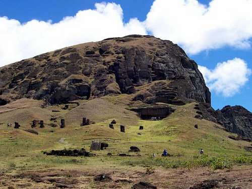 Summit of Rano Raraku from the west. Look close and notice all the carved statues
Routes Overview
Maunga PukatikeiThe route described here will be the Maunga Pukatikei via the Northwest route because this is the route I have taken. The route follows a 4wd track east and northeast to the site of Vai A Heva, which is very interesting. From there, several horse trails can be followed south across the grassy slopes to the summit area. One map I have shows some sort of trail that is more direct and reaches the summit directly from the west. In any case, the entire west side of this peak has gentle slopes and many horse trails, and several routes are possible. The south and east sides of the peak are guarded by high cliffs that drop directly to the ocean.
 You can see Ahu Tongariki (statues) on the South Coast. The summit of M. Pukatikei is to the left, just off the photo and is the second highest volcano on the island
Rano Raraku
Just about everyone uses the Rano Raraku Loop Route to reach the summit. The route starts at the trailhead near Ahu Tongariki and climbs up to the statues and follows the slopes northwest, passing many statues along the way. Once you are at an overlook of the crater lake of Rano Raraku, you simply follow the ridge south to the summit. After returning to the overlook, most people exit the peak via the west and Ara O Te Moai.
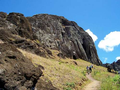
 One of the steeper sections along the trail to the summit of Rano Raraku.
Red Tape
The archeological ruins must not be climbed on or touched. Please do not remove any items from the sites.When To Climb
Anytime is a good time to come to Easter Island. The weather is about as perfect as it gets, at least temperature-wise. When we were there in November, the night were around 20C (68F), and the days were around 24C (74F). It doesn't get much better than that anywhere in the world.It actually rains an average of 140 days at Hanga Roa per year, but since the rocks are so pourous, mud isn't really a problem, and the rain doesn't affect you too much when you are out hiking or climbing.
March to June are usually the rainiest months, and September through December are usually the driest. February is the warmest month, and July to October is usually the coolest time of year. Anytime is still a good time to go, though the high season for tourism is November or December through March, and Easter (of course).
CLICK FOR WEATHER FORECAST
Below are the averages for Hanga Roa:
| Month | High (° F ) | High (° C) | Low (° F ) | Low (° C) | in. Rain | mm Rain | Rain Days |
| Jan | 79 | 26 | 67 | 19 | 2.9 | 74.5 | 15 |
| Feb | 81 | 27 | 67 | 19 | 3.2 | 83.7 | 7 |
| Mar | 79 | 26 | 68 | 20 | 3.8 | 98.9 | 16 |
| Apr | 76 | 24 | 65 | 18 | 5.0 | 130.4 | 15 |
| May | 76 | 24 | 63 | 17 | 5.4 | 141.1 | 12 |
| Jun | 70 | 20 | 61 | 16 | 4.4 | 115.8 | 16 |
| Jul | 70 | 20 | 59 | 15 | 4.3 | 108.1 | 12 |
| Aug | 70 | 20 | 59 | 15 | 3.5 | 90.0 | 9 |
| Sep | 70 | 20 | 59 | 15 | 3.6 | 92.1 | 14 |
| Oct | 72 | 22 | 59 | 15 | 3.4 | 85.0 | 6 |
| Nov | 74 | 23 | 63 | 17 | 2.8 | 72.2 | 9 |
| Dec | 77 | 25 | 65 | 18 | 2.9 | 75.7 | 9 |
 Summit of Rano Raraku from the upper slopes of the peak in November.
Camping
There are campgrounds at Rano Raraku and at Anakena Bay on the north side of the island. Some of the budget guesthouses in Hanga Roa allow camping as well. Chez Cecilia is one place that caters to campers.Note that if staying on Easter Island, there is no need to have a hotel reservation as there are many more rooms than there are flights available to fill them. The hotels that are on travel websites are not as good as value as the homestays. Many of the homestays/guesthouses will meet you at the airport. We paid $50 a night for two children, two adults, breakfast for all, and transport to and from the airport.
Food is expensive on the Island, at least by Chile standards.
Mountain Conditions
CLICK HERE for current conditions and weather forecast for Hanga Roa on Easter Island. Fallen Moai statue just to south of Rano Raraku volcano, which is seen in the background on a sunny day.