
-
 4636 Hits
-
 86.74% Score
-
 23 Votes
|
|
Mountain/Rock |
|---|---|
|
|
41.72595°N / 1.72605°W |
|
|
Hiking, Mountaineering, Scrambling |
|
|
Spring, Summer, Fall, Winter |
|
|
5131 ft / 1564 m |
|
|
Overview
 Peñas de Herrera
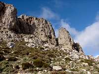
The Peñas de Herrera are one of the best-known images of the nature reserve of the Moncayo, by their pretty silhouette on the town of Talamantes, but nevertheless are scarcely acquaintances among the mountaineers. The mounts situated in the slope of the Moncayo such as Morrón, Horcayuelo or Peñas de Herrera are very little traveled due to that the mountaineer that go about to nature reserve of the Moncayo is always seduced for the nearby peak San Miguel, higher, symbolic and with better panorama.
As many times occurs in SP, is frankly recommendable in this zone to climb first to peak San Miguel/Moncayo if you are for the first time in this area but it's good to know other pretty mountains of the nature reserve if our stay permits us more than one day, in such case, the Peñas de Herrera are a great alternative by their wild and inaccessible aspect from Talamantes, although their western faces (behind in the normal route) are easiest to reach the top.
Another peaks of interest near of the Peñas de Herrera in the natural reserve of Moncayo: La Tonda (1498m), Cerro del Morrón (1731m), Muela de Horcajuelo (1715m), Cabezo del Caíz (1822m).
Trailheads: Talamantes (2h 15min), Purujosa (2h 15min), Añón (3h 15min)
The Four Peaks
Heights: Peak I (1564m), Peak II (1527m), Peak III (1463m) and Peak IV (1320m).Only the second peak, an impressive rocky monolith that simulates a small one Picu Urriellu presents a rock-climb using a chimney of degree II+ for what it need itself a certain experience. The other three peaks can be to climbed in a walk (difficult to believe if only we see the East face).
As curiosity the Peak I is called in some map "Castillo de Herrera" (Herrera's castle) but in old times a castle was located in the summit. Nowadays only the access carved in the rock remember this fact.
Peak I (1564m)
 NE face NE face |
 NE face NE face |
 East face East face |
 Entry Entry |
|---|
Peak II (1527m)
 NE face NE face |
 East face East face |
 SW face SW face |
 Chimney Chimney |
|---|
Peak III (1463m) & Peak IV (1320m)
 Peak III's summit Peak III's summit |
 Peaks I to III Peaks I to III |
 Peak IV Peak IV |
 Peak IV Peak IV |
|---|
Getting There
 Peñas de Herrera
Normal route is generally from Talamantes but the route from Purujosa is as well a good option to climb. The route from Añón it's longer but it's very nice.
Approach to Talamantes:
-From Zaragoza: Road N-232/E-804 to exit Gallur/Magallón/Tarazona in N-122. Across Borja we reach Bulbuente, before to reach Tazaroza, we turn to south to Talamantes.
 Talamantes
-From Pamplona, (also Basque Country or France) : Highway A15 to Tudela (pay) or N121+N232. From Tudela take N121 to Tarazona. From Tarazona take N-122 t Bulbuente and Talamantes as well.
-From Madrid (also center of Spain): it had two options:
a) Take N-I to the north in direction to Burgos. Before Burgos and Aranda de Duero, take direction to N-121 to Burgo de Osma and N-122 to Soria. Follow the N-122 to Agreda and Tarazona, Belbuente and Talamantes.
b) Take N-II/E-90 to Guadalajara and Calatayud. In La Almunia de Doña Godina take C-220 to Epila and Borja. From Borja take N-122 to Bulbuente and Talamantes.
Approach to Purujosa:
-From Borja: 4km at south of Borja in C-220 it's the crossroad to Fuendejal�n. Z-361 to Tierga and Purujosa.
-From Agreda: C-101 to Olvega at south. After 6km at south we turn to Cueva de Agreda, Beratón and Purujosa.
Approach to Añón:
-From Tarazona N-122 to Vera de Moncayo. Z-373 to Añón. In the village of Añón take a forest track to the Central Eléctrica de Morana to park.
Red Tape
The Peñas de Herrera are in a natural reserve with rules about the protection of wildlife.All the routes in the area had wild environments and only a few of persons (when I climbed in December 2006 only 7 persons in all the routes climbing Peñas de Herrera this day). A map is very advisable.
Camping
It's not allowed in the natural reserve. You can to lodge in some of the villages of the area. The most important are Tarazona (Zaragoza) or Tudela (Navarra) in less of 30 minutes of car.External Links
Mendikat, page of the same author with the text in spanish.Muskaria.org page of this mountain group of Tudela with images of the route from Añón across Bco. Horcayuelo (text in spanish).
Diego Sahagún - Aug 29, 2012 10:49 am - Voted 9/10
Firehttp://www.heraldo.es/noticias/aragon/zaragoza_provincia/2012/08/29/desaparecen_humo_las_llamas_del_incendio_calcena_201927_1101025.html (in Spanish)