
-
 4576 Hits
-
 74.92% Score
-
 5 Votes
|
|
Route |
|---|---|
|
|
49.75638°N / 125.52942°W |
|
|
Hiking, Mountaineering |
|
|
Half a day |
|
|
Class 2 |
|
|
Overview
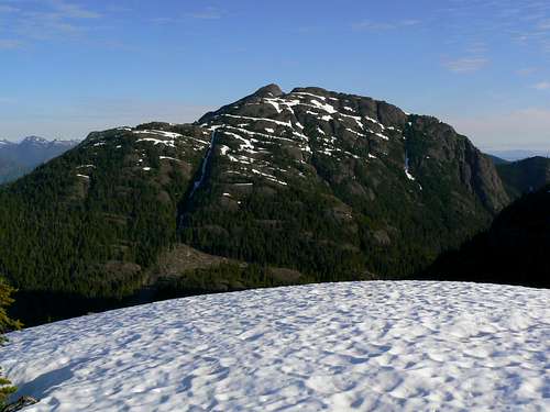 Mt Adrian South Slopes Mt Adrian South Slopes |
From near the high pass between Mt Adrian and Alexandra Peak travels up the south slopes via the communication station there and right over the south summit.
Drops to the col below and then up the obvious left hand (west) ridge to the summit.
Getting There
From Campbell River at the end of the freeway section of Highway 19 take highway 28 west towards Gold River. After 47 km you will enter Strathcona Park at Elk Portal. Exactly 1 km further on highway 28 makes a right turn over the bridge at Buttle Narrows. Ignore the turn and carry straight on down the paved Buttle Lake Parkway (also known as Westmin Mine Road) for ~ 10 km and find “Buttle Bluffs Road” on the left at N49 45.899 W125 35.048 – about 400 metres south of the Lupin Falls day use area.Keeping right and/or uphill at any junctions, drive the steep and narrow road about 7 km southeast and up to the junction of two high hanging valleys with logging roads everywhere. One branch of the valley turns southeast down towards Pearl Lake and the other northeast, up towards the high pass between Alexandra Peak and Mt Adrian from where Alexandra Creek drains the mountains east and down to the Oyster.
Take the left hand fork labelled “Prk 300” and drive the remains of the road as high as you can towards Alexandra and Adrian. From the valley junction on some severe washouts are currently (July 2010) apparent. My 4Runner made it a further ~ 1.5km to 1,200 metres elevation before reaching the limit of its capabilities but we noted that others had made it further.
WARNING
“Buttle Bluffs Road” is not for the faint of heart. Particularly in the upper reaches it’s extremely steep, narrow due to rockfall and is beginning to slough off in places. Don’t try to drive it alone. A “spotter” is essential to guide you through some spots which were just wide enough to get my 4Runner through with the off side wheels on the last few inches of road overhanging the 1,000 metres drop to Buttle Lake below.
Route Description
Drive as high as you can up the left hand fork “Prk 300” of “Buttle Bluffs” road that accesses the two high valleys above Buttle Lake.You’re aiming for a spur road at N49 44.368 W125 31.113 at about 1,300 metres elevation just before the main road reaches its high point.
Depending on the condition of the road and the capability of your vehicle, you may have to walk a little bit.
Turn left and walk or drive the spur right to its end at the usual pile of logging slash. Rough tracks lead through the slash from here where machines have been pulling timber out to the end of the road. Make your way up these tracks aiming for the top left hand corner of the clearing at N49 44.570 W125 31.311. Enter the old growth here.
 Route start Route start |  Brief bush phase Brief bush phase |  Comm station below S summit Comm station below S summit |  Approaching S summit Approaching S summit |
Make your way north through open bush towards the communications facility that you will have seen on the ridge crest on your walk/drive up the upper part of Prk 300. Three series of bluffs bar the way, each one becoming progressively more difficult. The most difficult is the last, right underneath the station. It’s possible to find routes around and up the sides of this bluff on either the east or west – that to the west being preferable.
From the communications station proceed up open rock, heather or snow slopes directly north and right to the top of the south summit. There a few flags and other signs of travel – rudimentary use-path or foliage stripped off krumholtz etc - to follow.
 South summit South summit |  Summit cairn Summit cairn |  Descending from main summit Descending from main summit |  Lower south slopes Lower south slopes |
From the south summit descend northwest down heather ledges to the flat saddle below.
Continue northwest to avoid bluffs on the ridge ahead and find friendly ground on the far side. Turn north as the ground begins to drop towards Rodger’s Ridge to the northwest and continue up to the summit with some minor scrambling.
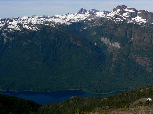
Mt Adrian summit view west
Distance: ~ 8.5 km
Net elevation gain: ~ 650 metres
Total elevation gain: ~ 900 metres
Approximate time: ~ 6 hours return
As always a Garmin/Mapsource tracklog is available for the approach and climbing route on Mt Adrian. Just ask for it via an email or PM.