My two climbing buddies and I embarked on a winter journey of Mt. Mansfield in Winter of 2007
After climbing a few local ranges in Western Massachusetts and Mt. Monadnock, my climbing partners in I decided we were ready to attempt Vermont's highest peak, Mt. Mansfield.
Our trip began in a small central Massachusetts town, "Ware." We all met bright and early as we had a three and half hour + car ride ahead of us. After grabbing a few Dunkin Donuts bagels and Red Bulls, we set the navigation in the Expedition for Mountain Road in Underhill State Park, VT - Some 210 miles away.
The first two hours or so of the drive were pleasant, if not a little dreary. The Green Mountains were shrouded in a misty rain as we headed up Interstate 91. Once we reached White River Junction and I-89, we met old man winter for the first time this season and traffic slowed considerably. Travel proceed at <60 MPH for the remainder of the trip.
After trudging through one-lane traffic, we reached Underhill Center. We drove along a few nice farm roads before arriving at our destination, Mountain Road. At this point, we knew our mountain was directly in front of us, but you'd never know it with the snow falling as hard as it was. The car ascent up Mountain Road to Underhill State Park was fairly treacherous, but nothing 4WD High couldn't handle! We reached the gate for Underhill State Park at about 9:45 and began to suit up. By this time we had 4+ inches of fresh powder to traverse. The outside air temperature at the base was 22 degrees F. The only sign of life was a snowboarder heading solo up the CCC Road for a nice mid-morning descent.
We had a vague idea about how we planned on proceeding up the mountain, but nothing was set in stone. Originally, we had planned on taking the CCC Road Trail up the the ridge and proceeding west to The Chin and descending via the Sunset Ridge Trail.
We started up the CCC Road Trail and soon found ourselves criss-crossing the road on the Eagles Cut Trail. This was a great and unexpected warm-up for us, as none of our maps even listed this trail. The terrain was slightly rocky and the grade was mild.
After reaching the top of the Eagles Cut Trail, we came across a bulletin board with a more in-depth trail map than the one I had purchased the day before. We discussed possible routes amongst the team and finally settled on the following: We would take the CCC Road Trail to the Halfway House Trail and ascend the south side of the mountain to the Ridge. Once we reached the Ridge, we would head North on The Long Trail to the Chin at 4393'. We would then descend either the Laura Cowles Trail or the Sunset Ridge Trail, depending on how we felt at the top.
It wasn't long before we reached the Halfway House Trail, and we were on our way up. The first few hundred feet greeted us with beautiful snowed-covered streams and fantastic rock formations that provided photo opportunity after photo opportunity. It also greeted us with a heck of a grade!! It wasn't long before we were drenched in sweat and short of breath and thinking "what did we get ourselves into!?"
After a period of physical adjustment, things became somewhat easier as we moved forward. We quickly found that our Ice Axes were extremely beneficial to help us get up the 5-10 iced-over rocks that greeted every so often. About halfway up the Halfway House Trail we stopped for a water break and turned around to find that the clouds had broken! We were treated to wonderous views of the valley and further still New York. We couldn't see Lake Champlain, as we had heard we may be able to on a clear day, but were content with what Mother Nature had to offer us on this day.
Next we found a great ice formation which also made for a great photo opportunity. We all pretended to climb the face and took some pictures which made it look like were clinging to the side of an endless icy wall - but don't tell our friends that! They all think we climbed it! (Of course, we didn't - we know our limits!)
The climb was intimidatingly steep for the duration of the trail up to the Ridge. I think, had the vegetation below not been so thick, we probably would have been far less confident climbing this trail. At one point, we lost the trail markers and had to head down 20 or so feet to get back on track. Soon after we were going across an icy rock ledge that was perhaps the most difficult portion of our entire climb.
After coming to the junction of the Canyon Trail, we headed right to the weather station situated on top of the Ridge. The ridge was very exposed to the weather and far, far windier than just a few hundred feet below. We hunkered down behind the building and suited up -crampons, face masks, new gloves - for our final push across the ridge to the Chin.
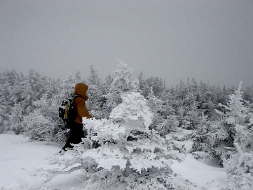
![Traversing the ridge]() Traversing the Ridge!
Traversing the Ridge!
The snow was coming down quite hard all day, and our trip across the ridge via The Long Trail was no exception! There were snow drifts in excess of five feet and most trail markers, trees, and cairns were covered in rime. We managed to locate some tracks which helped us out considerably. Visibility was probably 100 yards and the air temperature was about 5 at this point. Winds were in excess of 35 mph. We made quite a few stops to look off of the ledge on the East part of the mountain which gave us nice views of the trails on Stowe resort. It was a great day for skiers! The mountain was littered with them.
The trek across the ridge was a gradual climb until we came to the base of The Chin, which is a final push of about 150 feet. We were all feeling pretty lethagic at this point, but we had plenty of daylight left to press on. At this point we also found a trail marker for the Sunset Ridge Trail, which we decided would be our descent path.
After a quick little scramble, we were at the Summit! There was nowehere go but down! It was euphoric to stand on the highest point in Vermont. It's a fulfilling and peaceful feeling that you and your buddies are the only people standing on-top at a given moment. The only downer is that we had no view of our surroundings, but that didn't bring us down one bit! We posed for a few group photos and a group photo before quickly descending to the base of the Chin and picking up the Sunset Ridge Trail. Our time to the summit was right at 4:00 hours!
![Mt. Mansfield Summit]() Brr, we made it!
Brr, we made it!
The descent down Sunset Ridge was very well marked with Cairns. The terrain near the top was rocky and covered in Pine Trees. We were literally walking through a pristine winter wonderland.
Soon, we got a big surprise when the clouds and snow started to break and got a chance to look across the valley and back at the south side of the mountain that we had just climbed. We all looked at each other and said "did we just do that?!" The mountain looked very steep from that vantage point. After snapping a few more photos, we ran into a gentleman on his way down. He had reached a slippery portion of the trail which he could not ascend without crampons. It was a good decision on his part, as crampons were essential on this day.
The descent down Sunset Ridge was relentlessly long, but worth every step as the terrain was beautiful. There were also quite a few wooden bridges which made for nice views and easy trekking. We stopped quickly at a small bench near the junction of the Cantilever Rock Trail for some trail-mix and a swig of water. I learned afterwards that the Cantilever Rock is a balanced slab of rock that is a big attraction that we missed on the mountain. Hopefull we'll see it next time!
We continued on and reached the bulletin board which we had begun at. We pulled our crampons off, took another swig of water, and continued down the CCC road to the car. Again, we picked up the Eagles Cut Trail which makes things a bit shorter. We also caught a glimpse of a few skiers gliding down the road, which was cool.
Finally, after 6:15 minutes of nearly non-stop climbing and descending, the Expedition was in sight! Phew! We stripped down to our base layers, posed for a few quick pictures, and we were on our way back to the Bay State.
At the bottom of Mountain Road, I glanced in my rear-view mirror and saw that the mountain had become totally exposed!! We could see what we had just done for the first time! We all agreed that it was essential to stop and pose for pictures with the prize. What a payoff!
On the ride home, we discussed the whole trip. We were all ecstatic with how well prepared we had been for the day. If we didn't have crampons and and ice axe, we wouldn't have made it up the mountain!! Like they say, preparation is everything.
So thank you Mt. Mansfield for a wonderful day. You provided my friends and I with a memory that we won't soon forget. I recommend this mountain to any enthusiastic climber during any season. Just remember to come prepared, and to come in shape!! Cheers!!!! Here we come White Mountains!!

Comments
Post a Comment