
|
|
Route |
|---|---|
|
|
41.20036°N / 111.88236°W |
|
|
Hiking |
|
|
Spring, Summer, Fall, Winter |
|
|
Most of a day |
|
|
Mostly Hiking |
|
|
Overview

Route Map

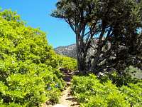
Thick Forest along Beus Canyon
One of the three most popular routes attempting Mt. Ogden is from the west via Beus Canyon. This non-technical route is 6.5 miles from Beus Trailhead on 46th Street in Ogden to the top of Mt Ogden. The route is mostly YDS Class 1 and 2 hiking but can go up to Class 4 depending on how you decide to scale the hillside from the trail to the Ogden Saddle. Slower hikers require 9+ hours roundtrip while hardcore, fast hikers have recorded doing it in 4-5 hours.
The route is part of the Great Western Trail System and continues down the Snowbasin (east side) of the mountain and north toward Ben Lomond/Willard peaks (~10 miles to the north).
During winter and spring, you can expect most of the trail to be covered in snow. Snow patches on the upper trail/traverse may be present from October into July.
In the spring, you have to ford the creek 4 times and it may be swollen with snowmelt. The creek isn't very wide (jumpable in most places) but it may require some minor wading. The lower trail also gets a couple of small mud quagmires in the fern fields during the spring.
During the summer, the lower trail is well shady but humid. The traverse and above are exposed and west facing.
Route Description
Scale the steep hillside if you miss the trail

Helipad on top of Mt Ogden
Trail along mountainside

The Fern Fields
The hike to the top can be broken into 4 segments
Beus Trailhead thru Fern Fields (Approx 2.5 Miles)
Along Mountainside to Traverse (Approx 2.7 Miles)
Traverse to Saddle (Approx 1 Mile)
Saddle to Mt Ogden (Approx .4 Miles)
Segment 1: Beus Trailhead thru Fern Fields (Approx 2.5 Miles)
Starting at the 46th Street Trailhead, the trail is well maintained YDS Class 1 hiking and follows Beus Creek up through the canyon. At about 2 miles, you will reach the fern fields. Continue through them for about ½ mile. The ferns get incredibly thick during the summer and may require a machete to help chop through the trail.
As you are nearing the end of the canyon, pay attention for a right turn crossing the creek. It may be difficult to see as it looks like a spur as the trail continues up the canyon.
Segment 2: Along Mountainside to Traverse (Approx 2.7 Miles)
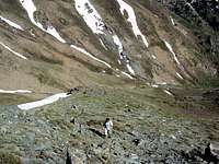
After you cross the creek, the trail goes south up the side of the hill. The trail turns generally east and follows the mountainside through the forest. The trail is YDS Class 1 during this portion and not especially steep. After about 2.3 miles the trail does a dog-leg and goes west up the hill to the traverse. It gets kind of steep (steady, not crazy) as you are gaining vertical. During the winter and spring, the dog leg may be covered with snow and difficult to see. In the event you are certain you missed the turn and/or you don't feel like fighting the snow, take your best guess and go straight up the rocky hillside to the traverse (YDS Class 2/3/4...you'll be sweating and swearing the whole way!).
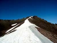
Segment 3: Traverse to Saddle (Approx 1 Mile)
Once on the traverse, you'll see Mt Ogden to the North and it looks incredibly close. Don't be deceived, you still have over a mile to go. The route going east is marked by Cairns (Finding the route back down the hillside is much easier as you can spot the faint trail during your descent). Follow the traverse to the Mt Ogden Saddle.
Segment 4: Saddle to Mt Ogden. (Approx .4 Miles)
The trail from this point is still obvious as you can see Mt Ogden to the north. Follow the ridgeline trail to the dirt road, climb the steep dirt road, follow the marked path to the Top and you are there. The last .1 up Mount Ogden is via one of the steepest vehicle roads I've ever been on--look for the marked trail to get to the helipad. On the top/ridgeline DeMoisy and Strawberry peaks will be to the south and Snowbasin ski resort to the east. You can also look down 2000 feet and see Malin Basin/Peak to the west.
Hazards
Overall, there are only minor hazards on the route. The trail is pretty well defined, limited climbing is required and the bugs are negligible and of the non-biting variety. Much of the trail is on west facing slopes so it does get hot and does get a lot of direct sun. Don't get fooled by the cool canyon portion in the first part of the hike. Both DEET and sunscreen are highly recommended.
The major hazards for the Beus to Mt Ogden route are water, terrain and fauna.
Water can be a serious limiting factor as there are no resupply points after the fern fields. This pushes you to two options. You can A: Not drink or B: Carry a heavy pack. Personally, I go through a gallon+ of water on a hot day on this route but I do see people who lighten up for speed and carry significantly less.
There are several terrain issues even though it is a well-defined trail. First, the trail has rocky portions that can turn an ankle. Cell phone service is iffy in the canyon portion, so broken body parts may require a lonely wait for rescue. Secondly, the trail is kind of overgrown in places with leg-shredding Gambel Oak. Long pants are advised.
The is a large rattlesnake population on the route. Keep your eyes open and watch out! They seem to like to hang out in/near the marker cairns on the traverse so be careful when taking a break.
Finally, this is a 13 mile round trip with 4400 gain. Casual hikers can take upwards of 10 hours to complete the climb/descent so plan accordingly. Late starts and poor planning can leave you waterless, exhausted and finding your way through a dark forest.
Getting There
The Traverse
From I-15, take exit 341 toward 31st St; follow signs for Weber State University. After 1.2 miles merge onto UT-79 E/31st St. Turn right at US-89 S/S Washington Blvd. Turn left at 40th St. Continue onto Country Hills Dr. Turn right at S 1200 E St/Harrison Blvd. Turn left at E 4600 S. E 4600 S turns slightly right and becomes S 1900 E. Destination will be on the left.
In general, you head toward Weber State, get on Harrison Blvd, head south until you reach 4600, turn east toward the mountain, Beus Trailhead is at the top of 4600.
Essential Gear
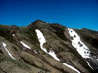
DeMoisy and Strawberry are nearby
Most of the year, you should only need standard hiking gear. Snowshoes are near mandatory in the winter and/or some of the steep trails may require crampons.
Water is mostly unavailable after crossing the creek; recommend at carrying at least 2 quarts during the summer.
Bring sunscreen--the West facing slope gets lots of sunshine!
Websites
http://www.utahtravelcenter.com/activities/hiking/hiking-trailsnorth/mountogden.htm
http://www.weberpathways.org/trails_display.asp?ID=19&search=yes&searchField=bikeOnly&searchText=
http://www.localhikes.com/Hikes/Mt_Ogden_7160.asp
http://www.ogden-ut.com/hiking.html
http://www.trails.com/tcatalog_trail.aspx?trailid=HGS320-004
Flora and Fauna
The Beus trail toward Mt Ogden is the “Tour-de-Utah” of ecosystems. It starts in a Gambel Oak/Canyon Maple forest, graduates into Aspen, changes again to a huge Jurassic Fern Field. Once heading up the mountainside, it’s again Gambel Oak and finally alpine grass/sage. You’ll also note small cacti and wildflowers.
Animal life consists of moose, wild turkey, grouse, deer, elk, rabbits, bobcat and fox. You’ll also see a lot of songbirds along the way if you go in the summer. Rattlesnakes are very common along the route, so exercise caution. There doesn’t seem to be too much of a mosquito problem but DEET always comes in handy.
Camping and Red Tape
Camping is allowed but, once out of the canyon, few spots are desirable for even primitive camps. The trail is narrow and ground rough. I highly suspect very many people have even bothered as I didn’t see any fire rings.
Red Tape:
USFS land, no fees. Dogs/horses are allowed. No Motor vehicles. Mountain Biking is allowed, but not recommended above the 1st bridge (1/2 mile).
Being USFS land, be sure to abide by the usual regulations inherent to
Government property.