
-
 19812 Hits
-
 73.06% Score
-
 3 Votes
|
|
Route |
|---|---|
|
|
53.39000°N / 9.49°W |
|
|
Hike |
|
|
Most of a day |
|
|
Walk-up, steep in some places |
|
|
Approach
See getting there. Leave the car park at Lough Doo and head south for 600m or so. There is a rough bridge at the south tip of the lough. Cross it, then head south for a bit. Turn right then head up the spur or gully of your choosing. There can be some gentle scrambling up a rocky and grassy face, or if you head south for 15 minutes, your climb will amount to a grassy ramp.Route Description
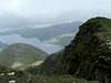
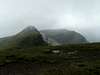
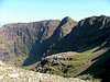
Total distance covered is about 17 km, with around 1100m of total ascent. This is simply one of the best walks in Ireland.After starting your ascent up the east face of the massif, a grassy ramp will appear at about 420 metres. Follow the ramp east, and go up a steep spur to about 760m. From here, the route is obvious on a clear day. First, head SW over some rocky terrain to the East Top of Ben Lugmore. The route turns NW, and you'll go over some ridges and through some minor cols. This will also be your first view of Mweelrea itself. Be careful in bad weather, a fall off the north cliffs would be less than ideal. Over the course of the ridge you'll summit Ben Lugmore and its west top. Come down the ridge, then turn slightly right towards the cairn on Ben Bury.
After hitting Ben Bury, go SW towards Mweelrea itself. Descend to a somewhat boggy col at 650m, and stop to enjoy the views of the Atlantic and the ridge you just traversed. Head due south towards Mweelrea up a steep slope. At the end of the slope, turn right. The hill leads you left, but avoid this as you'll end up down a very steep slope and miss Mweelrea. Take this spur around to head south again. The summit isn't marked at all. Keep heading south to a point where further descent is possible only by mountain sheep. Turn left, heading east, take in the valley, and start your 5km walk back to the road. I personally recommend avoiding the boggy summits of 495m and 379m, keeping left (north) of them. Keep heading west until you see a fence. Follow this past a forest, and keep on trucking until you hit the Delphi adventure centre. Head north on the road back to your car (about a 30 minute walk). The circuit can take 5.5-7 hours to complete.
 |  |  |  |