

PAROFES - Nov 27, 2013 9:43 am - Voted 10/10
A fantastic...collection of good photography and data base.
Great job Silvia!
;)

Silvia Mazzani - Nov 27, 2013 11:52 am - Hasn't voted
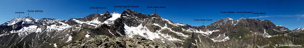
Re: A fantastic...Many thanks, Paulo! I wish to add slowly some other alpine outlines, the job is to recognize the summits without mistakes...
All the best to you!
Silvia

rgg - Dec 21, 2013 12:50 pm - Voted 10/10
Re: A fantastic...A few years ago, in the forum, I read a post how to find mountains names on a photo. Ever since, I've been using Ulrich Deuschle's site to figure out the peaks in my pictures. Very useful!
Silvia Mazzani - Dec 22, 2013 11:29 am - Hasn't voted
Re: A fantastic...Ciao Rob,
thanks, i have taken a quick look to the site! Very helpful. But if i have well understood, it can be useful only about the area inside the red triangle. Or not?
All the best.
Silvia
rgg - Dec 22, 2013 3:24 pm - Voted 10/10
Re: A fantastic...Oh no, there are no such limitations. You can move to any location, and generate a panorama from there looking in any direction and as wide as you like, even 360 degrees.
For the location, there are several ways to select that. The two that I use most are to move around on the map (zooming in and out in the process) or, if I happen to know them, to enter the longitude and latitude directly in the form below. For the direction and width, there are several methods to select that as well.
I just discovered that the site is multilingual not just in German. You can switch to Italian, and then it should all make sense.

hiltrud.liu - Jan 29, 2017 10:58 am - Voted 10/10
Fantastic...Fantastic! Thank you for submitting your pictures to Summitpost, and not only on your own homepage. Greetings, Hiltrud
Silvia Mazzani - Jan 30, 2017 12:19 pm - Hasn't voted
Re: Fantastic...Thanks Hiltrud, i'm happy you like my pictures!
Greetings, Silvia

livioz - Jan 25, 2019 12:30 pm - Voted 10/10
Just......a great and useful work, Silvia!
Silvia Mazzani - Feb 4, 2019 6:51 am - Hasn't voted
Re: Just...Thank you, Livio!
Comments
Post a Comment