
|
|
Route |
|---|---|
|
|
42.83293°N / 0.11381°E |
|
|
Download GPX » View Route on Map |
|
|
Hiking, Mountaineering, Trad Climbing, Sport Climbing, Mixed, Scrambling |
|
|
Summer, Fall |
|
|
Most of a day |
|
|
Class 4 |
|
|
level 4, french scale |
|
|
IV |
|
|
Overview
 Last length
 The ridge
 The ridge
If you ask some local mountaineering folks of the Pyrenees what are the most popular rock-climbing routes in the whole range, both easy and breathtaking, for sure this one will be amongst the answers, and perhaps as a first answer (on granite, for sure as first).
The Trois Conseillers route takes its name from the eponym peak, which links to this route via the saddle "Brèche du Néouvielle". But, instead of climbing the Peak of Trois Conseillers, the Trois Conseillers route goes to the top of the undisputed king of the area, the Pic de Néouvielle, via the East ridge.
The "Arête des Trois Conseillers", as seen from anywhere else is an extremely thin ridge, with vertiginous precipices left and right. However, the ridge is never too narrow, neither presents any problematic step during all the length, elevating gradually till the end. The rock, a tough and grippy granite, is excellent. The goal, Néouvielle, is one of the most magnificent three-thousanders of the Pyrénées (let's add: well served by roads till 2000m). Finally, the background and panoramic views during the climb, with all the splendid lakes of the massif in sight, are simply astonishing. All together, these are certainly the reasons why the "Trois Conseillers" is a classic one.
Unfortunately, this popularity, especially during the nice week ends of the high season, brings misfortune to those who don't wake up early enough. The route tends to be crowded and parties messing with their respective ropes. However, "crowded" is a very relative word in the Pyrenees, and the one who will avoid such moments will savour it in perfect serenity.
Note : the surprising name of "Trois Conseillers" comes from a story (or legend, no one knows anymore) about three chamois hunters who used to argue about hunting grounds long time ago, and who made a council on that peak so solve the contentious.
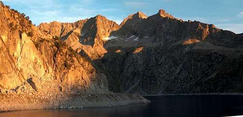 Sunrise from the south side. The ridge is well seen in the middle
Getting There
 Pic de Néouvielle
 Pic de Néouvielle
 Lac Bleu
 Refuge de la Glère
 Néouvielle & ridge from Cap de Long
 Néouvielle & ridge from La Glère
There are two possible trailheads to get to the start of the route.
One of them is the classic starting point of the Néouvielle area, the car park of Lac d'Aubert (more reasonnably, park at Lac d'Orédon for free and take the Laquettes path).
The second one is from the hut Refuge de la Glère, best reached from Barèges.
Despite being close to each other, they are reached from two distinct and distant valleys: Vallée d'Aure for the first, and Vallée de Bagnères for the second. Each can be reached from the A64 french motorway, respectively from the Lannemezan exit and the Tarbes/Lourdes exit.
From Spain, only the Aure valley is reacheable via the tunnel so the Spanish are more likely to use the classic starting point.
View Larger Map
Route Description
 On the ridge
 On the ridge
 Néouvielle normal route
 Boulders field
 Brèche de Chaussenque
 Brèche de Chaussenque
 Br. Chaussenque, other side
 Brèche de Néouvielle
The rock-climbing part, as described before, starts at the Brèche de Néouvielle and lasts until the top of the Pic de Néouvielle.
The only spot which might cause problems on the way is called the "letterbox" ("la boîte aux lettres"), an exposed and narrow dihedral (photo). People use to say that the average level of the climb is 3 (french scale), and reaches 4 only at this spot.
The final part presents a last vertical drop over what is called the "sculpted wall", the final part to the top, but as its name says, it is full of friendly fissures, almost a game (photo).
As for the rest of the trip, two possibilities of reaching the pass Brèche de Néouvielle exist.
The most common route starts at the Aubert (or Orédon) car park. The beginning is identical as if we wanted to climb Pic de Néouvielle but instead, we cross the Brèche de Chaussenque, a large high saddle, to get on the other side of the mountain. Behind is a large wild valley made of huge instable granite boulders, overlooking a crowd of little glaciar lakes below (Lac Bleu, Lacs Verts, etc). Without going down till their level, we go steadily across the slope, keeping as high as it is comfortable to walk, until we have the Brèche de Néouvielle in sight, and to which we finally climb. On the Brèche de Néouvielle, we suddenly get a splendid view of lake Cap de Long on the other side.
The return, after the top, is made via the normal route of the Néouvielle.
The other route consists in starting from the hut Refuge de la Glère, and getting to the Brèche de Néouvielle, and is very similar to the route going to the Turon de Néouvielle. Instead, over Lac Bleu, we head to the Brèche de Néouvielle. It has the advantage to be earlier in the morning on the ridge, but only if we sleep at the hut, not if we start from the road. we must also beware that this gain of time is compensated by the fact that once the route is finished, a longer return is waiting, starting the descent via the normal route of the Néouvielle, but turning left to the Brèche de Chaussenque.
Both routes totalize about 11-12h in total, depending on the speed. Everyone must be aware that a very early start is required.
 On the ridge On the ridge |
 On the ridge On the ridge |
 On the ridge On the ridge |
 Final push Final push |
Essential Gear
 Hiking gear needed
 No escape !
As mentionned, this is not only a rock-climbing route but also a mountaineering trip involving a significant hike. We must have all the essential gear: good boots, gaiters (the snow can be deep and melting), clothes, food, water... Hiking sticks can be welcome in the big rocky chaos, like the ones preceding the Brèche de Chaussenque and the Brèche du Néouvielle, in which we can progress only slowly and with care.
As for rock-climbing, a standard rope of 50-60m, harnesses and the usual rock-climbing gear is the standard for parties of 2-3 people. Some local folks do this route without them, but it is not adviseable. It can be done easily with the walking boots, but it is not a bad idea to bring along rock-climbing shoes, in which some people might feel, while the real boots stay in the rucksack till the top. The route is not equiped with any man-made features, all belays are made around prominent stones abunding all the way long.
Red tape
 Misty ascent
 Misty ascent
Never undertake this trip with the smallest risk of weather turning stormy !
The ridge is a terrible exposed trap with no way out. Storms do start very quickly in the Pyrenees, and this traverse involves at least a couple of hours for the quickests.
External Links
There is an interesting blog page about the climb :http://pyreneen65.blogspot.com/2009/07/neouvielle-3092m-le-31.html