
-
 4933 Hits
-
 78.27% Score
-
 9 Votes
|
|
Route |
|---|---|
|
|
37.84592°N / 119.44284°W |
|
|
Trad Climbing |
|
|
Spring, Summer, Fall |
|
|
Less than two hours |
|
|
5.10a (YDS) |
|
|
10a |
|
|
5 |
|
|
II |
|
|
Overview
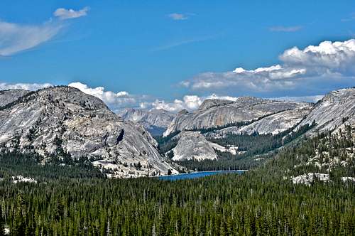 Pywiack Dome, 400 feet, can be seen as a small formation in the middle of the photo and just beyond Tenaya Lake
Needle Spoon is the name of a route on Pywiack Dome in the Tuolumne Meadows area of Yosemite National Park in the Sierra Nevada Range, California.
Aside from its extremely popular neighbor "Dike Route," Needle Spoon is another Tuolumne mega classic. During the hot summer months when Yosemite climbers escape to the altitude for cooler weather, climbing on Pywiack Dome turns into a spectator sport. You often see the tourists stop to checkout climbers crawling up this beautiful dome like ants. If you have done any leading of a climb in Tuolumne, you know very well that you forget about everything else including the spectators.
Needle Spoon, like most Tuolumne slab routes is terrifyingly run-out, meaning that the distance between bolts may be a bit too great for comfort. In a strange way, this may be a good thing in that it forces you to stay well within your ability level. In short, you cannot dog your way to the top of this route.
Needle Spoon
 Pywiack Dome
 My wife taking a dip in the cold Tenaya Lake water
Note: Since I took the direct approach to the base of official first pitch, I have decided to call the approach pitch as pitch 1. Most climbers, however, approach the route using the low angle ledges to the left of the direct start.
Approach Pitch/Pitch 1: Climb the gradually steepening slab, as shown in the topo, to a fairly good ledge. This is the direct start to the route and it's an exercise in steady nerves and extreme caution. Looking at this pitch from the bottom, the rock looks friendly enough, but fifty feet up when the rock is becoming steep with NO protection below you, you wonder if this approach was a wise decision. Luckily, there was a 1/4" bolt about ten feet from the top of the pitch.
Pitch 2: Climb a runout 5.7 slab to the first bolt. Shortly after the first bolt go left and up, about 5.9ish, then right again to a line of few more bolts to the first double-bolt anchor.
Pitch 3: Crux pitch- climb up and left to a bulge protected by a bolt. Surmount this crux section, 10a, to a beautiful 5.8 slab to another two-blot anchor.
Note: After the crux, the 5.8 face is terribly runout. You can see a bolt far up and right on the skyline for your next protection. The anchor at the end of this pitch is shared with "Dike Route." Fortunately, the team climbing Dike Route got to this anchor after we had vacated it to the next anchor. At the end of pitch 4, we joined forces with the Dike Route team tying our two ropes together and rappelled to the base with two raps.
Pitch 4: Easy with absolutely no protection for the entire pitch. Most climbers rappel down from the top of this pitch.
Pitch 5: To reach the very top of the dome traverse right to the base of a wide crack and climb to the top.
To descend from the very top find an anchor near the east face and rappel about forty feet and work your way back to the base. Most climbers, however, rappel the route starting from the top of the fourth pitch.
Essential Equipment: 2 sixty meter ropes, ten quick draws, and if you are going to the very top, bring several large cams and plenty of slings to reduce friction.
How to get there
From the east:From Highway 395 take Highway 120, Tioga Pass Road, for about fourteen miles to the east entrance to Yosemite National Park. From the gate drive past Lembert Dome to your right and, shortly after, Tuolumne Store on your left. From the store, drive another seven miles on Highway 120. You will see Pywiack Dome on your left and across the creek from the road. There is a wide and long dirt shoulder that you can park on. If you go as far as Tenaya Lake, you have gone too far.
From the west:
Coming from the west, which is the direction of Yosemite Valley, go past Olmsted Point, a popular viewing point, and past Tenaya Lake. Shortly after the lake you will see Pywiack Dome on your right and across the creek from the road.
Camping
 North Peak seen from the Loop Trail
There are many campgrounds in the Tuolumne Meadows and Tioga Pass area. During the peak season, however, it’s possible that you end up driving from campground to campground looking for a campsite to no avail. It’s important to remember that you can always camp close to Tuolumne Meadows without being in the heart of it. There are a number of campgrounds along Highway 120, Tioga Pass Road, that can be used. There are also a number of camgrounds along Highway 395 and in the Mammoth Lakes area. It’s always a good idea to plan ahead and the following links should help a little.
Tuolumne Meadows Camping
Saddle Bag Campground
The Sierra Web/Camping
Mono Lake Station- 760-647-3000
Rush Creek, Mammoth Lakes Station- 760-924-5500