Preview and Preparation
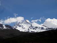
![North Side of Solimana]() North Side of Solimana
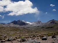
North Side of Solimana![Approach to Solimana]() The Approach to Solimana
The Approach to Solimana![Looking for an Approach Road]() Looking for a Road to Solimana
Looking for a Road to SolimanaWhen we finished climbing Nevado Coropuna about 1½ years ago, we drove from our base camp at the foot of Coropuna to Cotahuasi. As we drove away from Coropuna, we couldn't stop looking back at where we had just been, on the top of Coropuna. We kept taking pictures and talking about our climb, until we came into sight of Nevado Solimana in front of us. Now our thoughts and conversation turned to climbing Solimana in the future. Solimana isn't as high as Coropuna, but it is much harder as it is a technical climb, where Coropuna is non-technical and didn't require any special skill. Therefore I was not really sure that I would be able to climb it, as I had never done any technical climbing in snow or ice. I had done quite a bit of rock climbing, but hadn't advanced to a very high level, only 5.10 on a good day, and that was about five years ago.
The following year I returned to the United States to hike the Pacific Crest Trail from Mexico to Canada. I was a bit worried about being able to do the whole thing, because the whole way through the Sierras, the trail goes over snow covered passes. I bought crampons and borrowed an ice axe, but didn't get a chance to practice with them before the hike. I figured that when we got to the first snow covered slope, I would be able to practice, but there was really no opportunity to on the way up Forester, our first pass. When we got to the top and started down the other side, we were faced with lots of snow on a steep slope, and it was too dangerous to practice there. I never did get to practice self-arrest, but did carry the ice axe through the Sierras, and fortunately never needed to use it in an emergency. I lost my crampons a few days later, having never used them either.
Before returning to Peru, I bought an ice axe and new crampons, knowing that I would need them for Solimana. I had been in touch with Carlos and Hugo, my climbing friends that I did Coropuna with, and we made plans to climb Solimana shortly after I returned. After a few changes in the schedule, we finally had firm plans to make the climb on November 11th. I had already returned to Cotahuasi, and Carlos and Hugo would be coming from Lima. They were to be going to Coropuna on the Reyna bus, and I was to meet them at Visca Grande, the closest place on the road to the base of Solimana, at about 2:30 am. I wasn't sure exactly where Visca Grande was, so I left Cotahuasi early to give me time to find it, as well as to find a way to drive as close as possible to the start of our climb. We had basic directions from a trip report on Summit Post, as well as a copy of a topo map of the area.
Meeting my Friends, Getting Ready to Climb
![Visca Grande Camp]() Visca Grande Camp
Visca Grande Camp![Vic, Carlos and Hugo]() Vic, Carlos and Hugo
Vic, Carlos and HugoI tried numerous routes to the mountain from the main road, but was not able to get very close. There was another road going to a village on the high plain, and it looked like that would get us closer, but I didn't have time to check that out before dark. I did find where Visca Grande was, so parked along the road there, and waited for the bus. I had about six hours to wait, so set my alarm and tried to get some sleep. I set my alarm plenty early, to make sure I was awake before the bus arrived. I finally saw lights coming on the road towards me, but it turned out to be the Alex bus. A little while later were more lights and that was Reyna. I flashed my headlights at the bus, and they stopped and my friends got off. I told them what I had found out, and we agreed to wait there until morning; so Carlos and Hugo set up their tent and I slept in the back of my station wagon.
In the morning, we drove towards Cotahuasi to the intersection of the other road, and then started driving back towards Solimana. The road curves a lot, so for awhile it looked like we were as close as we could get, but we went a little farther, and after going around a curve, we started getting closer to the mountain again. We soon saw the small Soro River, that the report had said was the landmark to follow as the approach route. We parked the car and started to prepare our gear for the hike. It is very remote area, off the main road, so it seemed like a safe place to leave the car for two days.
Carlos and Hugo are both members of Camycam, A Lima based mountain climbing club, and both had experience in snow and ice climbing in the Huaraz area. They were also carrying all of the technical climbing gear; all I had was my crampons and a regular ice axe, in addition to trekking poles. I offered to carry more of the gear; they did give me a snow anchor.
You can read Carlos' report in Spanish hereThe Hike to Base Camp
![The Ridge Approach]() The Ridge Approach
The Ridge Approach![The Easy Part]() The Easy Part
The Easy PartAt 11:05 we were ready to start the hike up the streambed to our base camp. We were able to see our goal in the distance, and it didn't seem that far away. It is a very easy hike at first, not very steep and there were many cattle and llama paths to follow. However, we did start the hike at close to 14,000 feet, so we were all feeling the affects of the altitude. Both Carlos and Hugo live in Lima at near sea level, and I had only been back in Cotahuasi for less than a week. I had spent a few days in Huaraz just before that, with a hike down from the base of Huascaran, so was a little better off than they were. Unfortunately it had been over a month since I had finished the PCT, and in spite of having done some hiking right after that, the last few weeks had been spent visiting and eating, with friends and relatives, and I could feel my conditioning had started to fade. My lighter pack and relatively good shape more than made up for my age though, and I was able to lead the hike up to where the terrain got steeper.
We were making slow but steady progress, and stopped for lunch at a large boulder where we surveyed the climb ahead of us. After a nice break, I again led the way up the broad ridge, hoping to get as close as possible to the glacier to set up our base camp. I was getting quite a bit ahead of the other two, but we had two-way radios and they were in communication with me, so I continued on to scout out the best route. About 4:00 pm Carlos radioed that they were too tired to go any farther, and were going to go down to the stream, to camp near the water. I was right at the base of a cliff so decided to leave my pack there and climb up to get a better view, and explore a little farther.
It was a fairly easy trail, still on a broad ridge, but was getting steeper, and by now I was above 16,000 feet, so had slowed down quite a bit as well. I went a ways to where I got a good view of the rest of the approach, and then turned around at about 4:45 to go back and meet my partners at the base camp, at 15,865 feet. I arrived there with enough time to get my tent set up, get water, and have dinner before dark. Hugo and Carlos were feeling better after having stopped early to rest, so we went to bed early, planning on a 4:00 am start.
Summit Attempt
![Early Morning Climb from Base Camp]() Early Morning Climb from Base Camp
Early Morning Climb from Base Camp![Solimana Glacier]() The Edge of the Glacier
The Edge of the Glacier![Normal Solimana Route, but no Snow]() No Snow on the Normal Summit Climb
No Snow on the Normal Summit Climb![The Glacier on Solimana]() Looking across the Glacier
Looking across the GlacierAfter breakfast in the morning, we were debating which route to take to the glacier. I felt the ridge route would be the easiest, but Carlos and Hugo wanted to stay in the gully and follow the creek. I had seen where the routes would join again, so we separated and took our preferred routes. I could look down and see their headlamps, and it still looked like my route was easier, so I was happy with my choice. A couple of hours later, we were approaching a saddle, where they had to climb up and I had to go down, meeting there at about the same time. From that point we didn't see an obvious trail as it was a rocky slope, and we began a slow tiring climb up to the glacier. It was getting steeper as well, and soon Hugo was in the lead, enjoying the advantage of being under 40 years old. When I caught up to Hugo, taking a break about half way up along the edge of the glacier, he gave me some bad news. He had somehow forgotten his food and water back at our base camp. After Carlos joined us and was informed of our situation, we discussed the alternatives. They were to try to share food and water and keep going, go back to base camp and make another attempt the following day, or to call it a training hike for our attempt on Ampato, which we were going to do a few days later.
Another factor was that the normal route to the summit is a snow climb up a steep ravine, and we could see that there was no snow on the route. We thought about crossing the glacier to the base of the summit wall, just to look at it closer up. I walked out on the glacier a ways to see what it was like; it was really slow going due to all the penitentes. Along the edge of the glacier was a very steep slope, and it was very difficult to traverse along that in the loose gravel. We agreed it would be foolish to try to continue to the summit, and there didn't seem to be much point in expending the effort just to get to the other side of the glacier, so we headed back to camp. The final decision was to wait for better conditions on Solimana and move on to Ampato. After arriving there, we packed up and headed back to the car, arriving there about 4:00 pm.
Oh Oh, More Problems
![Vic Went that Way]() Vic Went that Way
Vic Went that Way![Got a Rope?]() Got a Rope?
Got a Rope?![Looking up from the Soro River]() Looking up from the Soro River
Looking up from the Soro River![Hugo and Carlos Leaving for Ampato]() Hugo and Carlos Leaving Cotahuasi for Ampato
Hugo and Carlos Leaving Cotahuasi for AmpatoWe decided to go to Cotahuasi, relax in the hot springs there, and then after a good night's sleep, head to Ampato. We put our stuff in the car and started towards Cotahuasi. I was parked on the far side of the small stream and started across it slowly, as it was rough and rocky. When I was right in the middle of the stream, I bumped up against a submerged rock and stalled the engine, or so I thought anyway. I tried to start it again but it wouldn't start. At this point we were about 30 minutes drive from the main road, and about an hour and 20 minutes from Cotahuasi. The main road has very little traffic, and this road only has twice weekly combi service to the village of Huachuy, about four hours away, so I knew there wasn't any use in waiting for someone to come by to rescue us. We decided that Carlos and Hugo would wait at the car, and I would walk to Cotahuasi to get a mechanic.
I took everything out of my pack except my warm clothes, sleeping bag, a little food and my headlight, and headed cross-country towards the main road. I was hoping that someone might be heading to Cotahuasi and I could get a ride part way. Otherwise, I had the choice of walking all the way to Cotahuasi or waiting for the Alex or Reyna bus to pick me up about 3:00 am. After about 1½ hours of walking, I got to the main road and started towards Cotahuasi. Another 1½ hours later, I arrived at the rim of the canyon, where there was a small concrete block building. At this point, I was really tired, after about 15 hours of hiking. I also had only been on the steep trail down to Cotahuasi once, which was a couple of years before, so didn't really want to try going down that in the dark, as tired as I was. Walking down the road was an option of course, but I knew that was at least 13 miles, if not more, and didn't want to do that either. I set my alarm for 30 minutes before my earliest estimate for the bus to go by, and laid down on a bench in front of the building, and tried to get some sleep.
The Alex bus came by first, at about 3 am, so I flagged them down. There were no seats available, so I sat on my pack in the aisle, along with a number of other people. It was about 4:30 before I finally got home, and got to bed. I slept for about three hours, and then got up to go see the mechanic. Of course he was busy, but said he would be able to take me back to my car in a few hours. About four hours later, he was finally ready and we took off in his Ford pickup. He insisted on taking a couple of planks along, saying if he couldn't get the car running up there that he would put it in the back of his truck. I made sure he had a tow strap, knowing that the car wouldn't fit in his truck. We got to the car at about 3:30, and of course my buddies were very relieved to have us finally show up. They had made friends with a couple of young shepherd kids, not knowing why it was taking me so long to return. After about an hour's checking, the mechanic finally gave up, not being able to figure out what was wrong with the car. He still had to measure it to admit that the car wouldn't fit in his pickup, and then started towing us back to Cotahuasi.
It took almost three hours to tow the car back, so it was dark by the time we got to Cotahuasi. We were hoping the car would be fixed by noon the next day, but when we went to check on it, there was no sign of the mechanic, and his garage was locked up. Carlos and Hugo decided to take the afternoon bus to Arequipa, but I wanted to wait and get my car fixed, so they took off without me. They went on and were able to climb Ampato in the next couple of days, and I was able to meet them in Arequipa after they got back from that. It turned out that the fuel injectors were dirty and that caused the computer to shut down the engine, everything was fine after they were cleaned.
I plan on doing some exploratory hikes around Solimana to check the conditions, now that the rainy season is over, and we hope to make another summit attempt in May or June.
Comments
No comments posted yet.