
-
 4788 Hits
-
 77.48% Score
-
 8 Votes
|
|
Route |
|---|---|
|
|
46.58862°N / 11.79020°E |
|
|
Download GPX » View Route on Map |
|
|
Hiking, Scrambling, Via Ferrata |
|
|
Summer, Fall |
|
|
A long day |
|
|
Hike and Scramble, few protected sections |
|
|
Overview
 The Route through the west face of Col da la Pieres The Route through the west face of Col da la Pieres |
Ranked as an easy ferrata, Nivesschartensteig / Sentiero Forcella Nivea actually is a short protected hike between Forca de la Roa and Nivesscharte / Forcella Nivea exacttly on the boundary between the Geisler / Odle - and Puez - Groups of the western Dolomites. Over the years, however, the name has been extended to describe a long and very scenic ridge traverse climbing four mountains on the western boundary of the Puez Group: Munt dla Stevia, Muntiscella, Col dlaa Pieres and Piz Duleda. The route is a patchwork of smaller routes and trails and thus there are several alternatives cutting short this long dayhike.
Nevertheless, guidebooks seem to have agreed on a start to Forcella dla Piza / Nadelscharte, skipping the first summit, Munt dla Stevia, while also leaving out the highpoint, Piz Duleda at the end. The route described here tries to take into account all possible variations.
In general the route is a hike but there are several sections which are a bit tricky. The ascent to Forcella dla Piza / Nadelscharte is very brittle (scree gully), the descent from Col dla Pieres is exposed and should be done only if the conditions are right and in the vicinity of Forcella Forces di Sielles the rock condition is so poor that the route has been protected with cables there. The summit of Piz Duleda can be reached across a short exposed section but in the end the views from this perfect lookout make you forget the trouble you had to take to get there.
Getting There
 Wolkenstein / Selva di Gardena 2000m beneath the Langkofel summit
Trailhead for Nivesschartensteig is Wolkenstein / Selva di Val Gardena. All alternative routes start here or in the hamlet Daunei above Wolkenstein.
- Take the Brenner Motorway A22 to the exit of Waidbruck / Ponte Gardena.
- Turn onto S242 east to Wolkenstein / Selva di Val Gardena.
Route Description
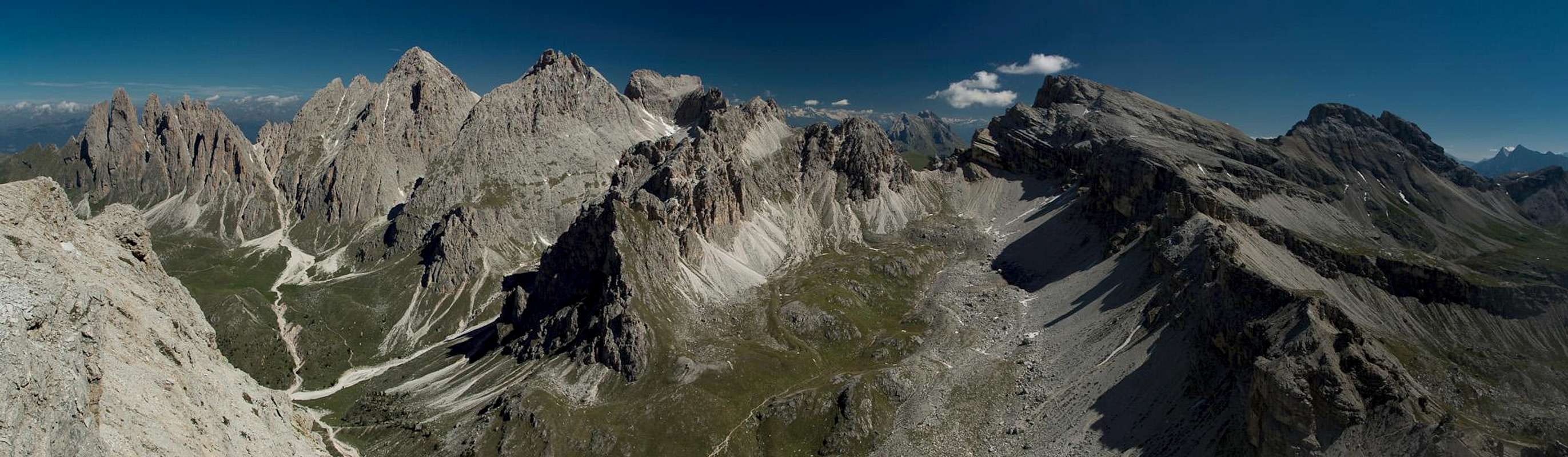
 The Geisler Group seen above Forcella Forces di Sielles. The route to the right
- General:
- Start altitude: 1721m (Daunei)
- Summit altitude: 2909m
- Prevailing exposure: West
- Type: Protected Hike
- Protection: Few sections
- Start altitude: 1721m (Daunei)
- Effort: 4 - Elevation gain: 1570m
- Power: 3 - Long and strenuous
- Psyche: 2 - Moderately exposed in several places
- Difficulty: 2 - Easy
- Orientation: 2 - Easy but for the immediate vicinity of Nivesscharte / Forcella Nivea
There are several alternatives how to start Nivesschartensteig, all but one of which start above the hamlet Daunei near Wolkenstein / Selva Gardena.
Via Ferrata Sandro Pertini
The sole exception is Via Ferrata Sandro Pertini, which has been described in a separate route page. It joins two of the other alternatives in the vicinity of Stevia Hut. The Pertini Ferrata is a fairly recent addition to the routes onto Munt dla Stevia. It also is rather more difficult than the remainder of the Nivesschartensteig Route.
 |  |  |
Troi San Salvester
This is the usual route onto Munt dla Stevia. Hike northward into Cislestal Val Clsles out from Daunei. After less than 1km the route starts going in a bend, heading up the west face of Pela de Vit. It finally heads south-westward towards Sylvesterscharte, from where a moderately exposed path leads you to Stevia Hut.
Expresssteig
Expresssteig also starts at Daunei but leaves the normal route only after a few steps (marked 3 soth-westward. It runs very steeply through the Stevia west face until it reaches Sylvesterscharte. There are some amazing views of Grödnertal / Val Gardena far below. From the saddle it joins the normal route to head to Stevia Hut. From the hut turn northward across the sloped meadows of Stevia-Alm until you reach the west face ridge close to Forcella dla Piza / Nadelscharte.
 |  |  |
Forcella dla Piza / Nadelscharte
Again, from Daunei, head into Cislestal / Val Cisles but stay on trail no. 3 until you reach the intersection just to the east of Regensburger Hütte / Rifugio Firenze. Here turn onto trail no. 4, which heads up the brittle scree slopes underneath Forcella dla Piza / Nadelscharte. It is a very strenuous scramble, which is also quite dangerous in the gully right underneath the needle in the saddle, which gave rise to its name.
 |  |  |
Forcella dla Piza / Nadelscharte to Col dla Pieres
From the saddle the combined route now runs in a large bend to the right of the Stevia / Montischela summit ridge. The regular trail skips the Montischela Summit but a short scramble can take you there. Afterwards the trail heads southwards towards a small buttress in the west face of Col dla Pieres. Here some wooden steps take you across the steepest section onto a ramp, which takes you through the west face of the mountain. Several switchbacks lead through a wide couloir to the summit cross. This cross is not located at the highest point of Col dla Pieres but rather in a spot where it can be seen from the valley floor. The real (very broad) summit is located a bit to the north-east.
  |
Col dla Pieres to Forcella Forces de Sielles
From the summit a path leads to the east heading for the northernmost spot of the plateau-like top of Col dla Pieres. Here a rather steep path leads through the north face of the mountain in two switchbacks. In dry conditions the path is easy and not too dangerous but wet or even snowy conditions require the proper equipment. Before you head onto the rout it is good to scout snow conditions in this place. Once at the bottom of the huge face the path heads onto a rocky but brittle ridge, which takes it to Forcella Forces de Sielles. The last steps have been secured by cables right up to the saddle.
 Langental seen from Forcella Forces die Sielles
Forcella Forces de Sielles to Nivesscharte / Forcella Nivea
You remain on the north running ridge, where another protected section takes you across the most “difficult” parts. Soon the ridge runs out onto a sloped karst plateau, across which a well marked path leads. In places orientation gets a bit ambiguous as far too many cairns lead the way. After two large steps you reach the area of Nivesscharte / Forcella Nivea, where the density of cairns is ridiculous. The official Nivesschartensteig turns off left but if you plan to go to Piz Duleda, stay northward bound.
 |  | |
Piz Duleda
From Nivesscharte / Forcella Nivea head northward. There is another terrain step until you reach the almost flat section just beneath the summit. The path leads to a secondary summit to the east of the real one before heading towards a narrow rock bridge which connects to the real summit. There is some moderate exposure on the bridge but none on the summit, even though west, north and east faces drop steeply for several hundred metres. Piz Duleda is one of the most fascinating lookout peaks in this section of the Dolomites. Return to Nivesscharte / Forcella Nivea by the way you came.
 |  |  |
Nivesschartensteig / Sentiero Forcella Nivea
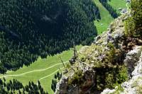
There are two options to descend back to Daunei. Either head back to Forcella Forces de Sielles from where a steep westerly descent takes you to Regensburger Hütte / Rifugio Firenze or head onto the “real” Nivesschartensteig / Sentiero Forcella Nivea, after which the whole patchwork of routes has been named. This is a protected trail which heads steeply down through a couloir onto a ledge, which takes you all the way to Forcella de la Roa, the pronounced saddle which separates the Geisler / Odle Group from the Puez Group. Here you have a last view of the alpine main ridge to the north before heading onto trail no. 3, which takes you to Regensburger Hütte / Rifugio Firenze and on to Daunei. This last section is seriously boring unless you hike it in late spring / early summer when the meadows are blooming with thousands of orchids.
 The Fermeda Towers of the Geisler Group seen during the descent from Nivesscharte