
-
 3632 Hits
-
 75.81% Score
-
 6 Votes
|
|
Route |
|---|---|
|
|
46.54245°N / 12.73607°E |
|
|
Hiking, Scrambling |
|
|
Summer, Fall |
|
|
Most of a day |
|
|
Hike and Scramble |
|
|
Overview
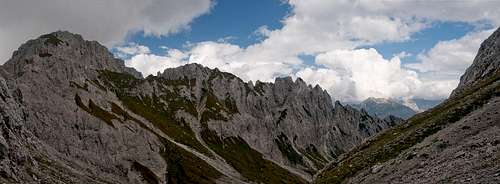
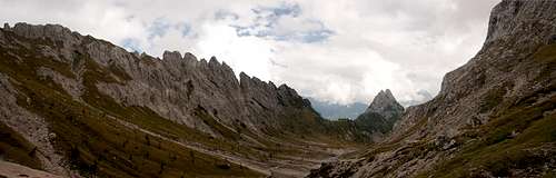
 Creton di Tui seen from the route Creton di Tui seen from the route |
From a hiker's point of view the normal route to Monte Creta Forata is as hard as it can get. Though it is not exactly difficult, though exposure is reduced to a few passages, the ascent is long and very uncomfortable. In its lower parts there are scree gullies, where rockfall has taken its toll on the path but it is the final ramp-like ledge which creates most excitement.
Have a look at the signature picture, where you can see this ledge traversing from the bottom right to the notch between the two summits. It is steep and much of it runs across scree covered slabs, which in wet conditions become soapy and slippery. In its topmost part the route balances across a handful od scree gullies, which drop away into the abyss and only the very topmost 40m have you return to normal solid hiking conditions, albeit on an exposed ledge. On the signature picture this part is hidden behind the main summit.
For the lower parts of the route - up to Vallone della Creta Forata there are two alternatives, which can be combined in a long loop. Both alternatives will be described here.
Getting There
 Cresta dei Pettine
Trailhead for both of the alternative routes is the parking lot at the ski lift of Cimasappada. The main page details the itineraries to the location.
Route Description
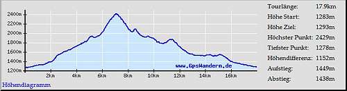 Route profile Monte Creta Forata
- Start altitude: 1280m
- Summit altitude: 2462m
- Prevailing exposure: West
- Type: Hike and Scramble
- Protection: none
Alternative 1: Rifugio Monte Siera
 |  |  |
From the parking lot of the ski lift, at least two routes lead to Rifugio Monte Siera. The one follows a maintenance road, marked 321, which stays close to the ski run and crosses it several times. A second route, marked 319, follows another dirt road for several hundred metres, before heading steeply upwards through a dense forest. This route can be difficult to find, especially if there are logging activities going on. It finally heads out on the ski run and joins the other route about 500m from the rifugio.
From the rifugio, follow trail 321 which heads for the topmost part of a ski lift across a shallow ski run. There are no markks here, simply head for the top station of the lift. There a sign leads you to Monte Creta Forata along a path, which immediately plunges into a broad gully. The crossing of the gully is the first serious part of the route, as rockfall has eaten away moch of the brittle chute. On the far side of the gully search for the trail, which heads towards the north face of Cima Dieci.
Beneath the face a second gully needs to be traversed and you finally find yourself at the bottom of a rising ledge, which runs across the base of the mountain. The ledge has been protected by a cable and though there is moderate exposure, crossing it turns out to be easy. The trail now steeply rises, passing Cima Dieci on its eastern side and finally reaching the top of a slightly pronounced ridge, which separates two valleys. Here one of the alternatives of the second route joins heading up from Casera Geu Alta though the usual intersection is several hundred metres further onwards. Follow the ridge to the right (south) and finally head down into Vallone della Creta Forata.
Alternative 2: Casera Tuglia, Casera Geu Alta
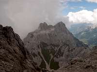
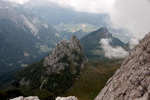 Monte Geu with the route from Casera Tuglia (behind cloud)
From the parking lot of the Cimasappada ski lift turn east and follow the main road for 200m. To the right, a forest road turns off, winding its way through the dense forest underneath Cima Dieci. The road traverses the slopes in south-easterly direction constantly going up and down before heading into a pronounced valley. Here it turns eastward and soon leaves the forest to cross a big meadow in direction of Casera Tuglia (visible from afar).
Before reaching the farmstead you will find a small shelter to the right hand side of the road. Here trail 230 turns off in south-westerly direction and steadily climbs through an pold forest to Passo Geu Basso. The pass is located to the east of the twin-peaked Monte Geu, which serves as an impressive sentinel above the mouth of Vallone della Creta Forata. From the pass the ruined Casera Geu Alta is visible and the path heads towards it directly underneath the east face of the mountain.
 |  |
From the casera the trail leads into the lower Vallone della Creta Forata, which now starts to rise towards the south-west. After about 1km the trail splits, with a steep brittle path heading out of the valley towards a ridge overlooking it. The main path stays on the valley floor and graduallly rises with the valley. Both paths recombine later on, after a step in the vaalley has been climbed. Now you find yourself in the beautiful cwm of Vallone della Creta Forata Alta.
The Ascent Route
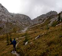
 Vallone della Creta Forata Alta
Follow the valley in direction of Forcella della Creta Forata in its end (if you find the time to visit it (15 min one way) don't hesitate to do so - nice views towards the south). Before reaching the forcella, right where the final ascent starts, a path turns off to the left (east), heading into a steep valley. It switches from the right hand side to the left and now starts to climb out of it across tilted slabs.
 |  |  |
At first the path is easy to find but later on it gets ambiguous. Stone cairns lead the way but there are too many leading in different directions or heading along different ledges across the slabs. There's a scree layer all over the place and the route gets very uncomfortable. Several steps need to be climbed before the ledge turns narrow in its upper part. Here several gullies need to be crossed on scree covered steep paths. Though exposure is still moderate the route gets outright dangerous. Finally, it climbs towards the west face of the main summit, from where a ledge takes you to the saddle which separates the two summits of the mountain (2430m).
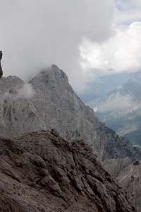
 Monte Creta Forata maain summit
In the saddle the path switches to the eastern side and follows a narrow pronounced ledge to the main summit. The northern summit can also be climbed across a moderate slope.