
|
|
Route |
|---|---|
|
|
40.21782°N / 5.59746°W |
|
|
Mountaineering |
|
|
Spring, Summer, Fall |
|
|
A long day |
|
|
UIAA - F+ |
|
|
Class 3 |
|
|
Page optimized for a screen resolution of 1280 x 1024 pixels
Overview
 La Covacha seen from Garganta de la Vega.
As I use to do, I have mixed two routes for a day. This time, it’s traveling along a crest untill reaching the highest point and returning by the valley below. That valley is called Garganta de la Vega, is to the north of La Covacha and its waterhead is a lagoon surrounded by a headwall where La Covacha is the highest point. Its western crest, called Cuerda del Risco del Águila, is the ascent route. Both, crest and valley, form a long and varied route, one of the most interesting activities you can do in western Gredos. It isn’t difficult but you have to be used to progress by rugged ground and thick bushes. In compensation, there are beautiful panoramic views on the crest and Garganta de la Vega is, with its desolate little lake, a pretty, suggestive place.
The route has three parts. First, the crest from Risco del Águila to La Covacha; this ridge is wide and rounded but with some scrubland and a lot of stony and rocky sections that can slow down progression; besaides, there are some easy scramblings near the summit. After that, the second part is to go down to Laguna del Barco from the summit; it’s a descent across a rugged and very steep slope, where there are two options, one slightly shorter and more difficult, but neither overpass II degree. Third, the final part is a road in the bottom of the valley, as a peaceful end for this route.
In sum, you can find there a sample of 100% pure Gredos but without the human crowds of other areas. In contrast, there are lots of horses, ibex... more than in the rest of the massif, looking here for some peace.
 La Covacha in the background.
Technical data:
* Accumulated elevation gain and loss: Approximately 1,200 meters.
* Minimum / Maximum Height: 1,467 ms / 2,399 ms
* Time: About 7h15, altogether, not counting stops, from Juan Calvo meadow.
* Difficulty of the whole route: UIAA F+. Small scramblings with little exposure in the area of Azagaya (I). Much of the route is an uncomfortable walking by scrub or rugged terrain. There is a climb down of about 8 meters and II degree, but can be avoided.
* Difficulty of the easier option: To go and return by the descent route, including the easier path between lake and summit, has a difficulty of UIAA F. There only are some short passages of I degree and without exposure, climbing the headwall from the lake.
* Done for the last time: September 14, 2008.
Getting There
The logical base for this route is Barco de Ávila; see Guetting There section in La Covacha page to reach that village.From there, only by car (or walking, of course) you can reach the start point: take the route N-110 towards Plasencia for 5.5 km and turn to the left, by the route AV-P-541, direction to Canaleja, Retuerta and Umbrías. In this small village, take the road AV-P-542 to Nava del Barco, reaching after 4 km the Pass of Umbrías, where there is a parking space on the right; leave the road, pass through it and continue by a dirt track. Total distance from Barco de Ávila is 13 km.
By that dirt road, a meadow with source (called El Llano or Juan Calvo), about 2.5 km away, can be reached with a little care by a normal car; this is a traditional place for camping and many people prefer to get out of there to reduce in an hour a route that is already long.
Moreover, with an 4x4, you can go further up, to the refuge of Paso de Palomas, 1.5 km away, or at the beginning of the Crest of Risco del Aguila, which would remove about 3 km more that, go and return, reduce the walking time in 1h45.
 View from La Covacha to the North.
Route Description
Itinerary: Fuente de Juan Calvo - Cardiel - Cuerda del Risco del Águila - Portilla de la Angostura - Azagaya - Covacha - Collado del Losar - Laguna del Barco - Garganta de la Vega - Cuerda del Risco del Águila - Fuente de Juan Calvo. Map taken from the sheet “VALLE DEL JERTE” (1:50,000) by Editorial Alpina.
1.- The ascent: along the crest from Risco del Águila
From the meadow of Juan Calvo, walk to the southwest, continuing the same road that comes from Puerto Umbrías. To the left, on the other side of Garganta de la Vega, Cancho del Mosquito can be seen and more far the crest that would lead you to La Covacha. Following the road and yellow-and-white marks of PR-AV-36, placed on wooden posts, you will pass next to the hut of Paso de Palomas and the apex Cardiel, passing through several gates before reaching the end of the crest of Risco del Aguila. From there, you can see Garganta de la Vega with Cancho del Losar, La Covacha and La Azagaya outstanding on the top of the head circus. From the road, some detour outs but PR signs leave no doubt of the direction to follow. Likewise, it is also clear the path from here: on the top of the crest until the highest point. Cancho del Mosquito.
 Cuerda (Crest) of Risco del Águila.
When trail and PR turn to the left (S) to go down to the valley, go straight ahead (SW) along the divide, near the fence on it. There is some bush on the ridge but that no overwhelm. Some cairns, quite separate and not always well visible, can guide you to the best way but I think it’s better to trust one's own instincts because the scrub is alive and more or less dense areas vary almost every year; and of course, there is nothing like a road. When you arrive at Risco del Águila, climb by the stacking rocks to pass it by the top, better option than trying to surround it through the bush. From this modest prominence to Mojón Alto, the ridge is smooth and wide and scrub declines. When starting the slope, leave the ridge and go by the left (E) side, where a rocky ravine allow a more comfortable walk, avoiding the bush. With Mojón Alto in sight, climb diagonally by a loose stones and grass gound, going parallel to the ridge that you will gain at the top of the ravine. Once there, go along the ridge until the great cairn of which marks the highest point of Mojón Alto.
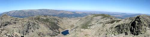
 View from Risco del Águila to the North.
 From Risco del Águila to Mojón Alto.
From Mojon Alto, follow the ridge by a gentle slope of quarry first and meadow after at the foot of Castilfrío. In the pass, take a footpath that pass by a soft meadow, in the eastern flank, sheltered between cliffs, which is a great place to spend a night when the water runs by the stream in its axis.
 From Mojón Alto to Castilfrío.
 North slope of Castilfrío.
Follow the footpath, reaching directly Portilla de la Angostura, without going through the Castilfrío summit, which you will leave on the right (W). In this large pass, turn slightly to the left, following the divide to the southeast, to go to Canchal de Ballesteros, Azagaya and La Covacha. Before reaching Ballesteros, there is the first scrambling of the route in Altos de Solanilla, a narrow rocky prominence whose better way to surpass it is over the top ridge (I). Behind this, a slope of medium-sized and well settled stones, allow to reach easily Canchal de Ballesteros.
 From Portilla de la Angostura to La Covacha.
 Altos de Solanilla.
Shortly after surpassing Ballesteros, the ridge sharpens again and there is a short narrow passage (I +) prior to climb to Azagaya, usually by a gully in the left flank (N) of the ridge. The ground is there covered of large and well established blocks, with cairns marking the easy path. Following them, there is a few to climb and a lot to scramble, with very little difficulty or exposure. I have read several references that consider a difficulty degree of UIAA - II or even III in this passage but that’s not so. Of course, I talk only about the marked path; in the surroundings, there are many possibilities to do the things more complicated.
 From Ballesteros to Azagaya.
 Gully of Azagaya.
From Azagaya, go down by a steep slope of loose stones to a gap, from which it undertakes the final climb. This latest stretch is a rocky hill where a few rocks outstand but always can be avoided by the right (S) flank. The summit landmark of La Covacha is on top of a natural stones turret, a couple of meters tall, which can be climbed easily by anywhere.
 From Azagaya to La Covacha.
 From La Covacha to Azagaya.
2.- The descent: Garganta de la Vega
To get back, go down first to the northeast, by large blocks and slabs of moderate slope, toward the gap between La Covacha and Cancho del Losar. At the beginning, there are cairns that seem to indicate the path but you have to leave away to the right because, in reality, they mark the descent to Laguna de los Caballeros, in the East side of the mountain. The rigth reference is El Losar. Once on the gap above, go down by the left (NW) ravine, following (now, yes!) the cairns, which do not lead by the bottom of the stream but by the top of the rocky spine in the left, which is a ground more comfortable and easy to walk and by where the descent is very fast. Cancho del Losar.
 Going down by the slabs.
Upon arrival at the sight of a grassy landing, the cairns marks to the left, to follow another ravine, down to Laguna Cuadrada (green line in the photo). This descent is the easiest and you just have to follow very closely the cairns to go through a succession of terraces, linked by stony gullies, more or less uncomfortable, but with little difficulty (I). However, I recommend another path (yellow line), which is more uncomfortable and rugged but much more direct and quicker than the usual one. It takes half an hour less and there are several steps to climb down (II) and some scrub; even so, for people used to this kind of ground, I think it is a convenient option, especially in autumn when days are short. For the fast descent, go down from the landing above to the east, toward the stream that falls from Portilla Honda. To achieve its bottom, a 8 or 10 meters tall rocky step must be climbed down, by anyone of the chimneys that cut it. There are several and all of them are very similar, made of solid rock and with good grabs (II). Then, turn to the left (NE), to go down along the waterbed of the ravine, better by the right bank, with sections more or less steep and rugged.
 The two descent options.
 Western gully of Portilla Honda.
After climb down some other small steps, between I and II degree, you will come to a very steep slope covered with tall bushes. Go down toward the lagoon (Laguna del Barco) in the valley below, looking for less dense areas and stone quarries. Once in the bottom of the valley, encircle the lagoon by the left side (W). Although it suppose to give a small detour, there is a footpath there and I think that anyone will have had enough stones and bushes for a day. When you reach the dam, cross it to the hut of Laguna del Barco, where you will find again the marks of the PR-AV-36 trail, pointing to a stony road that goes northward, by the right side of Garganta de la Vega.
 Laguna del Barco.
 La Covacha, seen from Laguna del Barco.
Take the road, which lead by this broad valley, crossing delightful, meadows, which frequently are half flooded, where cows and horses graze and sometimes the ibex appears too, as a sign that breeding is possible without ending wild life. The road passes through some gates and next to a waterfall, before arriving at another hut, called Chozo de Anselmo. Then, it leave the valley climbing diagonally its left hillside, by moderate slope, to arrive to the place where, on the way out, you've left the PR-AV-36 for climbing to Risco del Águila. From there, do the reverse way to get back to the Source of Juan Calvo.
 Meadow in Garganta de la Vega.
 Leaving Garganta de la Vega.
Essential Gear
No technical equipment is required. Only the adequate clothes and other individual elements (sticks if you want, ice axe & crampons or snowshoes in winter, etc.) for medium / high mountain hiking in temperate areas.External Links
Regional mountain weather forecast: Spanish government weather agency.If you don't understand completely the text on this page or you want to practice another languages or simply you are a little eager, you can find the original issue in Spanish in the website Pirineos3000.com (La versión original en español de esta página se encuentra en Pirineos3000.com)