
|
|
Route |
|---|---|
|
|
38.53330°N / 35.46670°E |
|
|
Snow/Glacier |
|
|
A few days |
|
|
Moderate snow/ice |
|
|
Approach
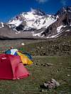
Hacilar is the last town before approach to the north side of Erciyes. Hire a pick-up from Hacilar to reach Sutdonduran plateu at approx. 2900 m. It takes about 45 mins from Hacilar to Sutdonduran. Sutdonduran is the general camping place for this side. You can find water in all seasons and feel quite remote from people.
 |  |  |  |  |
Route Description
There are two main routes on the face:
1. Kulvar: (Right one on the topo)
Rises 40' and reaches the col. From here turns left and continues up following the walls on the left side. The natural line is exposed. Leads to the main summit. Approx. 7 hrs. from the camp.
2.Direct:(Left one on the topo)
It is very clear on the topo. Rises slightly and reaches almost 75' at upper sections. Reaches to the east summit. Approx. 5,5 hrs.
Very enjoyable routes with concrete snow in early summer.
 |  |  |  |  |
Essential Gear
HELMET!
Ice axe, crampons. Depending on your skill and experience you might need a rope.
Miscellaneous Info
If you have information about this route that doesn't pertain to any of the other sections, please add it here.