
|
|
Route |
|---|---|
|
|
40.08100°N / 105.6727°W |
|
|
scramble |
|
|
A long day |
|
|
class 3 |
|
|
Approach
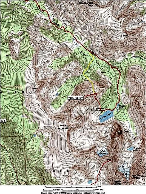
North Face Route on “Cherokee”--15 miles & 4,000-ft, RT
Starting at the Monarch Lake Trailhead (8,345-ft,) easily locate the trail from the parking area and begin an easy hike along the north shore of Monarch Lake. At 1.32 miles, the trail will leave the lakeshore and bend to the northeast up the Buchanan Creek Valley. Pass over the Hell Canyon Creek at 2.33 miles on a good bridge. Soon afterwards you will come to a flat area that was once a popular campground for backpackers called Shelter Rock Campground. It is now closed. Exactly one mile from the Hell Canyon Creek Bridge you will come to the Buchanan Pass/Cascade Trail junction.
Take the Cascade Creek Trail and cross another good bridge over Buchanan Creek. Ascend the slope ahead and listen for the first of a series of waterfalls along this fantastic trail. Follow this trail for another 1.41 mile until you reach a flat, marshy meadow at 9,664-ft.
Above you to the north (to the left) are the steep southwest slopes of Thunderbolt Peak (11,938-ft) and here you can finally see the north face of “Cherokee” straight ahead. Locate a saddle or low point in-between Point 11,602 and “Cherokee’s” 12,130-ft summit. Point 11,602 is obvious northern endpoint of “Cherokee.” That saddle should be your destination. Also, locate the drainage to the north of “Cherokee,” ascending it will deliver you to the lower ramparts of “Cherokee’s” north face.
From the meadow at 9,664-ft, follow the Cascade Trail .57 mile and leave the trail at 9,775-ft before the trail begins to ascend steeply out of the meadow. Going forward, you will not have a trail. Drop down a bit into the woods and start a moderate bushwhack through the trees, heading for the steep lower slopes of the drainage that will deliver you to the north face. Cross Cascade Creek, and start the ascent up into the drainage, staying north (to the right) of the creek as you climb. This cascading creek forms a tiny gorge and getting across it presents a problem until you reach about 10,384-ft. At this point you can find a weakness in the gorge, crossing it with a short but difficult bushwhack down into it and up out of it.
Route Description
Start to make your way of the steep slope (easy class 3) and continue another 900 vertical to the saddle at 11,500-ft between Point 11,602 and “Cherokee’s” summit. The view of “Cherokee from this spot will surprise you, it looks like a completely different mountain! Take the time to run the exposed northeast ridge out to Point 11,602. The views from here are amazing.
From the saddle, do an ascending traverse into the center of the north face to avoid the tower-ridden crest of “Cherokee’s” jagged northeast ridge. Locate the steep, broken, class 3 slope to the left of an obvious gully that ascends to the summit area. The obvious gully can be climbed but is loose, and the steep, broken slope to the left is on better rock. Once above this slope, climb class 2+ talus to the summit ridge and locate the true summit that includes a small catwalk out to a very exposed perch overlooking the abyss-like Crater Lake Basin. The views from the summit will blow you away.
For the descent, I highly recommend descending from the saddle in-between Point 11,602 and “Cherokee” down into the Crater Lake area. From the saddle, expect a boilerplate-ridden descent intermixed with grass alleyways. There will be a few short headwalls to negotiate as well. The view of Lone Eagle during this pleasant descent will astound you, guaranteed! When you finally reach the beautiful Crater Lake, locate a trail that will get you back to the Cascade Lake Trail for a 7 mile return back to Monarch Lake.
Essential Gear
Long climb, keep an eye on the weather.
Miscellaneous Info
If you have information about this route that doesn't pertain to any of the other sections, please add it here.