-
 3236 Hits
-
 79.04% Score
-
 10 Votes
|
|
Route |
|---|---|
|
|
38.11100°N / 119.457°W |
|
|
Mountaineering |
|
|
Spring |
|
|
Half a day |
|
|
Class 4 |
|
|
Moderate snow and class 3/4 rock |
|
|
Overview
A very scenic, semi-technical route that shows off this mountain at its best. The north side of Crown Point is a deep glacier bowl surrounded by steep cliffs from the east, south, and west. The cliffs are breached by a north-facing gully that tops out on the summit ridge. The route involves getting into the bowl from the north, climbing the snow up the gully, then climbing blocky class 3/4 granite to the summit.
The best time to climb this route is in mid to late spring. The gully melts out later in the summer, and scrambling up the scree and talus would not be nearly as pleasant as a snow climb. On the other hand, the 10-mile approach is much easier once the trail is snow-free. There is only a narrow window of time (a few weeks between April and June, depending on the snowfall that winter) when the approach trail is already mostly snow-free, but the north gully is still covered all the way to the top. In 2012, a low-snow year, May 19 was almost too late.
Getting There
The east shore of Peeler Lake makes a perfect base camp for this climb. There is plenty of flat ground and big trees near the lake, making for comfortable sheltered campsites. In late spring you'll be able to get liquid water from the lake or nearby streams. The best approach to Peeler Lake is from the Twin Lakes / Mono Village Resort trailhead, about 8.5-9 miles. The trail is well maintained to 1 mile past Barney Lake. After that you need to negotiate two stream crossings, then the trail begins to climb and becomes less well maintained but still easy to follow. If the gully is in shape, there will be snow on the upper portions of the trail, but snowshoes are probably not necessary. You will get a good look at the bowl and the gully from your approach - you'll know if it's in shape as soon as you reach Barney Lake.
Route Description
Start well before sunrise - sun will hit the top of the gully about an hour after sunrise, and you want to top out before the snow gets soft. From Peeler Lake, head east, following the line of least resistance until you reach the two small tarns half a mile east of the lake. From there, climb southeast to gain a mellow ridge that runs north-south from the west (climber's right) cliffs of Crown Point, then follow that ridge south until you run out of bare rock. This is a good place to put on crampons and any other gear you wish to use. From the ridge, drop down (east) into the bowl, turn south, and head for the obvious gully. The slope will get steeper as you climb but never get past 40-45 degrees. Most people should be comfortable climbing it solo in most conditions. Once you top out, you will see a broad summit ridge going west (climber's right). With careful routefinding, you can keep it to a class 3 / low 4 scramble that does not require any technical gear. You'll have great views in most directions as you climb. The summit will be obvious.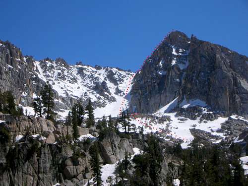

Descend the northwest slope back to the lake. The main problem is the dense, sappy pine brush that covers that slope. Earlier in the season it's covered with snow - and that's a good incentive for climbing early. To avoid it, you'll have to downclimb some steep hard snow and class 3 rock. Once you reach a broad saddle to the north of the two tarns where you started, it is safe to glissade down to the tarns. The round trip from the camp and back should be 5-7 hours at a leisurely pace.

