Route Description
I woke up early one Saturday morning - around 5:00AM - without any previous plans and decided, spontaneously, to check out the Mount Conness area that day. So I drove for about 4 hours or so to arrive at the starting point of the typical Mount Conness North Ridge climb. Having done the North Ridge already, I wanted to see if there were any alternate routes from the Glacier side of Mount Conness. I had already known of at least one route - the Y Couloir, which is situated just East of the summit. There is a long steep ridge that is very jagged and runs West to East from the summit. I had presumed that it would be possible to gain the ridge without a belay using crampons and ice axe. So I brought some along.
To get to the starting point of this route, take Saddlebag Road (dirt road, but manageable in any vehicle). You will find this road very quickly after exiting Yosemite if you are traveling from the West.
The starting point is along Saddlebag Lake. There is an obvious trail on the West side of the lake (left side from your perspective at the TH). Follow this trail through a flat, easy meadow, and up a winding trail and you will soon be at the large bowl-shaped base of the two mountains. North Peak is clearly visible early on in the hike - you can't miss it. It is at this section that Mount Conness will become visible to you.
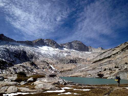
![Mount Conness NE face]() Here's your view - the one you get when you first see Mount Conness
Here's your view - the one you get when you first see Mount Conness
Snow had just fallen recently - very recently. The entire area was covered in a layer of pristine powder snow. Hiking through it wasn't of any concern until it started to become several feet deep and it was clear that I would be postholing the whole way up.
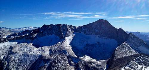
I ascended the hills to a point directly NorthEast of the glacier from which I could clearly see my route. It became apparent to me there were a few gullies that could allow me access to the ridge - my first choice was the prominent gully directly above the glacier. This would not be an option for me as I could see that there was a large bergschround - perhaps as much as 30 feet wide - that was completely impassible with my equipment and lack of a belay. Directly below this were several large crevasses which I could imagine myself falling into given the untrustworthy powder snow on the glacier - and I quickly ruled out any route involving crossing the glacier. To the left of this was the Y Coulior. This route was steep but looked manageable. However, as I gained some ground to have a closer look, I realized my ice axe and crampons were useless in these conditions, as they would essentially cut right through the fine snow and would not hold.
![Unnamed Image]()
Sadly, I realized that ascending any of the neighboring gullies to the left would probably be similar conditions, and me being by myself, didn't feel like taking on that level of risk, so I opted to head toward North Peak, which I had never done before nor did I know anything of its routes or difficulty.
It turns out that ascending North Peak you would pretty much do the ascent route for Mount Conness North Ridge, except instead of heading South to climb the obvious jagged and super narrow ridge, you head the opposite direction. A couple of things about North Peak - 1. It looks mean and scary when viewed from the approach route and from the East/Southeast. But once you gain the North Ridge the climbing is really straight forward. 2. There is almost non-existent exposure and the route finding is very easy. The other side of the mountain is sloped much like Mount Whitney, and you find yourself at the top before you know it. Having said that, I would say it's a fun day hike, probably at little too easy for most who are into mountaineering, but probably a good intro if you have never in your life climbed a real legit mountain. However, you may notice that there are steep faces on the East and Northeast, as well as several popular couloirs for ice climbing. On this particular day descending was a little more tricky because of the powder snow, which added a little challenge. The view of Mount Conness is amazing.
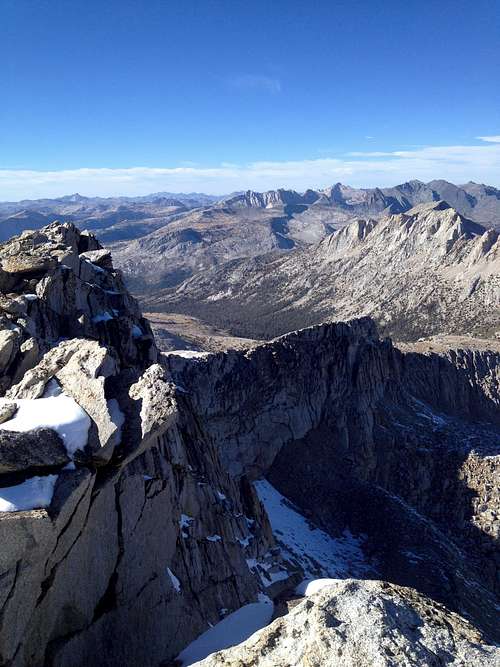
![View from North Peak looking North]() Not quite as nice as the view looking South, but still a good summit view.
Not quite as nice as the view looking South, but still a good summit view.
The summit is a typical Sierra pile of talus rocks at the top of a ridge - one side highly exposed and the other not so bad.
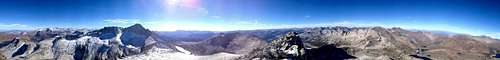
![Summit panorama at North Peak]() You can see quite a bit up here - but clearly the most interesting feature in the area is Mount Conness
You can see quite a bit up here - but clearly the most interesting feature in the area is Mount Conness
Even after wasting a few hours looking for a couloir to access Mount Conness, I made it back to the car by 6:30PM (and spending considerable time on the summit taking pictures). I brang a large bottle of water, but water sources are abundant in the basin below. I think I started the hike some time around 9:00AM. Maybe 9:30AM. In any case, this is definitely a day hike. I always recommend bringing a headlamp just in case the worst happens. Even on easy hikes.
On a side note, if you haven't done the North Ridge, do this climb. It is extremely spectacular and I think it literally changed my life.
Comments
No comments posted yet.